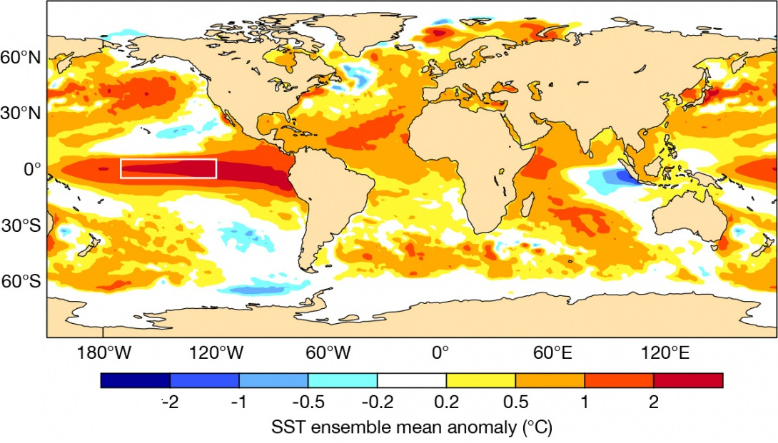
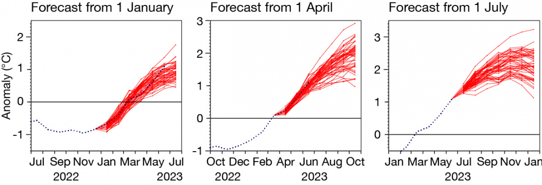
ECMWF forecasts and forecasts provided by the EU‑funded Copernicus Climate Change Service (C3S) implemented by ECMWF have been consistent throughout the first half of 2023 in indicating the development of an El Niño event, which is now in progress. The first figure shows how the El Niño might look later this year, and the second figure shows successive ECMWF forecasts for the NINO3.4 region. Despite the accuracy of these forecasts so far, we know that forecasting El Niño is sometimes tricky. What are the uncertainties in our forecast, and how can we assess them?

Main uncertainties
The most basic uncertainty on seasonal timescales stems from unpredictable wind variations over the equatorial Pacific, which can be quite large scale in both space and time (10s of days and 1,000s of kilometres). The zonal component of these wind variations along the equator strongly affects the ocean dynamics, driving substantial variations in NINO index sea-surface temperatures (SSTs). We account for this uncertainty by running ensemble forecasts – the details in each ensemble member evolve differently, and we obtain a ‘plume’ of forecast SST values. The ensemble is constructed to take account of uncertainties in the initial conditions for both atmosphere and ocean, but it is in fact the wind variability during the forecast that dominates the spread between ensemble members.
Taken at face value, the plume from our latest July forecast suggests we can expect a moderate El Niño event peaking at 1.5°C, or a very large event of 3°C, or anything in between (see the second figure). But is it this simple?

Forecast models are imperfect, and although remarkably realistic in many aspects even when integrated for a year or more, they develop various biases and subtle distortions. For El Niño, even small differences in temperature gradients can have a substantial impact on atmospheric evolution, and model imperfections inevitably lead to errors in the forecast plume. Our representation of initial condition uncertainty, particularly in the ocean, is also imperfect. It is thus no surprise that when we compare the ensemble spread, averaged over many cases, with the average root-mean-square forecast error, we discover that for SST indices such as NINO3.4, the error is bigger than the spread. Our real-time forecast uncertainty is thus (on average) larger than the spread of the forecast plume, and detailed information on this is provided by verification plots on our website.
The width of the plume could be inflated to match the overall level of forecast error seen in past cases, but there is ambiguity in how this might best be done. Physically, the impact of model imperfections is not random but state-dependent, so how a specific forecast such as that of 2023 might be affected is unclear. There are not enough past cases to create a state-dependent probabilistic calibration of our forecast models, so how to proceed?
What is El Niño?
El Niño is a large-scale heating of the equatorial Pacific Ocean. Under normal conditions, a cold tongue of upwelled water extends along the equator from Peru and Ecuador towards the date line. The upwelling is driven by easterly trade winds along the equator, which in turn are driven by large amounts of deep convection over the western Pacific and Indonesia. In El Niño conditions, the cold tongue warms up, deep convection moves eastwards towards the central Pacific, and the trade winds weaken. These processes reinforce each other, producing a sustained change in the atmospheric circulation with impacts across the globe.
Value of multi-system forecasts
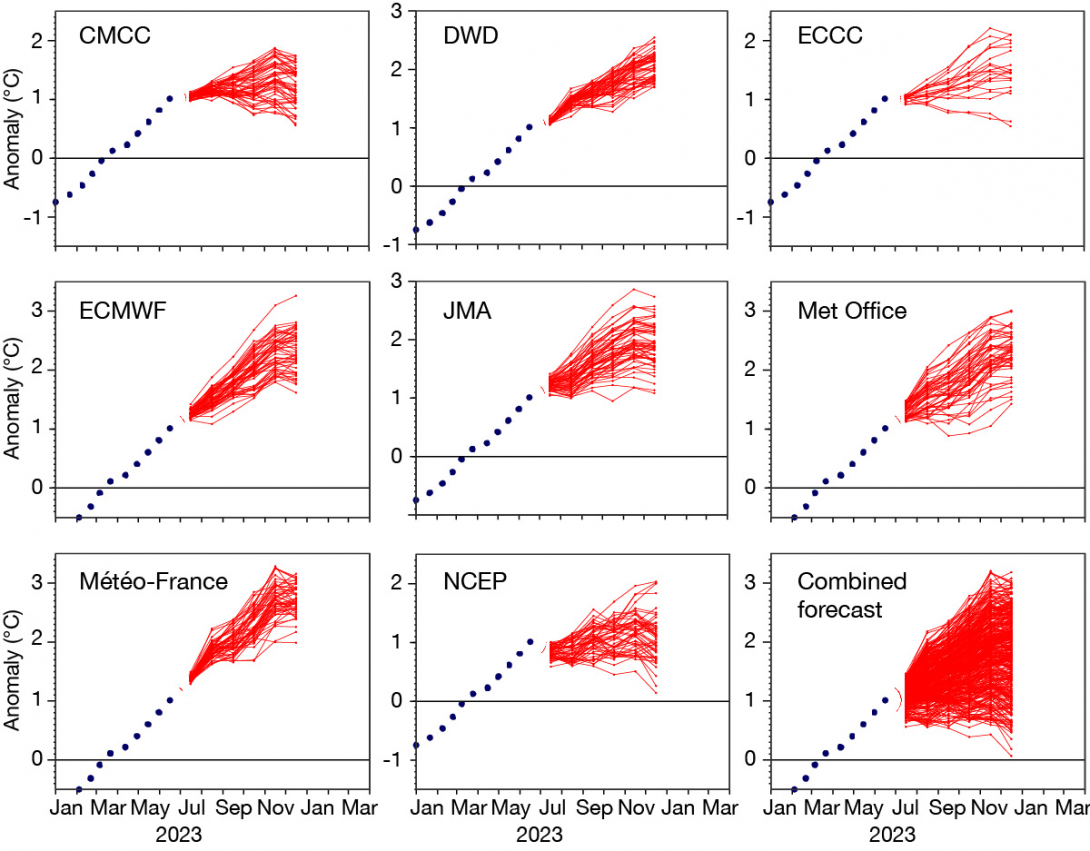
A valuable method is to combine the results from multiple forecast systems, which is the aim of the C3S multi-system seasonal forecast (see the third figure). Forecast errors introduced by model imperfections differ across models, so by averaging results the error in the ensemble mean forecast is reduced. The use of different ocean analyses also improves the representation of ocean initial condition uncertainty. Further, the spread between different forecast systems can give guidance on the robustness of any signals present. Using multiple forecast systems is a rather ad hoc method of sampling uncertainties and does not automatically result in a well-calibrated probability distribution function. However, experience shows it gives robust improvement in both skill and statistical reliability of seasonal forecasts.

Influence of a changing climate
A final source of uncertainty is the rapidly changing Earth system climate. Our calibration and error estimations come from the past, and although ECMWF’s seasonal forecasting system SEAS5 and other models capture global warming trends well, some recent regional trends in the tropics appear to be wrong. Examples include small trends in upper-air wind shear over the Atlantic and SST in the eastern equatorial Pacific, which in recent years has tended to be cooler than model predictions, due to stronger than expected winds. Some of this might be chance, but there might be systematic problems in our models, such as inadequate cloud feedbacks, failure to represent tropical deforestation and biases interacting with changes in observing systems. Different calibration choices would affect the amplitude of the predicted 2023 El Niño – it would be 0.2 degrees less if we used only the last ten years of data, for example, rather than the 1993–2016 period. A final source of uncertainty is stratospheric water vapour injected by the unprecedented Hunga Tonga eruption in 2022 – this is expected to give additional modest warming on a global scale, but any possible impact on El Niño is unknown.
Despite all these unaccounted-for uncertainties, the biggest factor determining the size of the El Niño is still likely to be unpredictable variations in the wind, for which our plumes give reasonable guidance. The future will tell whether the El Niño of 2023 exploded, developed more moderately, fizzled, or even became a slow-burn two‑year event.
