In December 1973, R.M. Morris of the UK Met Office gave a lecture on ‘Synoptic Meteorology in the Mediterranean region’ at the Meteorological Office College in Reading. R.M. Morris had served for a long time as a senior forecaster in Cyprus gaining knowledge and skill on weather forecasting in the Mediterranean. Two subjects drew the author’s attention due to their importance for the configuration of weather systems over the Balkans, including Greece: a) the origin, structure and movement of depressions in northwest Africa and b) the possible interaction between polar jet streams (PJS) and subtropical jet streams (SJS).
The interaction between PJS and SJS is different in this region from the usual one. This well-known atmospheric circulation process contributes mainly to the rejuvenation of depressions whose origin is in the relatively low latitudes during northern hemisphere cold seasons, transforming those to vigorous extratropical systems. Many publications in the international meteorological literature have studied this phenomenon. Prezerakos at al. (2006) referred to most of these papers and stressed the important role of the interaction of the right-side entrance of a polar jet (PJ) streak with the left-side exit of a subtropical jet (SJ) one.
The author studied north African depressions, leading to three papers published in the International Journal of Climatology, revealing their baroclinic nature. The findings presented in these papers combined with the findings in the author’s earlier publications (Prezerakos et al., 1990; Prezerakos & Baltasis, 1977; and Prezerakos, 1985) to provide a comprehensive picture of north African depressions. In addition, many papers have been published in the international meteorological literature considering the subject mostly from the point of view of stratospheric intrusion of the Polar Vortex (PV). However, maxima of PV greater than the value of the dynamical tropopause should be examined more carefully before being characterised as ‘stratospheric intrusions’. Analyses of thermal (not dynamical) tropopause and maximum wind charts indicating the positions of its sharp folds should be considered, because the sources of vorticity are many and variable inside the troposphere.
In this article, we briefly present the main findings resulting from the study of atmospheric circulation conditions occurring when the SJS advances poleward far from its normal position over Crete in summer. We have discovered that, when the SJS shifts its position poleward far from Greece, or a sudden transformation of the atmospheric circulation index from high to low occurs, a large-scale anticyclone with tropical tropopause (mostly depicted as a sort of blocking with a SJ streak just at its north flank) is created, bringing drought and heatwave conditions. However, another finding is equally important and much more interesting and frequent, because it is closely associated with spells of Etesian wind outbreaks over the Aegean Sea (Prezerakos, 2022). This finding refers to cases in which the SJS is situated over the Greece mainland. Then the frontal surfaces associated with the PJS or a polar jet streak passing through Greece coming from the north cause severe weather in northern Greece, as far south as Larisa (39.39°N, 22.26°E). Precipitation does not usually occur south of Larisa because the SJS constitutes a barrier for the southward extension of the upper half of the frontal surface. In this case, cold advection occurs in the lower troposphere, resulting in a drop of temperatures even in southern Greece, due to the establishment of an Etesian wind outbreak. Thereafter, these north-easterly winds stay for a long time and weaken gradually, due to the combination of a mobile dynamic anticyclone positioned over the Balkans, after the passage of the cold front and the summer permanent Cyprus surface low. The main finding of this article is that the case of 7–10 July 2022 differs from the conceptual model mentioned above. The data used in this article are ECMWF’s operational analysis and charts from the websites of the meteorological services of Greece, Italy and Germany.
Ordinary interaction between polar and subtropical jet streams – a case from July 1998
Figure 1 is a schematic depiction which shows successive stages of the interaction between both jet streams, PJS and SJS. At stage 1 the SJS adopts a position over the Greece mainland around 38°N at 200 hPa as the northern-most limit of the Hadley cell. The PJS is shown around 45°N accompanied by a PV maximum on its poleward side. At stage 2 the SJS remains steady, whereas the PJS has moved southwards closer to the SJS. At stage 3 a part of the PJS is just underneath the SJS, pushing it southwards. As the polar jet is stronger than the subtropical one, only the lower half of the cold frontal surface extends southwards, usually without causing precipitation over Greece to the south of the SJS, but only a drop in temperatures, with the simultaneous establishment of an Etesian winds outbreak. Figure 2 depicts the same interaction but refers to a real case, between 3 and 5 July 1998. During the last days of June and the first days of July 1998, the 2-metre temperature in Greece exhibited a continuous increase, with a peak on 3 July. The unprecedented heatwave was in the headlines. The Hellenic National Meteorological Service (HNMS) had forecast these high temperatures successfully thanks to ECMWF numerical weather prediction products. Figure 2 shows the positions of the PJS and SJS on 3, 4 and 5 July 1998. On 3 July, when 2‑metre temperatures exceeded 40°C at many meteorological stations in Greece, the PJS appears to be north of 50°N, and the SJS reaches a far poleward position over the Balkans. This position is represented in stage 1 (leftmost chart of Figure 2). See the thermodynamic equation box for an explanation of why 2 m minimum temperatures were at high levels during the first three days of July, while daytime temperatures exceeded 40°C in many Greek cities.


A
Quantitative interpretation of the thermodynamic equation
The thermodynamic equation in a pressure coordinate system in Eulerian form is:

where T is the 2 m air temperature, t is time, p is barometric pressure, V is the isobaric wind vector, ∇p is the horizontal gradient on an isobaric surface, ω = dp/dt is the synoptic-scale vertical component of the wind, Γ is the actual lapse rate, Γα is the dry or moist adiabatic temperature lapse rate depending on whether the air is saturated or not, cp is the specific heat of moist air at constant pressure, and H is the Newtonian heat change per unit mass and unit time caused by processes other than condensation.
All three right-hand terms of (1) contribute positively to the increase of the 2‑metre temperature. On 2 July at 00 UTC, a large wave dominates the atmospheric circulation over Europe and the Mediterranean with the main trough over the Iberian Peninsula and the main ridge over eastern Italy at 300 hPa (not shown). This synoptic situation causes (a) a warm advection toward the Balkans with maximum value over western Greece 3°C/6 h at 850 hPa; (b) a negative advection of relative vorticity of 25x10-10 s-2 at the 500 hPa level over Greece, resulting in synoptic-scale subsidence of 7 hPa/h at 500 hPa and 10 hPa/h at 700 hPa; (c) in July, during the day and especially around midday, long-wave radiation from the ground increases H to extremely high values. We can conclude that, during the first three days of July, during night time the first two right-hand terms of equation (1) contribute positively to keeping 2 m minimum temperatures at high levels, due to warm advection and the synoptic-scale subsidence, while during the day the temperature exceeds 40°C in many Greek cities.
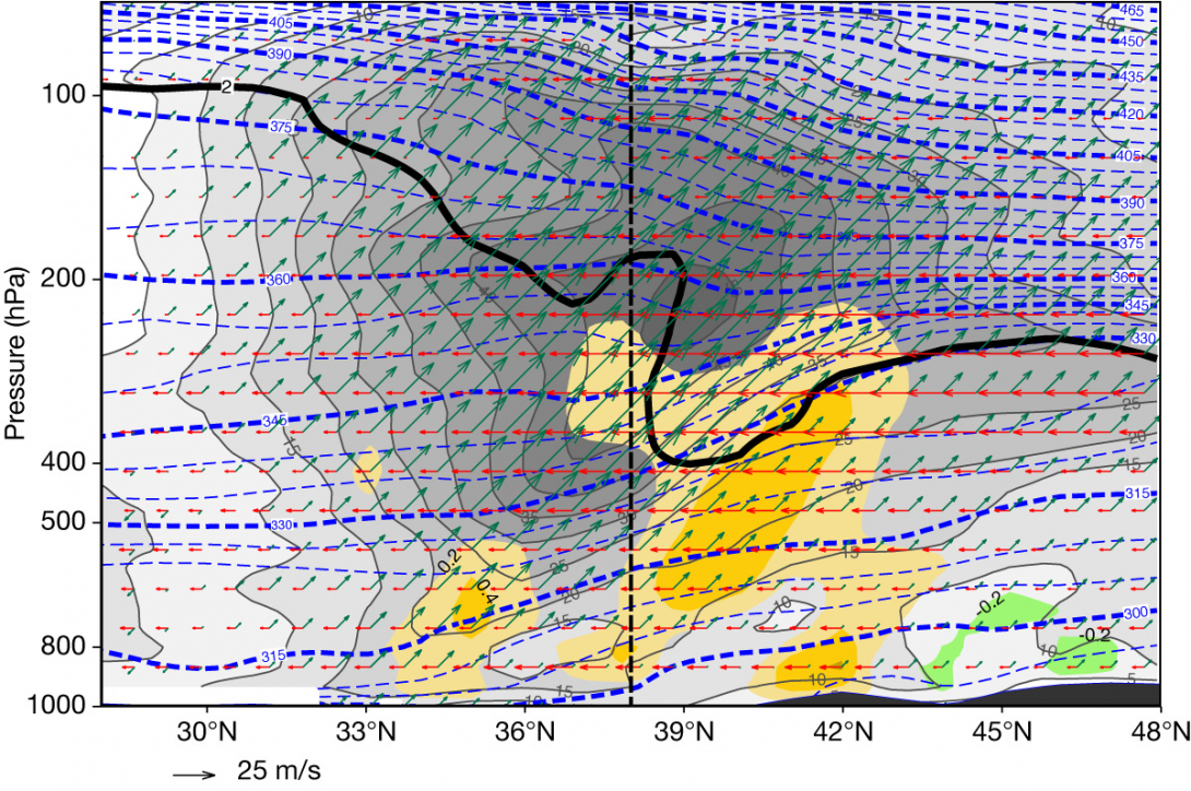
Significant synoptic-scale subsidence beneath and equatorward of the SJS was keeping the high mean sea-level pressure and temperatures. During the first three days of July 1998, tropical air masses cover Greece. The tropopause height is at 100 hPa and the temperature at this level is –71°C, which is also seen from records at the Hellinikon upper air station. The middle chart in Figure 2 is a good representation of the interaction process from stage 1 to stage 3 on 4 July at 12 UTC. Some precipitation and a few thunderstorms occurred in north-eastern Greece, which was to the north of the SJS axis on 4 July. After 12 UTC on 5 July 1998, an Etesian wind system was established over the Aegean Sea. Figure 3 is a visualisation of ECMWF’s reanalysis fully capturing the interaction at stage 3 on 5 July 1998 at 00 UTC.

The weather over Greece from 7 to 10 July 2022
Between 7 and 10 July 2022, the weather over Greece was particularly severe, with heavy precipitation and thunderstorms. As this period falls in the Etesian wind season, characterised by north-easterlies and synoptic-scale atmospheric stability, the phenomenon is rare but not unprecedented. The Etesian wind regime sometimes breaks down as a result of the arrival of a low-pressure system over the central and southern Aegean Sea, which is advected or more often created by temporary cyclogenesis establishing southerly winds in its southern and eastern sectors (Prezerakos, 2022). We will try below to identify and describe the physical processes which led to this kind of weather.
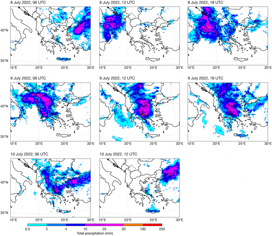
On 6 July, a low-index atmospheric circulation prevailed in the north Atlantic and Europe, with a significant wave train perturbation north of 55°N showing signs of downstream development. The Azores High extended northward to just west of the British Isles, and another particularly warm subtropical anticyclone settled almost over the whole of Europe. In summer, the permanent Persian trough extends as far as the central Aegean Sea. On 7 July, an anticyclonic breaking of the wave started just east of Britain and northwest Europe. This was used as a precursor of surface cyclogenesis over south-eastern Europe in the past. Nowadays, however, ECMWF’s Integrated Forecasting System (IFS) has replaced completely all conceptual forecasting tools of this kind. The IFS accurately predicted the exact positions and the values of geopotential heights and temperatures of the wave perturbation in 500 hPa charts, as well as the 6 h cumulative precipitation amounts in almost all of Greece during the whole three-day period, even seven days in advance. This statement is based on subjective verification and the satisfaction of the general public with accurate weather forecasts, and mainly on the special alert warning issued by HNMS. At the end of the day, a 500 hPa trough accompanied by a maximum of relative vorticity appears to be just northwest of Greece moving southwards and influencing Italy and Greece. During the morning of 8 July, severe weather occurred over most of Italy and north-eastern Greece (Figure 4). Heavy precipitation accompanied by strong lightning activity indicated the occurrence of deep convection over both countries. Surface charts obtained from the Italian Meteorological Service (not shown) depict a rather smooth low pressure field of about 1,004 hPa. They clearly mark secondary troughs and main trough centres of the wave baroclinic perturbation at 500 hPa, without any surface fronts. This fact is leading to the inference that cold advection in the upper troposphere, above a uniform warm air mass, destabilises the stratification of the atmosphere, with Convective Available Potential Energy (CAPE) building up. The release of CAPE needs trigger mechanisms to lift surface air parcels to the Level of Free Convection (LFC). These trigger mechanisms, since there is no frontal lifting, are the Greek summer sunshine heating the ground, mainly in the mountains during daytime, and the advection of relative vorticity.

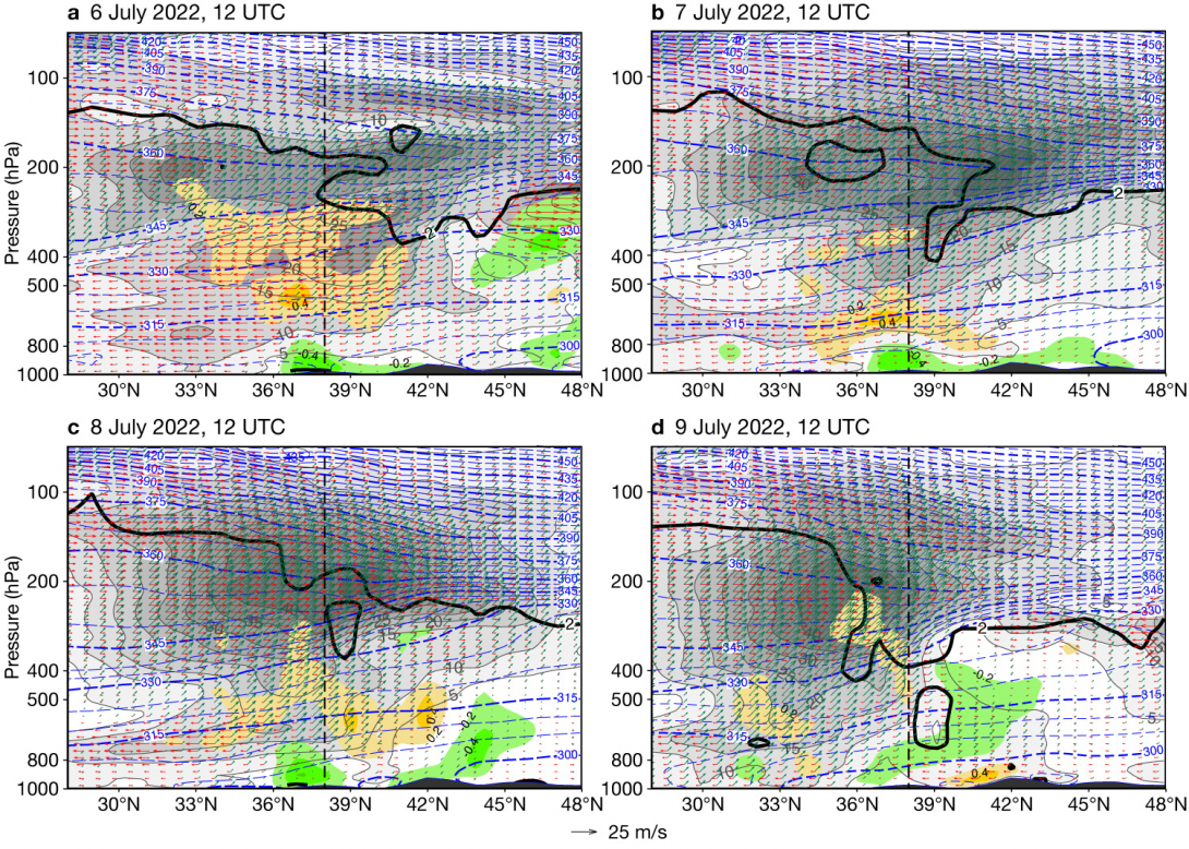
Figure 5 presents the north–south variation of wind and temperature (θ) from 28°N to 48°N, showing the weather conditions mentioned above. On 6 July, shown in Figure 5a, the location of the SJS appears to be above 33°N at 200 hPa, extending northwards up to about 45°N. The lowering of the dynamical tropopause and the parallel flow from the north indicate the presence of a part of PJS beneath the SJS just south of 45°N. That is, the main trough of the PJS is located between the orange and green areas of opposite vertical motions. On 7 July at 12 UTC, the interaction of the two jets keeps up, resulting in the restriction of the SJS between 35°N and 40°N (Figure 5b), whereas the PJS looks to be just north of Athens, beneath the SJS. During the following two days (Figures 5c, d), the SJS core is concentrated over Crete (35°N), while the PJS advances southward on 9 July. The presence of PV greater than 2 PVU at the lower troposphere could have contributed as a trigger to releasing the existing CAPE. Finally, since the maximum of vorticity had passed the previous day, the rain over Crete on 10 July (Figure 4) could be attributed to the release of CAPE due to heating of Cretan mountains in summer.

Concluding remarks
The analysis of weather conditions from 7 to 9 July 2022 revealed the predominance of mesoscale vertical motion compared to synoptic-scale motion. Although the ordinary interaction between the SJS and the PJS functioned pretty well, and the synoptic-scale subsidence usually occurring equatorward of the SJS axis suppressed the synoptic-scale upward motion due to the PJS, severe weather occurred over most of Greece. The combination of the warm air in the lower troposphere with the cold advection in the upper troposphere created favourable conditions for CAPE generation. The release of CAPE triggered deep convection with mesoscale upward motion. This motion is much stronger than the synoptic-scale one. The ordinary interaction is characterised by the presence of a cold frontal surface being followed by a cold anticyclone moving southwards as a pair. This pair is missing in this case. The cold front does not appear at all, and the anticyclone is warm, weak and too far north from its ordinary position to be very effective. Thus the case around 9 July 2022, although it shows an interaction of the two jets, lacks most of the other basic characteristics to be considered as ordinary. This was an exception.
The author would like to thank ECMWF scientist Ivan Tsonevsky for the revision of this article.
B
The author and ECMWF
The 1970s were a time when the art of weather forecasting changed gradually from a semi-empirical one to a pure physical-mathematical science. The first ECMWF seminars from 1–15 September 1975, hosted by the UK Met Office College, focused on the scientific foundations of medium-range numerical weather forecasts. They were presented by invited experts from all over the world as well as ECMWF personnel. Most of the audience, including myself, realised that much of the scientific material addressed was unknown. This event provided a strong motivation for all the senior weather forecasters present to study hard to adopt all of this knowledge to become new-fashion meteorologists.
I appreciated the valuable work done at ECMWF and its continuous improvement during my time as a forecaster and then the Director of the Hellenic National Meteorological Service (HNMS) National Forecasting Centre. Just after ECMWF started disseminating its numerical products, the weather forecasts prepared by HNMS for the general public showed an amazing improvement in quality. Soon the T+48 h 500 hPa chart showed about zero root-mean-square error for Greece and neighbouring regions. This was subsequently extended to seven days or more. Hence, Greek forecasters did not need any other numerical product coming from any other meteorological centre. Later on, a limited-area model was prepared, mainly for training purposes, by the National University of Athens and HNMS. However, its operational use was limited and temporary, and it was succeeded by COSMOGR7 and later by COSMOGR3.
In 1993, I moved to PUAS, now the University of West Attica (UNIWA), where I worked as a professor of applied mathematics and fluid dynamics. I stopped having any authority in HNMS, but I have been watching their work and kept my meteorological research interest alive. It was then that I was also appointed to be a member of ECMWF’s Scientific Advisory Committee for the next eight years. Today, I know that HNMS forecasters place high trust in ECMWF’s numerical products, which are used together with COSMOGR1. I would also like them to be used together with ICONGR because my experience indicates that ECMWF provides the best initial and boundary values to support limited-area models, especially in Europe.
To conclude, I would like to express my sincere thanks to ECMWF personnel for their continuous support provided to my research work, which often went beyond data access, and my best wishes for the success of ECMWF’s plans for the future, which will lead to even more accurate weather forecasts for longer times ahead. I am sure this will be achieved on the basis of the excellent work having been done at ECMWF to date.
Further reading
Prezerakos, N.G., 1985: Synoptic scale atmospheric wave break down at 500 hPa over Europe during cold seasons, Arch. Met. Geoph. Biocl., Ser. A34, 145–158. https://doi.org/10.1007/BF02277444
Prezerakos, N.G., 1990: Synoptic flow patterns leading to the generation of the north-west African depressions. International Journal of Climatology, 10, 33–47. https://doi.org/10.1002/JOC.3370100105
Prezerakos, N.G., 2022: Etesian winds outbursts over the Greek Seas and their linkage with larger-scale atmospheric circulation features: Two real time data case studies. Atmόsfera, 53, 89–110. https://doi.org/10.20937/ATM.52838
Prezerakos, N.G. & K. Baltasis, 1977: Contribution to the study of 500 mb troughs and their relation to frontal surfaces, Study No. 6, Department of Research, National Meteorological Service, Athens (in Greek).
Prezerakos, N.G., S.C. Michaelides & A.S. Vlassi, 1990: Atmospheric synoptic conditions associated with the initiation of north-west African depressions. International Journal of Climatology, 10, 711–729. https://doi.org/10.1002/JOC.3370100706
Prezerakos, N.G., H.A. Flocas & D. Brikas, 2006: The role of the interaction between polar and subtropical jet in a case of depression rejuvenation over the Eastern Mediterranean. J. Meteorol. Atmos. Physics, 92, 139–151. https://doi.org/10.1007/s00703-005-0142-Y
