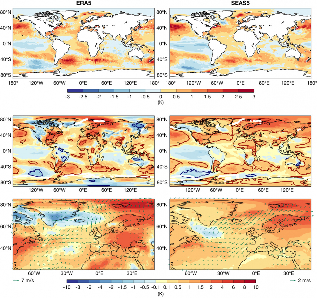
Seasonal forecasts of the winter 2022/23 in Europe were anticipated with great interest, beyond pure scientific curiosity, due to their relevance to energy security concerns across the continent in relation to the war in Ukraine. Here we review how ECMWF’s seasonal forecasting system SEAS5 performed and discuss the role of the El Niño–Southern Oscillation (ENSO) as a potential driver of large-scale circulation anomalies in the Euro-Atlantic area.
The largest source of predictability on seasonal timescales comes from the state of the tropical Pacific Ocean, with ENSO leading to teleconnections in remote parts of the world. Sea-surface temperatures (SSTs) in the central equatorial Pacific continued to be anomalously cold, resulting in the third consecutive La Niña winter. Such triple-dip cold La Niña events are rare, with only three previous occurrences since 1950.
Sea-surface temperature anomalies
The global seasonal mean (December to February, DJF) SST anomaly map from the ERA5 reanalysis (top-left panel in the figure) shows the cold La Niña conditions together with a warm tropical Atlantic and cold tropical Indian Ocean. The extratropical SSTs in the northern hemisphere were mainly warmer than during the climatological period 1993–2016. SEAS5 provided a good forecast of this situation, as can be seen in the top-right panel of the figure, showing the ensemble-mean forecast anomaly. The large-scale structures in both the tropics and extra-tropics were well reproduced with some differences in the spatial extent or magnitude of the anomalies.

Near-surface temperature anomalies
Near-surface temperature anomalies over the oceans, which are strongly linked to the underlying SSTs, were well reproduced in the forecast (see the middle panels of the figure). The observed situation over land was characterised by warmer than average temperatures over Europe, with maximum anomalies over the eastern parts. The seasonal forecasts predicted the temperature anomalies for western and central Europe well but overestimated the statistical significance and the extent of the warm signal from eastern Europe through to Siberia. North America saw a northwest–southeast dipole structure with (non-significant) cold conditions in the north-west and significant positive anomalies over the east coast of the US. SEAS5 predicted a strong north-south difference with significant warm anomalies over most parts of the US. The observed far-eastern cold anomalies over Asia were strong in magnitude and significant compared to the level of interannual variability. SEAS5 missed the cold signal there. Temperature forecasts over South America verified very well, as did those over large parts of Africa. The significant cold conditions in the north-eastern parts of Australia were only partially reproduced with SEAS5.
The North Atlantic and Europe
A closer look into the conditions over the North Atlantic and Europe is provided in the two bottom panels of the figure, which also show 10‑metre wind anomalies. While the overall warm signal over land was well predicted, the circulation showed several differences in the forecast compared with the reanalysis. Iceland, the Denmark Strait, and southern parts of Greenland experienced cold anomalies. This was due to anticyclonic conditions from the surface to the mid-troposphere that resulted in a negative observed North Atlantic Oscillation (NAO) index (not shown). The circulation around the high-pressure ridge brought a northerly wind anomaly component into Europe, especially over the North Sea, and led to weaker westerlies west of Europe and over the central North Atlantic than usual. The forecast missed the cold high-pressure centre over Greenland and instead produced more of a classical positive NAO pattern. This led to errors in the near-surface wind at Europe’s northern and western coastlines.
Reasons for the North Atlantic circulation
Which physical driving mechanism could have influenced the circulation over the North Atlantic during the winter? The cold phase of ENSO is known to have weak statistical teleconnections into the North Atlantic and Europe. These tend to lead to high pressure anomalies in November and December and to a zonal positive NAO structure in January and February. The circulation during the 2022/23 winter, however, underwent substantial month-to-month variability (not shown), which did not match the canonical La Niña teleconnection structures. On the other hand, the SEAS5 forecast model, while failing to show a consistent classical surface pressure ENSO response during November and December, did predict the expected ENSO-related zonal flow signal for late winter during January and February.
Given the correct ENSO forcing in the model, the atmospheric circulation difference over the North Atlantic between observations and the seasonal prediction can be interpreted as follows: the unpredictable internal variability component dominated the observed realisation in ERA5, while the forced component of the ENSO signal manifested itself in the ensemble-mean seasonal forecast response in the second half of the winter.
C3S seasonal predictions
SEAS5 is one of the systems contributing to the multi-model ensemble of seasonal predictions provided by the EU’s Copernicus Climate Change Service (C3S) implemented by ECMWF. Other C3S seasonal forecast models showed broadly the same seasonal-mean temperature signals as SEAS5. However, there was less consensus in the forecasts of the atmospheric circulation for the Euro-Atlantic region. The considerable variety across the models was an indication that this aspect of the forecast was more difficult to predict.
