

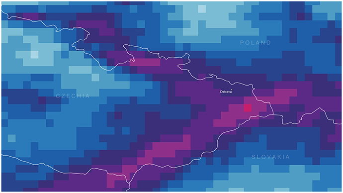
ECMWF has just made a subset of its highest-resolution 9 km data free and open. The move will give more people access to accurate and localised forecasts.
The resolution can make the difference, for example, between predicting rain in a large area and knowing which valley it will fall in.
The release of the data, which until now has only been available via a paid service agreement, comes a year after ECMWF made its 25 km resolution data free, and is part of ECMWF’s commitment to providing free and open science.
The 25 km data has already provided benefits for organisations such as the UN World Food Programme, who use it to provide timely assistance ahead of climate hazards, helping protect livelihoods and reduce food insecurity in vulnerable countries, for example during Mozambique’s severe droughts in 2024.
The 9 km resolution data provides a further step forward. With flooding, for instance, rather than predicting rain over a large area, forecasters will be able to see particular slopes and river basins where water will pile up, providing the detail a hydrological model needs to warn a particular town. At 25 km resolution, the flood peak remains diluted and its location smeared.
Roar Skålin, Director-General of the Norwegian Meteorological Institute and President of ECMWF Council, said: “Free and open data is essential not only for Europe’s national meteorological services, but also for strengthening forecasting capabilities globally.
As such, the move by ECMWF to make its 9 km resolution data free and open is a welcome step forward, particularly supporting critical global initiatives like the UN Early Warnings for All initiative. Making weather data more accessible enables more localised and accurate forecasting, which ultimately benefits society as a whole.”
Another example of 9 km resolution data being crucial for providing a more localised picture is when predicting health risks from malaria and dengue. The transmission of both diseases is highly sensitive to temperature, and terrain can place neighbouring areas on either side of the conditions needed for transmission.
At 25 km, a highland region and the warmer valleys below it collapse into a single average; at 9 km, the cool ridges and warm lowlands separate out, revealing which areas cross into the range where these diseases can spread. That allows health ministries and their partners to link forecasts more closely to conditions on the ground.
Victoria Bennett, Head of User Services Section at ECMWF, said: "Our users have long asked for higher-resolution open data, and these are just some examples of the benefits showing why increasing the resolution from 25 km to 9 km is an important step.
By making a subset of our medium-range products – drawn from the full ECMWF Real-time Catalogue – available free of charge at our highest resolution, we want to enable even more people to innovate, experiment and build new products and services. We’ve also worked to keep the data volume manageable and added parameters that will help make these forecasts accessible to an even wider global community."
ECMWF produces 100 TB of data a day, comprising over 450 parameters. While much of ECMWF’s data is freely accessible, the nature of meteorological data – large, complex, and continuously updated – poses substantial challenges for managing the volumes.
To reflect this, the 9 km open data is released with a short delay of two hours rather than in real time. This is to ensure reliable and timely delivery across the network and to maintain our operational commitments to our Member and Co-operating States which remain ECMWF’s priority.
Organisations that need the 9 km data in real time can still obtain it under a service agreement, and the 25 km data remains freely available in real time for all. All data must be attributed to ECMWF.
Florian Pappenberger, Director-General of ECMWF, concludes: "Making ECMWF's 9 km resolution data free and open is a significant step towards broadening access to world-class weather information.
Thanks to the support of our Member States, we can help national meteorological and hydrological services worldwide enhance their forecasting capabilities, support early warning systems and deliver greater benefits to society. This reflects ECMWF's commitment to scientific excellence, international cooperation and ensuring that the value of our data reaches as many users as possible."
Further reading
For more information on how ECMWF’s data, evolving infrastructure, open data, and AI-ready systems are reshaping access to weather and climate information:
- More than data: services enabling Europe’s growing user community
- Driving innovation in data provision – the Data Stores Service
- Data without friction – ECMWF’s multi-faceted approach to improving data usability
- Data sovereignty in practice: ECMWF infrastructure for European services
- Minutes matter: how ECMWF delivers time-critical data at global scale
- Data friction and the user experience: a framework for improvement
- The living archive: inside ECMWF's exabyte-scale meteorological data repository
- Powering the AI weather revolution: from ERA5 to AI-ready pipelines
- ECMWF's data infrastructure and services: ready for the era of Common European Data Spaces
- Why ECMWF needs both supercomputing and cloud services