

Realistic Earth system prediction reaches far beyond the atmosphere: the ocean, land surface, sea ice, ocean waves and rivers are all tightly coupled to the weather. Within the Destination Earth (DestinE) initiative of the European Commission, ECMWF is developing machine-learning models for these distinct components to sit alongside the operational Artificial Intelligence Forecasting System (AIFS). Having introduced this project in the Spring 2026 Newsletter (Furner et al., 2026), here we take a closer look at what the component prototypes do.
By extending the open-source Anemoi ecosystem, which is co-developed by ECMWF and its Member States – and integrating the earthkit-hydro library for hydrological inference – five distinct machine-learning models have been developed for waves, sea ice, ocean, land, and hydrology. Each component currently operates as a standalone system that draws information from the atmosphere, mirroring the way physics-based components are coupled. They run at a small fraction of the time and cost of their physical counterparts. And, as we show below, each component captures not only the typical behaviour of the Earth system but also rare and extreme events, while remaining stable across medium- to long-range forecasts.
In this article, we introduce each component and illustrate its skill with a real-world case study.
The five components at a glance:
- Waves: predicting ocean surface wave conditions, including swell, significant wave height, and direction.
- Sea ice: representing the evolution of sea-ice concentration, volume, albedo and velocity in both hemispheres.
- Ocean: modelling temperature, salinity, currents and sea-surface height throughout the ocean's depth.
- Land: emulating soil moisture and temperature, snow cover and near-surface conditions.
- Hydrology: forecasting river streamflow from meteorology and catchment properties.
Waves
Ocean surface waves, generated by wind acting on the sea surface, contribute to the exchange of momentum, heat and moisture between the ocean and atmosphere. Skilful wave forecasts are therefore essential for safe navigation and for warning of hazardous sea conditions. The wave component predicts significant wave height, mean wave direction, mean wave period, and a wave-related drag coefficient. It splits wave height across period bands so it can tell locally generated wind-sea apart from long-range swell. Trained on 44 years (1979–2023) of output from ECMWF's physical wave model and forced by AIFS winds, it produces a global wave forecast in under a minute. Its forecasts of significant wave height are competitive with ECMWF's operational physics-based system and, in the medium range, outperform it by approximately one forecast day.
case study
The “Eddie swell”
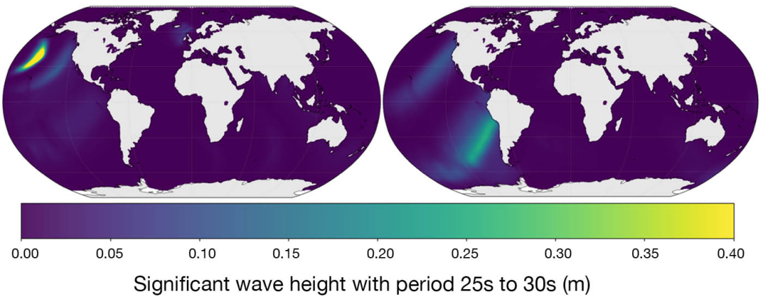
In December 2024, a North Pacific storm sent unusually long-period, large swell – the “Eddie” swell – across the entire Pacific basin, causing significant infrastructure damage along the Pacific Coast (The Conversation, 2025). This event fell outside the 44-year training distribution (1979–2023) of the model. Despite using fewer prognostic variables than a physics-based model, the machine learning prototype reproduced this out-of-sample event with striking accuracy, tracing the swell across the ocean to the South American coast six days later (Figure 1).
Sea ice
Sea ice shapes polar weather and climate, yet rapid climate change has made it harder than ever to predict. The sea-ice component is a global model that predicts both hemispheres at once, at roughly 0.25°, and 6-hourly resolution. It forecasts a full set of sea-ice variables – concentration, volume, albedo, snow volume and velocity – alongside surface-ocean fields that give it physical context. Following approaches used in physical modelling, sea-ice concentration acts as a master variable that constrains the others, keeping the system physically consistent. The prototype has been evaluated against ECMWF's coupled numerical system using the ice-edge error metric most relevant to polar users. Across all medium-range lead times, it is more accurate, with its advantage growing to around 15–20% of the total error by day 10 – an effective gain of about 1.5 days of skill, in both the Arctic and the Antarctic.
case study
European Arctic
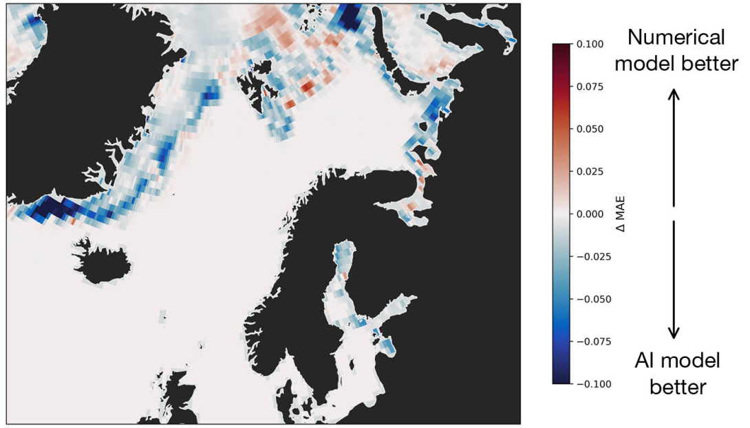
During the 2023 freezing season, characterised by particularly low sea ice conditions in the Barents and Baltic Seas, the AI model outperformed the numerical system across most of the European Arctic (Figure 2). Notably, it accurately resolved seasonal ice formation patterns in the Denmark Strait, where sea ice is brief and intermittent, especially over its 30-year training period (1993–2022). However, even short-lived sea ice significantly impacts regional weather dynamics and maritime shipping. This result highlights the model’s ability to capture rare out-of-distribution events.
Ocean
The ocean drives weather and climate on every timescale, from daily air-sea exchange to the seasonal predictability carried by phenomena such as El Niño. The ocean component is a 3D global model that predicts temperature, salinity and currents through the full depth of the ocean – 16 levels reaching depths of more than 6,000 m – together with sea-surface height. Built on ORAS6, ECMWF's state-of-the-art ocean reanalysis, and forced by ERA5 atmospheric fields, it learns how the ocean responds to the atmosphere and its own internal dynamics. When driven by accurate atmospheric forcing, its forecasts are broadly comparable to those from the physics-based ocean model NEMO, which is run operationally at ECMWF and show improved skill for global sea-surface temperature.
case study
North Atlantic marine heatwave
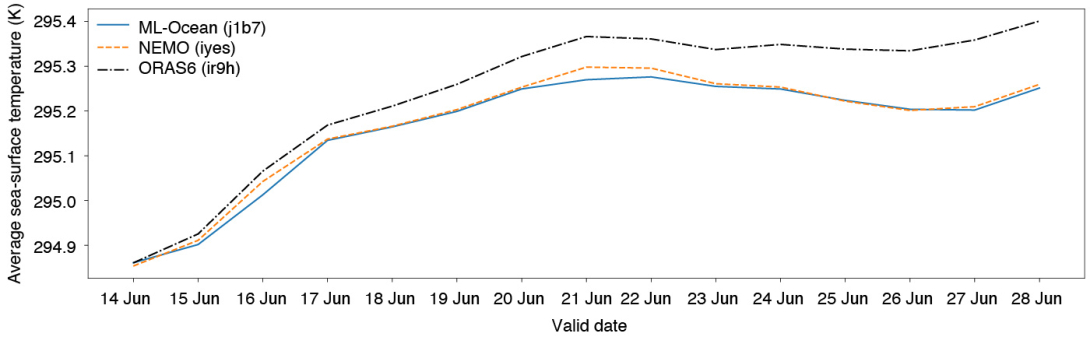
During the North Atlantic marine heatwave of June 2023, record sea-surface temperatures were observed (England et al., 2025). This marine heatwave directly intensified the downstream 2023 European atmospheric heatwave and caused widespread disruptions to marine ecosystems. This thermal anomaly rose multiple standard deviations above the typical historical variability seen in the model's 30-year training period (1993–2022). However, the ocean prototype tracked observed sea-surface temperature increases closely ten days ahead of the peak, outperforming the coupled physics-based NEMO system (Figure 3).
Land
The land surface responds to radiation, rainfall and near-surface weather across timescales from hours to seasons, while feeding heat and moisture back to the atmosphere. The land component (further described in Raoult et al., 2026) emulates an important subset of variables known to impact the atmosphere, including soil moisture and soil temperature to depths of 30 cm, and snow cover. It uses a compact multilayer-perceptron architecture suited to the column-by-column nature of the physical land-surface model from which it is trained. Rather than learning from reanalysis, it is trained directly on ecLand, ECMWF's physical land model. This means it learns the intrinsic land dynamics as represented by the model, without artefacts from the data assimilation. It runs stably for years from a single starting point while staying close to the physical model, and because it learns the underlying physics quickly and flexibly, it doubles as a diagnostic tool.
case study
European heatwave
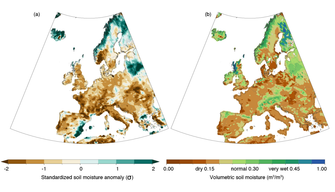
The 2022 European heatwave was one of the most extreme heat events on record, with temperatures exceeding 40°C across western Europe in July–August. This event falls outside the model's 2010–2021 training data period. While shallow soil profiles (0–28 cm) respond rapidly to immediate atmospheric drying, the moisture that plants rely on within the deeper 28–100 cm reservoir is typically buffered. The model captured the depletion of the deeper soil layers (Figure 4) which drove crop losses, heightened fire risk and created complex non-linear feedbacks to the atmosphere.
Hydrology
Global streamflow prediction is essential for operational flood mitigation and catchment management. Because river network data is sparse and gauge-dependent rather than gridded, the hydrology component implements a lumped, catchment-scale design. The hydrology component is based on a Long Short-Term Memory (LSTM) network. The model is trained using the global Caravan dataset (Kratzert et al., 2023). It takes in catchment attributes and meteorological forcings to forecast daily streamflow at river gauges worldwide, even for unseen catchments. As described by Taccari et al. (2026), the model is first pre-trained using ERA5 Land reanalysis over 18,000 stations and then fine-tuned with the Integrated Forecasting System (IFS) forecasts for operational use. In temporal testing between 2021 and 2024, the hydrology prototype achieved a median Kling-Gupta Efficiency (KGE') of 0.66.
case study
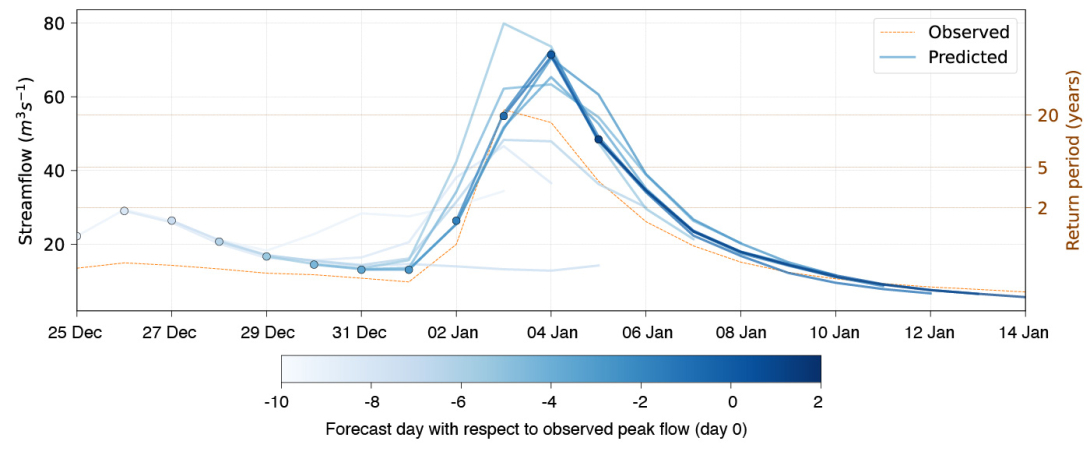
Luxembourg-province floods
The hydrology component was validated on the Luxembourg-province floods in Belgium following Storm Henk in January 2024 (The Brussels Times, 2024). This represented a severe, one-in-twenty-year hydrological event at the Straimont gauge station (182 km2 upstream area) outside of the model’s training period (1980–2019). The model successfully predicted a definitive flood signature with a lead time of six days prior to the observed peak streamflow magnitude (Figure 5).
What comes next: coupling
Under the guidance of machine learning and domain experts at ECMWF, these prototypes will keep evolving through Phase 3 of DestinE, with development focusing on efficiency, scientific robustness, physical consistency and operational relevance. In parallel, the operational AIFS is already absorbing this work: AIFS v2.0 now includes land-surface and ocean-wave fields, with sea-ice and surface-ocean variables due to follow in upcoming releases.
So far, each component has been run on its own, forced by atmospheric output from reanalysis, the IFS or the AIFS. The natural next step is to bring them together – coupling the components into a single, fully data-driven Earth system model, just as physics-based weather and climate models are coupled today. This dynamic and unified real-time integration remains the primary focus of Phase 3 and will be the subject of a future article.
More about these component models, and the wider work happening in this area, can be found at https://destine.ecmwf.int/ml-earth-system-components/.
References
England, M. H., Li, Z., Huguenin, M. F., Kiss, A. E., Sen Gupta, A., Holmes, R. M. and Rahmstorf, S., 2025: Drivers of the extreme North Atlantic marine heatwave during 2023. Nature, pp. 1–8. https://doi.org/10.1038/s41586-025-08903-5
Furner, R., S. Hahner, E. Pinnington, N. Raoult, M. Santa-Cruz, M. L. Taccari et al., 2026: Building a data-driven Earth system model at ECMWF. ECMWF Newsletter No. 187, pp. 35–39. https://doi.org/10.21957/c1dg-8k56
Kratzert, F., Nearing, G., Addor, N., Erickson, T., Gauch, M., Gilon O. et al., 2023: Caravan – A global community dataset for large-sample hydrology. Scientific Data, 10(1):61. https://doi.org/10.1038/s41597-023-01975-w
Raoult, N., Pinnington, E., Santa Cruz, M., Pinault, F., Raoult, B., Zelenka, N., Arduini, G., Balsamo, G., Boussetta, S., Chantry, M., de Rosnay, P., Dueben, P. and Rüdiger, C., 2026: aiLand v1: Physics-Based Land Surface Emulator with Observational Fine-Tuning, EGUsphere [preprint]. https://doi.org/10.5194/egusphere-2026-3620
Taccari, M. L., Tazi, K., Morrison, O. M., Grafberger, A., Colonese, J., Carton de Wiart, C et al., 2026: AIFL: A global daily streamflow forecasting model using deterministic LSTM pre-trained on ERA5-Land and fine-tuned on IFS. Journal of Hydrology, https://doi.org/10.1016/j.jhydrol.2026.136064
The Brussels Times, 2024: Belgium inundated by floods in early 2024. https://www.brusselstimes.com/860658/belgium-inundated-by-floods-in-ear…. Accessed 27 November 2025
The Conversation, 2025: How ocean giants are born: tracking the long-distance impact and danger of extreme swells. https://theconversation.com/how-ocean-giants-are-born-tracking-the-long…. Accessed 30 January 2026.