

ECMWF has begun the production of ERA6, the next-generation global reanalysis, on behalf of the European Union’s Copernicus Climate Change Service (C3S). Covering more than 75 years of data, ERA6 will supersede ERA5, which has provided reliable climate information to a large and growing user base since its launch in 2016. The ERA6 rollout will take place in phases, with the first production streams, covering 2007 onwards, expected to be published towards the end of 2027.
ECMWF has produced reanalyses since the early 1980s, supporting applications across science and industry. A 2024 study concluded that conservative estimates suggest that the marginal value of ERA5 to society exceeds €1 billion per year. ERA5 has also become a key training dataset for AI weather prediction, widely used to train data-driven weather models around the world.
A new generation of reanalysis
ERA6 incorporates nearly a decade of research and development by ECMWF and its partners. Among the upgrades (see Tables 1 and 2) is a 14 km horizontal resolution, more than twice as fine as that of ERA5. ERA6 also adds an ocean component alongside the atmosphere, land, and ocean-wave components, with initial 3D ocean conditions provided by the Ocean ReAnalysis System 6 (ORAS6) (see Table 2 for additional innovations). This extends accurate climate monitoring into the ocean and improves the physical consistency of marine atmospheric boundary-layer processes and exchanges.
| ERA6 | ERA5 | |
|---|---|---|
| Period | At least 1950 onwards | 1940 onwards |
| Timely updates | ERA6T, latency TBC | ERA5T, 5 days delay |
| IFS cycle | 49r2 | 41r2 |
| Earth system components (and resolution) | Atmosphere (137 levels up to 1 Pa), Land, and Ocean waves (14 km, TCo799); Ocean (0.25 degrees, 75 levels) | Atmosphere (137 levels up to 1 Pa) and Land (31 km, Tl639); Ocean waves (40 km) |
| Ocean model | NEMO-4, SI3 ice model | None |
| Uncertainty estimates from an Ensemble of Data Assimilations (EDA) | 10 members + 1 control (28 km); ocean (0.25 degrees) | 9 members + 1 control (63 km) |
| Data assimilation system | Atmosphere: 4D-Var with weak-constraint in the stratosphere. Surface: Simplified Extended Kalman filter for soil moisture, soil and snow temperature using flow-dependent B matrix and Optimal Interpolation for other surface parameters and ocean waves | Atmosphere: 4D-Var. Surface: Simplified Extended Kalman filter for soil moisture and Optimal Interpolation for other surface parameters and ocean waves |
| Ocean initial conditions | Ingested twice-daily from ORAS6 reanalysis 3D-Var (usage of external SST, sea ice, allowing for quality control and thinning, and altimeter satellite and ocean in-situ observations) | External daily SST and sea ice (taken as full gap-free product, with limited scope for quality control) |
| Soil initial conditions | From continuous dataset (EU Horizon CERISE project) | Cold starts, led to discontinuities |
| Output frequency | Hourly (3-hourly for EDA, single-level accumulations hourly) | Hourly (3-hourly for EDA) |
| Snow | 5 layers, plus snow on ice | Single layer |
| Radiative forcings (aerosols and greenhouse gases) | EU Horizon CONFESS project-recommended datasets; CMIP7 “H” scenario for CO2 | CMIP5-recommended datasets; RCP 2.6 scenario for CO2 |
| Data format | Fully in GRIB2, adheres to WMO units | Mix of GRIB1 and GRIB2 |
| Additional parameters | 3D clear-air turbulence, 3D specific rain and snow water content, 2 metre relative and specific humidity, reciprocal Obukhov length, orography, urban cover, sunshine duration, surface direct normal short-wave (solar) radiation, amongst others |
|---|---|
| Additional products | 3D and 2D ocean fields; 11 height levels from 15 m to 500 m above the surface; 5 snow levels; Daily and monthly statistics including stdv, min and max |
| Novel observations | Infrared (1969–2000: SIRS, IRIS, SCR, SSH, and Meteosat First Generation All-Sky Radiances); Microwave (1972–2025: NEMS, SCAMS, SMMR, SSM/T-1, SSM/T-2, SMOS); Wind lidar; In-situ surface observations from NMHS and institutions that opened access to their archives |
| Reprocessed observations | Infrared (VTPR, HIRS); Microwave (MHS); Polar Atmospheric Motion Vectors; GNSS-RO (CHAMP, GRACE, COSMIC and GRAS); In-situ balloon ascents (trajectory reconstruction; homogenisation and corrections for temperature, dew point, and wind direction); Drifting buoys (Copernicus In-Situ C-RAID project) |
| Data assimilation | Handling of stratospheric temperature bias using weak-constraint 4D-Var from and a neural network before 2007; Varying CO2 climatology for assimilation of IR sounder data; Handling of balloon drift during ascent; Slant-path radiative transfer for satellite radiance assimilation |
| Model | Increased number (18) of aerosol species; Improved snow model; Improved Flake lake model plus improved forcing datasets. Time-varying urban tiles; Solar eclipses; Improved super-cooled liquid water representation |
Observation advances
As earlier reanalyses have shown, product quality depends critically on the quality and volume of assimilated observations, particularly for periods when the global observing system was less complete than it is today.
Through international collaborations with organisations such as the National Oceanic and Atmospheric Administration (NOAA), the National Aeronautics and Space Administration (NASA) and the European Space Agency (ESA), and with C3S partners including the European Organisation for the Exploitation of Meteorological Satellites (EUMETSAT) and Space Science and Algorithmics (Spascia), the earlier ERA6 period will benefit from a wide range of rescued and reprocessed satellite datasets.
More recent years will also make use of new-generation and reprocessed observations, including soil moisture and lidar wind data, as well as Sentinel observations that could not be assimilated in ERA5.In-situ observations have also advanced substantially, supported by a decade of C3S-led work with partners such as Maynooth University and the University of Vienna to compile comprehensive land-surface, marine-surface, and upper-air observations from global contributions. Together these additional observations have been shown to significantly improve analysis quality, especially in the data-sparse southern hemisphere and the stratosphere.
Expanding the product catalogue
In response to user demand, ERA6 will expand its product suite to include 3D ocean fields, key 2D ocean variables, additional 3D atmospheric parameters, and new surface atmospheric variables. It will also provide selected key parameters on height levels up to 500 metres above the surface, facilitating the uptake of near-surface and boundary-layer information. All data will be provided in GRIB2 format, offering improved compression and richer metadata.
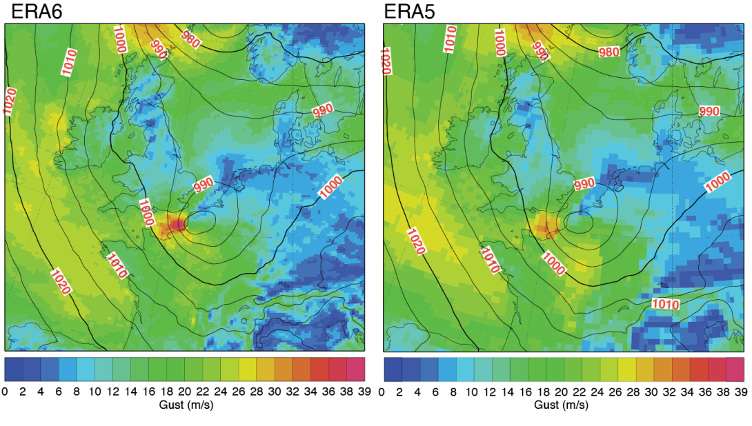
Together, these improvements will enable ERA6 to represent extreme events more accurately, as demonstrated for tropical cyclones during extended testing. Early production runs already demonstrate these improvements. One example is shown in Figure 1, which depicts Storm Egon as it crossed the Channel before reaching Dieppe at 20 UTC on 12 January 2017. Egon caused about €200 million in damage across France, Belgium and Germany. ERA6 produced stronger maximum gusts than ERA5, with values closer to observations: 38.7 m/s compared with 32.7 m/s in ERA5 and an observed maximum of 40.6 m/s.
Delivering ERA6 at scale
Delivering a complex project such as ERA6 has required close alignment across ECMWF and its partners. ERA6 production is organised into parallel ten-year streams, each preceded by a one-year spin-up to reduce discontinuities from long-memory components of the Earth system. Each stream is monitored closely and is expected to take slightly more than a year to complete. In the coming months, the streams from 1987 and 1997 will start alongside the already-running streams from 2007 and 2017. From that moment onwards, four streams will run in parallel, eventually extending ERA6 back to at least 1950. ERA6 will replace ERA5T (timely updates) after sufficient data have been published. Further timing details will be provided in future communications as part of the transition plan.