

Author: Ilaria Parodi
Weather forecasts depend on observations gathered from all around the globe.
Every day, measurements from surface stations, upper-air soundings, ships, aircraft and satellites are exchanged internationally and fed into weather prediction systems.
Yet many parts of the global observing network remain under-resourced, affecting not only local forecasting capabilities but also the quality of forecasts worldwide because weather systems do not respect national borders.
Filling these gaps has been one of the aims of the Systematic Observations Financing Facility (SOFF), a United Nations initiative established by the World Meteorological Organization (WMO), the United Nations Development Programme (UNDP) and the United Nations Environment Programme (UNEP).
As a SOFF Knowledge partner, ECMWF has supported participating countries (WMO national meteorological and hydrological services (NMHSs) from selected countries) in a number of ways, including providing training, access to forecast data and running scientific experiments.
One outcome of that collaboration was the creation of a dedicated forecast dataset that allowed SOFF countries to use ECMWF forecast data in their own forecasting activities.
Now, that support is being extended further. Originally developed for SOFF countries, the dataset has evolved into the WMO Support Dataset, which has been available free of charge to all WMO NMHS Members since June 2026.
“Weather and climate data are a global public good. By extending access to the WMO Support Dataset to all WMO NMHS Members, we are helping ensure that high-quality forecast information can support forecasting, early warning and decision-making wherever it is needed.
"The benefits extend far beyond national borders because stronger forecasting capabilities in one region contribute to a stronger global forecasting system for everyone,” says Umberto Modigliani, Deputy Director of Forecasts.
Supporting countries through SOFF
SOFF was established to help countries overcome the financial and technical barriers that prevent them from collecting and sharing essential weather and climate observations. As a foundational element of the UN Early Warnings for All initiative, it focuses particularly on Least Developed Countries and Small Island Developing States, where gaps in observing networks are often greatest and where vulnerability to climate change is particularly high.
At the core of this work is the Global Basic Observing Network (GBON), which sets requirements for the availability and geographical distribution of essential surface-based observations, providing a baseline for the data that countries need to collect and exchange internationally. These include measurements of the most essential weather and climate variables – atmospheric pressure, temperature, humidity, wind speed, precipitation and snow depth.
The SOFF initiative has helped selected WMO countries assess gaps in their observing networks, invest in new observing capabilities and ensure that observations continue to be shared internationally over the long term.
ECMWF has previously designed and carried out impact experiments for SOFF to simulate the outcome of more observations, providing evidence for targeted investment in observing networks.
These studies found that additional surface and upper-air observations could reduce forecast uncertainty by more than 30% in parts of Africa and by up to 20% in the Pacific Islands. Importantly, the improvements were not confined to the regions where observations were added but spread across the global forecasting system.
“Better observations lead to better forecasts, which in turn strengthen early warning systems and help protect lives and livelihoods. The benefits are felt not only in the countries collecting and sharing the data but across the global forecasting system,” says Umberto Modigliani, Deputy Director of Forecasts.
Collecting and exchanging better observations is only part of the challenge, however. National meteorological services also need access to forecasting information and the tools to use it effectively.
Supporting national forecasting capabilities
To help meet this need, ECMWF developed a dedicated forecast dataset for SOFF beneficiary countries.
The dataset contains a selected set of key meteorological variables from ECMWF’s Integrated Forecasting System (IFS). It draws on a subset of IFS Set-I Ensemble control in ECMWF’s real-time data catalogue, from type analysis, and data from surface, pressure and model levels. Variables include temperature, wind, humidity, pressure and precipitation.
The data are provided at high spatial resolution (around 9 km) and offer a detailed picture of forecast atmospheric conditions. This information enables national meteorological and hydrological services to initialise and run their own limited-area models (LAMs), which produce localised forecasts for their regions.
Rather than generating an equivalent global forecast themselves, national services can use ECMWF forecast data as a foundation for their own forecasting activities and focus resources on producing local forecasts and warnings for the communities they serve.
Initially known as the SOFF dataset, the resource provided 61 SOFF beneficiary countries with access to regional datasets tailored to their geographical areas.
Extending access and supporting users
As SOFF developed and the demand for access grew, ECMWF expanded the dataset beyond its original group of beneficiaries to all WMO Members.
The dataset's increased availability reflects ECMWF’s commitment to open data and to expanding free and equitable access to high-quality numerical weather prediction data for the global meteorological community.
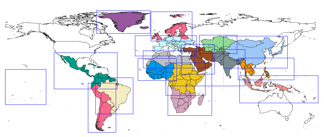
WMO Support Dataset regions
Alongside providing access to the data, ECMWF is developing supporting materials to help national meteorological services use the dataset effectively. These include documentation, example notebooks and training webinars to guide users through accessing and working with the dataset.
This global access delivers significant benefits across multiple scales. For national meteorological and hydrological services, access to high-resolution forecast data enables the development of more accurate regional and local forecasts.
This directly improves early warning capabilities for hazards such as extreme precipitation, heat waves and severe storms.
It also promotes greater equity in weather forecasting capacity. Countries with limited computational resources or observational networks can now access the same quality of initial conditions as better-resourced nations, narrowing the gap in forecasting capability across regions.
Uptake is growing, with Pakistan, Cyprus and Barbados among the most active users, while ECMWF continues to promote the dataset to encourage wider use across the WMO community.
“The WMO Support Dataset gives national meteorological and hydrological services access to high-quality forecast data that they can use to develop their own regional and local forecasts.
"This is particularly valuable for services with limited computational resources, helping them strengthen forecasting and early warning capabilities for the communities they serve,” says Victoria Bennett, Head of User Services Section.
Beyond operational forecasting, the WMO Support Dataset also supports training, research and capacity building.
Meteorological services can use the data to validate forecasting systems, strengthen expertise and develop specialised applications for sectors such as agriculture, water management and disaster risk reduction.
The work complements broader ECMWF initiatives, including Strengthening Early Warning Systems for Early Action in Africa (SEWA), which is helping countries make more effective use of weather and climate information for forecasting, early warning and decision-making.
The WMO Support Dataset is part of ECMWF’s wider work to make high-quality forecast data accessible to all WMO Members.
ECMWF provides a range of data and visualisation services to accommodate different operational needs and technical capabilities, complementing national forecasting systems and supporting the development of forecasting and climate services.
The strategic value of this initiative lies in connecting global forecasting capability with national expertise.
By supporting WMO and the national meteorological and hydrological services that turn forecast data into local warnings, ECMWF is helping narrow capability gaps and advance Early Warnings for All. It is a practical investment in international cooperation, with national services at the heart of protecting lives and livelihoods.
Accessing the WMO Support Dataset
The WMO Support Dataset is freely available to all WMO NMHS Members through ECMWF's data FTP pull dissemination system. The WMO Dataset webpage details access information and technical documentation.
ECMWF products for all WMO Members
Browse the range of products and services available to WMO Members in our brochure.