

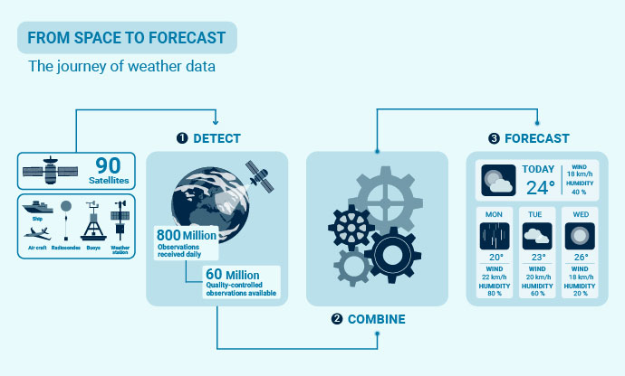
Weather observations from satellites and ground-based instruments are quality-controlled and combined in ECMWF’s forecasting systems to produce accurate weather forecasts.
Authors: Umberto Modigliani, Irina Sandu, Stephen English, Tony McNally
Every forecast starts from an estimate of the current state of the Earth system, one that is global, timely and physically consistent.
Local observations can tell us a great deal about the next few hours but forecasts several days to several weeks ahead depend on a global picture, including from oceans, deserts, polar regions and other places where surface observations are sparse. This is why satellite observations are now vital to medium-range forecasting.
Since the start of the modern satellite-observation era around 1979, the volume and value of space-based data have grown enormously. Much of this data enters ECMWF's operational Integrated Forecasting System (IFS) within hours of being measured, supporting forecasts from the medium range through to seasonal timescales, as well as services delivered through the EU’s Copernicus programme and Destination Earth initiative.
Every day, ECMWF receives around 800 million observations and makes around 60 million quality-controlled observations available for use in its IFS, most from around 90 satellite instruments. These observations cover the atmosphere, ocean, land, snow and sea ice.
Alongside satellite data, in situ observations remain essential. Measurements from weather stations, radiosondes, aircraft, ships, buoys and other observing platforms help calibrate and validate satellite instruments, detect biases, and anchor the data assimilation system. They also provide detailed local measurements that satellites cannot always capture directly. In this sense, satellite and in situ observations are complementary parts of the same observing system.
Together, these observations play a crucial role in the quality of the internationally recognised weather, environmental and climate services that ECMWF delivers to its Member and Co-operating States and users worldwide.
“Through shared scientific, computational and operational capability, ECMWF transforms global observations into trusted forecast information that no single national meteorological service could easily produce alone and use every day,” said Stephen English, Deputy Director of Research at ECMWF.
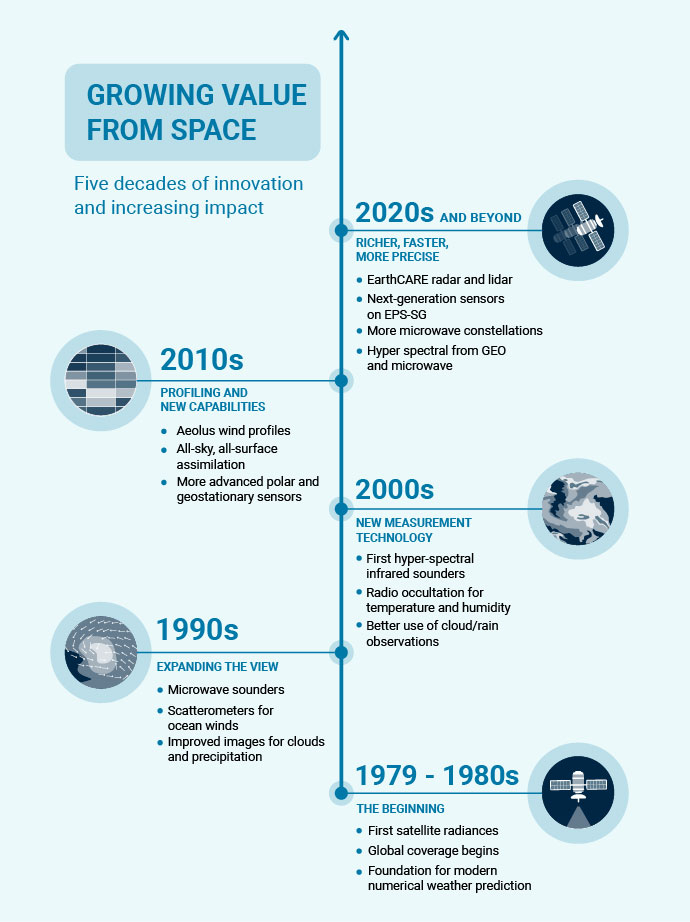
Growth in the volume of satellite observations available to numerical weather prediction since the start of the modern satellite era in 1979.
Three steps from observation to forecast
- Space agencies launch and operate constellations of satellites, carrying a variety of sensor technologies designed to measure different aspects of the Earth system. They collect, calibrate and disseminate the sensor measurements as quickly as possible over high-speed dedicated networks.
- ECMWF uses a process called data assimilation to bring together millions of measurements from satellites, as well as ground-based, airborne and marine data, to construct a coherent real-time description of the current Earth system.
- This description of the current state is then used to initialise ECMWF’s global forecast models. It also provides information that Member States can use to launch their own targeted weather, environmental and climate services.
What satellites observe
Satellites do not see a finished weather map. They detect physical signals from the atmosphere, ocean, land, snow and ice, which contain clues about the weather and the wider environment.
These signals include radiation or reflected energy that contains information about temperature, humidity, wind, cloud, precipitation, sea ice, snow, land-surface conditions and atmospheric composition. The scientific challenge is to interpret those signals correctly and translate them into usable weather information.
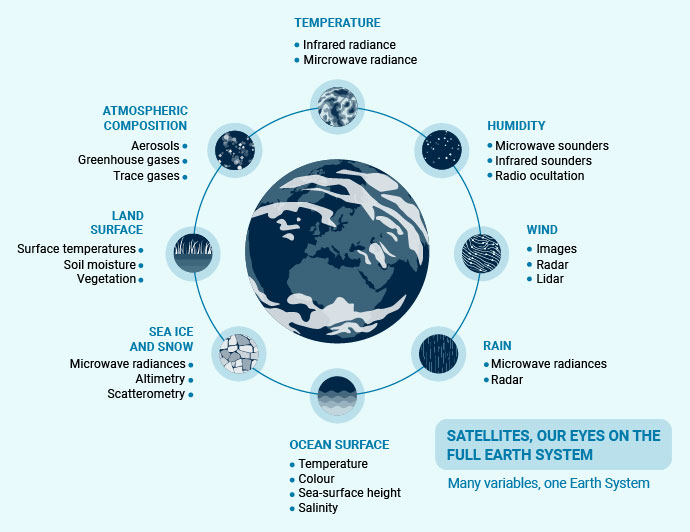
Satellite observations monitor many parts of the Earth system, providing information on the atmosphere, oceans, land, sea ice and rainfall, helping to build a complete picture of our planet.
Temperature and humidity: the backbone
Temperature and water vapour describe how energy is stored and transported in weather systems. Satellites cannot measure these directly. Instead, they use a method called spectroscopy, which identifies gases from the distinctive patterns they leave in the radiation detected by the satellite. Different gases absorb and emit radiation at different wavelengths, creating unique fingerprints. By analysing these fingerprints, satellites can provide information about temperature and humidity throughout the atmosphere.
Microwave and hyperspectral infrared instruments operated by agencies including EUMETSAT, NOAA, NASA and CMA have provided much of the backbone of the global observing system over the last 25 years. Europe is now moving towards a new generation of observing capabilities through EUMETSAT’s second-generation polar system, including the Microwave Sounder (MWS) and the Infrared Atmospheric Sounding Interferometer - New Generation (IASI-NG). The EPS-Sterna constellation, building on technology demonstrated by ESA’s Arctic Weather Satellite, is expected to provide more frequent microwave observations of temperature, humidity and clouds.
Since the mid-1990s, radio occultation has also become increasingly important. This technique uses signals from the Global Navigation Satellite System (GNSS) to infer temperature and humidity from the way the signals are delayed as they pass through the atmosphere.
Winds: seeing how the air moves
Knowing how the air moves is as important as knowing its temperature and moisture content, because wind observations reveal the dynamics of weather systems.
Some wind information comes from tracking features such as clouds or water-vapour structures in successive high-resolution images. Other instruments use active radar or lidar (laser) measurements. Scatterometers, for example, have been used since the 1990s to infer near-surface winds over the ocean from how waves and ripples scatter radar signals. More recently, missions such as ESA’s Aeolus have shown the large potential of space-based wind profiles to improve forecasts.
Clouds and precipitation: from obstacle to opportunity
Clouds and precipitation were once considered a problem for weather forecasting because they are irregular, small-scale and difficult to represent in global models.
ECMWF’s “all-sky” assimilation approach changed this by using satellite information in cloudy and rainy areas rather than discarding it. This has turned some of the most challenging observations into some of the most valuable, including radiances from microwave instruments.
New capabilities, including spaceborne radar systems such as those on the ESA-JAXA EarthCARE mission and the use of visible observations, continue to broaden what can be tested and exploited. At ECMWF, all-sky assimilation is now one of the key reasons why satellite observations contribute so strongly to forecast skill.
Surfaces: all-sky, all-surface
For many years, satellite data over land, snow and sea ice were harder to use than those over the open ocean. That has changed as Earth-system models, coupled data assimilation and machine-learning approaches have improved.
Satellites can now provide information about the Earth’s surface. Missions such as ESA’s Soil Moisture and Ocean Salinity (SMOS) and NASA’s Soil Moisture Active Passive (SMAP) provide measurements of soil moisture, while infrared and microwave imagers measure surface temperature and instruments such as CryoSat-2 and AMSR-2 provide information about snow and sea ice. These are helping forecasting move towards an “all-sky, all-surface” observing system.
These observations are also increasingly important for coupled Earth-system analyses and reanalysis, a reconstruction of past weather, including ERA6, the next-generation reanalysis currently in production at ECMWF for the EU’s Copernicus Climate Change Service (C3S).
Atmospheric composition: completing the Earth-system picture
Satellites also provide information about the composition of the atmosphere, including aerosols, greenhouse gases and other gases that affect air quality and the climate.
At ECMWF, satellite observations of aerosols, greenhouse gases and reactive trace gases play a central role in the EU’s Copernicus Atmosphere Monitoring Service (CAMS), implemented by ECMWF. These observations contribute to global analyses and forecasts of atmospheric composition, including air quality, wildfire smoke, dust and greenhouse gases.
How ECMWF leverages satellite observations
Once satellite signals have been interpreted, ECMWF combines them with a short-range forecast to create the best possible starting point for the next prediction.
This step is called data assimilation. Put simply, it combines a first guess of the current weather with new evidence from observations.
ECMWF uses a method called four-dimensional variational data assimilation (4D-Var). This method draws on observations distributed in space and time to adjust a short-range forecast while respecting the physical laws governing the atmosphere, ocean, land and ice.
The result is an analysis - the best estimate of the current state of the Earth system, and the starting point for the next forecast. Without data assimilation, forecast skill would quickly decline, eventually becoming little better than an estimate based on local climate values.
ECMWF implemented 4D-Var in 1997 and has continued to develop the system ever since. It has been a core strength of ECMWF’s IFS for decades and is central to making effective use of satellite observations across prediction timescales.
The value of satellite data also depends on the underlying science, modelling and computing needed to interpret them correctly — including how radiation travels through the atmosphere, bias correction, quality control, uncertainty estimation and the assimilation algorithms that decide how each observation should influence the forecast. ECMWF continuously evaluates data from new satellite instruments and works closely with space agencies to identify data-quality issues and bring beneficial observations into operational use.
The impact of an observing system is assessed not by the volume of observations alone, but by the difference it makes to forecast quality. Researchers test this, comparing forecasts made with and without a given type of observation to see whether a forecast improves.
These tests show that microwave radiances and radio occultation observations are particularly important for defining large-scale temperature and humidity conditions. They also show that numerical weather prediction systems, including ECMWF’s IFS, still need more wind information, a point demonstrated by the impact of ESA’s Aeolus mission during its four-year lifetime.
How AI could help use observations better
Artificial intelligence (AI) is opening new ways to use observations more completely and efficiently. Reanalysis datasets are a key training resource for AI models because they provide a consistent picture of past weather. Models trained on ERA5, ECMWF’s global reanalysis produced for the EU’s Copernicus Climate Change Service (C3S), have already proven highly successful.
AI could also help emulate parts of the observation-processing chain, improve quality control, learn complex observation operators — the tools that convert model variables into the form of an observation, or help relate observations to model variables — and accelerate the route from raw measurement to forecast impact.
For example, an AI system might learn that a subtle pattern in microwave signals often points to developing moisture or cloud structures, or might identify suspect observations before they enter the forecast system. In practical terms, this could help systems spot useful patterns faster, flag doubtful data earlier, and learn more efficient ways to turn observations into information that improves forecasts.
The opportunity is not to replace the observing system, but to amplify its value, making better use of existing measurements, preparing for the next generation of missions, and helping forecast systems learn from decades of carefully curated Earth-system data.
This is where developments such as Artificial Intelligence – Direct Observation Prediction (AI-DOP) can become important, by connecting satellite observations, data assimilation and machine learning in ways that deliver practical improvements for forecasts.
“AI-DOP is exploring whether we can make forecasts directly from the observations themselves, using machine learning to identify patterns in how the atmosphere evolves,” said Tony McNally, Head of Earth System Assimilation.
Delivering value now and in the future
ECMWF’s role is not simply to receive satellite data, but first and foremost to turn those data into forecast information that can be used by Member and Co-operating States, national meteorological and hydrological services, Copernicus services and other users.
For Member and Co-operating States, this shared capability is a strategic asset. ECMWF brings together scientific expertise, high-performance computing, operational data assimilation, forecast evaluation and partnerships with space agencies to turn global observations into reliable forecast information. This collective approach avoids unnecessary duplication, supports national forecasting services, and helps ensure that investments in observing systems translate into better warnings, services and decisions.
“The value of ECMWF lies not only in running forecasts, but in transforming shared investments in observations, science and computing into better services for Europe and beyond,” said Umberto Modigliani, Deputy Director of Forecasts.
Satellites have transformed weather forecasting. At ECMWF, they provide the vast majority of observational information behind Earth-system analyses and reanalyses, filling gaps where conventional observations are sparse, and giving a continuous view of the atmosphere and Earth’s surface used to initialise every prediction.
The next generation of satellite missions, alongside better ways of using available observations and advances in AI, will allow ECMWF to extract more value from every measurement.
“The future strategy is clear: use every observation better, combine physics and AI wisely, and ensure that new technology strengthens the trusted forecast chain from space to society,” said Stephen English.
That value reaches society through the National Meteorological and Hydrological Services of ECMWF’s Member and Co-operating States, who combine global forecast information with their own national observations, regional expertise, and trusted user relationships.
“ECMWF provides the global picture, while national meteorological services bring the local observations, expertise and knowledge of their users. Together, that turns global forecast information into decisions that protect lives, infrastructure and economies,” added Stephen English.
Whether forecasts are physics-based, AI-enabled or hybrid, their quality still depends on accurate observations and on the ability to turn those observations into useful information. In this sense, ECMWF’s contribution is both scientific and collective: helping its Member and Co-operating States turn shared observing investments into trusted forecast information and tangible benefits for society.
Further reading
Eyre, J. R., S. J. English & M. Forsythe, 2020: Assimilation of satellite data in numerical weather prediction. Part I: The early years. Quarterly Journal of the Royal Meteorological Society, 146, 49–68. https://doi.org/10.1002/qj.3654
Eyre, J. R., W. Bell, J. Cotton, S. J. English & M. Forsythe, 2022: Assimilation of satellite data in numerical weather prediction. Part II: Recent years. Quarterly Journal of the Royal Meteorological Society, 148, 521–556. https://doi.org/10.1002/qj.4228
Moran, E., T. Mohr, F. Rabier, J. R. Eyre & J. Saalmüller, 2026: From imagery to impact and beyond: Four decades shaping the future of national meteorological and hydrological services. Journal of the European Meteorological Society, 5, 100048. https://doi.org/10.1016/j.jemets.2026.100048