

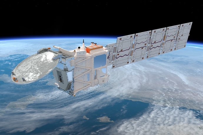
Credit: ESA/ATG medialab
New cloud radar data from the ESA-JAXA EarthCARE (Earth Clouds, Aerosols and Radiation Explorer) satellite mission is being assimilated into ECMWF’s global forecasting system – the first time any operational forecasting centre has assimilated this type of data.
The new observations, from the cloud profiling radar (CPR) onboard EarthCARE, provide an unprecedented view of the vertical structure of clouds and precipitation across the globe. Incorporating this information into the Integrated Forecasting System (IFS) will help to improve its forecasts.

How EarthCARE’s cloud profiling radar (CPR) data is assimilated into the IFS. The CPR returns detailed profiles of vertical cloud structure and precipitation intensity. ECMWF ingests EarthCARE’s radar reflectivity data, along with millions of other observations, in the numerical weather prediction model to update the current state of the atmosphere. The improved estimate of the atmospheric state in the model drives more accurate future weather forecasts and timely warnings. Credit: ESA/JAXA/ECMWF
Although some information on the structure of clouds has been included for several years from microwave imagers and sounders, the activation of EarthCARE earlier this month, marks the first operational use of cloud radar observations directly within ECMWF’s data assimilation system.
Florian Pappenberger, ECMWF Director-General, said: “This is the first operational assimilation of cloud radar observations by any weather forecasting centre.
"The new data from the Cloud Profiling Radar on the joint ESA-JAXA EarthCARE mission is a crucial step for reducing uncertainties in how clouds influence the weather, and as ever, international collaboration has been at the heart of EarthCARE.
"Scientists at ECMWF have been working with ESA and JAXA engineers to ensure the best data quality and we also have our partners at the Dutch national meteorological service KNMI and McGill University, Canada to thank, along with the many others involved in bringing EarthCARE to fruition.”
ESA’s Director of Earth Observation Programmes, Simonetta Cheli, added: “This is the result of years of dedication, expertise and collaboration from the many scientists, engineers and mission teams across the world.
"It is also thanks to JAXA, whose contribution of the cloud profiling radar has been key to the mission’s success. Our thanks go to ECMWF and all who have worked tirelessly to ensure that data from the cloud profiling radar can be assimilated into their forecasting system – a huge amount of consideration and preparation has led to this important milestone.”
JAXA’s EarthCARE Mission Scientist, Takuji Kubota commented: “ECMWF’s initiatives in collaboration with the ESA are expected to improve the accuracy of forecasts for extreme weather events such as typhoons and heavy rainfall, and to strengthen early warning capabilities for floods and landslides.
"Through these disaster prevention and mitigation efforts, we greatly welcome their contribution to building a safer and more secure society – not only in Europe, but also in Japan."
Clouds are a key source of uncertainty in weather forecasting, so being able to observe both their location at the time of measurement and simulate how they will evolve over time, has a significant impact on the overall accuracy of a forecast.
Providing a unique view
EarthCARE was launched in May 2024 as ESA’s eighth Earth Explorer mission, in collaboration with JAXA. The satellite carries four instruments designed to work together, including alongside the CPR, a high-spectral-resolution lidar, a multispectral imager and a broadband radiometer.
Together, these instruments provide a unique view of not only the vertical structure of clouds and aerosols, but also how much they reflect sunlight and absorb heat emitted from the Earth.
From research to operational forecasting
EarthCARE was originally designed as a research mission to improve scientific understanding of clouds, aerosols and precipitation.
Mark Fielding, who leads the EarthCARE assimilation project at ECMWF, said: “Bringing cloud radar observations that reveal the vertical profiles of cloud and rain into the IFS is an exciting new development for weather forecasting.
"EarthCARE was not originally designed for operational forecasting, so realising this additional benefit is a real bonus on top of the scientific understanding that the new observations are giving us”.
Simulating EarthCARE observations
Before observations can be assimilated into weather forecasts, ECMWF must simulate how the satellite instruments would "see" the atmosphere based on model variables such as temperature, humidity and cloud content. For EarthCARE, this is done using a radiative transfer model to mimic the reflectivity of radar waves passing through the atmosphere and then scattering off cloud, rain and snow.
The ability to simulate EarthCARE observations also enables continuous monitoring of data quality. Within days of the satellite’s instruments being switched on, ECMWF began assessing their performance in near real time and providing feedback to ESA and JAXA teams. This has supported calibration improvements and ensured the high quality required for operational use.
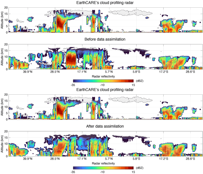
Before and after assimilating EarthCARE cloud profiling radar data on 10 June 2026, the day EarthCARE was activated in the operational assimilation system. The top panel shows EarthCARE radar reflectivity observations, while the bottom panel shows simulations from the model forecast before and after assimilation.
Improving forecasts by better representing clouds
The new observations provide detailed constraints on cloud processes, such as whether a cloud is composed of ice or liquid, the amount of water it contains, the size of particles and how quickly they fall. These insights are helping scientists refine how clouds are represented in the forecasting model.
Nine months of testing have shown a modest positive effect on short- to medium-range forecasts, particularly for humidity and wind fields, with improvements most noticeable in the Southern Hemisphere.
Interestingly, the strongest forecast impact is seen in winds. This is linked to the so-called “tracer effect”, whereby cloud-related observations help position air masses more accurately in the model, improving the large-scale atmospheric dynamics that underpin forecasts.
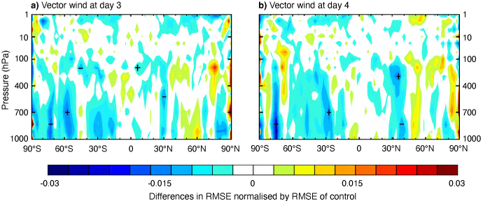
Normalised change in the root-mean-square error (RMSE) of five-day forecasts, measured against own analysis, of (a) vector wind at day 3 and (b) vector wind at day 4 when assimilating EarthCARE observations in addition to operationally assimilated observations, relative to control experiments without EarthCARE observations. The experiments were performed on forecasts from 1 December 2024 to 31 August 2025. Cross-hatching indicates 95% confidence.
New insights into extreme weather
EarthCARE is already providing unique case studies. In September 2025, the satellite flew directly over the eye of Hurricane Humberto, capturing a space-based view of the vertical motion of wind, rain and snow within the eyewall – something not previously observed.
These insights are helping ECMWF scientists to improve how cloud processes are represented in our weather model and ultimately how realistic weather forecasts are.
Rebecca Murray-Watson, a scientist at ECMWF who works with the EarthCARE data in the IFS, said: “As a cloud physicist, what excites me the most about EarthCARE is the Doppler radar – for the first time we have a satellite that can tell us not just where the ice is, but how fast it's falling.
"That kind of information is exactly what drives improvements in the next generation of weather models. Being able to sit down with the EarthCARE data and compare it directly against our model simulations tells us where we're getting things right, and where there's still work to do. Furthermore, improved understanding of physical processes can also ultimately help to inform climate projections carried out by the wider weather and climate community."
Preparing for the next generation of observations
The operational use of EarthCARE marks a milestone in the use of active satellite observations in numerical weather prediction.
Unlike conventional satellite data, cloud radar and lidar provide direct information on the vertical structure of clouds and precipitation, which is especially important in dynamically active – and often high-impact - weather systems where clouds strongly influence atmospheric heating, radiation and precipitation processes.
The new capability complements ECMWF’s existing use of all-sky assimilation of microwave observations and opens the way for future use of advanced cloud-profiling operations in operational forecasting systems.