Datasets

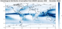
Standalone ecWAM wave model CY50R1 forced by corrected ERA5 hourly neutral 10m winds, air density, gustiness and sea ice fraction (2024-2025). Native grid is Tco799 (14km), 36 directions, 36 frequencies. Altimeter wave data assimilation,See Bidlot et al. 2026: Wave Hindcast for ERA6 Preparation and Training Data Driven Models. ECMWF Tech Memo, in preparation, Hourly output, many parameters.
Interval/period: N/A
Interval/period: Tue, 01/01/2002 - Sat, 12/31/2022

Note: This Generation 1 Collection has been superseded by Generation 2 Simulation-level Collections
Interval/period: N/A
The DestinE Digital Twin for Climate Change Adaptation (Climate DT) supports adaptation activities by providing innovative climate information on multi-decadal timescales, globally, at scales at which many impacts of climate change are observed. It combines cutting-edge global Earth-system models, impact-sector applications and observations into a unified framework to provide global climate projections and impact-sector information on multi-decadal timescales (1990 to ~2050), at very high spatial resolutions (5 to 10 km).
Interval/period: N/A

Interval/period: N/A

Interval/period: Mon, 01/01/1940 - Fri, 12/31/2100

Interval/period: N/A
Interval/period: Mon, 01/01/1979 - Mon, 06/30/2025

Cloud base height is derived by upwardly searching the structure of the model atmosphere to find the altitude where the cloud fraction becomes >1% and...
Interval/period: N/A