Datasets
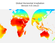
irradiation, as well as direct normal irradiation, on a latitude/longitude grid
covering land surfaces and coastal areas of Europe, Africa, Oceania, Eastern
South America, the Middle East and South-East Asia. It is created from 15 minute
resolved timeseries at each grid point. These timeseries were calculated by the
CAMS Solar Radiation Time Series Service and use information on aerosol, ozone
Interval/period: Sat, 01/01/2005 - Sun, 12/31/2023

Interval/period: Sat, 09/01/1984 - Thu, 07/31/2025
Interval/period: N/A

Interval/period: Sun, 01/01/1950 - Wed, 12/01/2100
Interval/period: Thu, 10/18/2018 - Wed, 07/31/2019

Interval/period: Sun, 01/01/1950 - Fri, 12/31/2100

Interval/period: Mon, 01/01/1940 - Fri, 12/31/2100

Interval/period: N/A
Interval/period: Tue, 01/01/2013 - Tue, 12/31/2024
Interval/period: Sun, 01/01/1950 - Sat, 07/04/2026
LAPrec1871 starts in 1871 and is based on data from 85 input series;
LAPrec1901 starts in 1901 and is based on data from 165 input series.
Interval/period: Sun, 01/01/1871 - Sat, 07/04/2026
ECV datasets provide the empirical evidence needed to understand the current climate and predict future changes.
CIIs contain condensed climate information which facilitate relatively quick and efficient subsequent analysis. Therefore, CIIs make climate information accessible to application focussed users within a sector.
Interval/period: N/A
Interval/period: Wed, 01/01/1986 - Mon, 12/31/2085
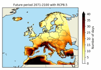
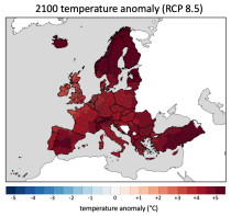
These heat wave and cold spell days are available for different future time periods and use different climate change scenarios.
Interval/period: Wed, 01/01/1986 - Mon, 12/31/2085
Interval/period: Mon, 01/01/1979 - Mon, 12/31/2018
ECV datasets provide the empirical evidence needed to understand the current climate and predict future changes.
Interval/period: N/A

Interval/period: Sun, 01/01/1950 - Tue, 12/31/2019

Interval/period: N/A
Interval/period: Thu, 10/18/2018 - Wed, 07/31/2019
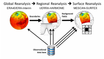
It has been generated using the UERRA-HARMONIE system by combining model data with observations into a complete and consistent dataset using the laws of physics.
Interval/period: Thu, 10/18/2018 - Wed, 07/31/2019
UERRA-HARMONIE and MESCAN-SURFEX systems. Forecasts up to 30 hours initialised
from the analyses at 00 and 12 UTC are available only through the CDS-API (see Documentation).
UERRA-HARMONIE is a 3-dimensional variational data assimilation system,
while MESCAN-SURFEX is a complementary surface analysis system.
Using the Optimal Interpolation method, MESCAN provides the best estimate of daily accumulated precipitation
Interval/period: Thu, 10/18/2018 - Wed, 07/31/2019

combined with observations using the UERRA-HARMONIE system and MESCAN-SURFEX system.
UERRA-HARMONIE is a 3-dimensional data assimilation system, whereas
MESCAN-SURFEX is a complementary surface analysis system. In general, the
assimilation systems are able to estimate biases between observations and to
sift good-quality data from poor data. The laws of physics allow for estimates
Interval/period: Thu, 10/18/2018 - Wed, 07/31/2019

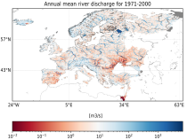
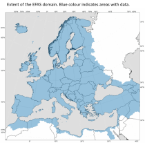
River discharge
Volumetric soil moisture
Snow water equivalent
Soil wetness index (root zone)
Runoff water equivalent (surface plus subsurface)
Interval/period: Wed, 10/14/2020 - Sat, 07/04/2026
River discharge
Volumetric soil moisture
Snow water equivalent
Soil wetness index (root zone)
Runoff water equivalent (surface plus subsurface)
Interval/period: Fri, 01/01/1999 - Sat, 07/04/2026
Interval/period: Thu, 01/01/1976 - Fri, 12/31/2100