

ECMWF news highlights in the first seven months of 2021 include an upgrade of ECMWF’s Integrated Forecasting System that improved forecasts; projects and workshops to drive forward weather science; and new developments regarding the EU-funded Copernicus services implemented by ECMWF.
Better forecasts
An upgrade of ECMWF’s Integrated Forecasting System (IFS) to Cycle 47r2 implemented on 11 May introduced single precision for high-resolution and ensemble forecasts (HRES and ENS) and increased the vertical ensemble resolution.

Eight-day tracks of Hurricane Laura from 12 UTC on 22 August 2020 in high-resolution deterministic forecasts with double precision (red) and single precision (blue) along with those from the operational ensemble at the time.
The increase in vertical resolution from 91 to 137 levels was applied to all ENS forecasts in the medium to the extended range.
There were statistically significant improvements to many ENS scores of about 0.5–2% throughout most of the free troposphere, and stratospheric temperature scores were typically improved by 5 to 20%.

Zonal (east–west) means of mean temperature errors at a lead time of 10 days in the ensemble control forecasts of the previous cycle, 47r1 (left), and the new cycle, 47r2 (right). More saturated colours indicate statistical significance at the 5% level. The evaluation was carried out over all forecasts starting between 25 Nov 2019 and 28 Feb 2020, and between 5 Oct 2020 and 7 Nov 2020.
ECMWF users were updated on all these developments and more during this year’s Using ECMWF’s Forecasts event (UEF2021) from 1 to 4 June 2021. The meeting, held virtually because of COVID-19, attracted people from all over the world to discuss and provide feedback on ECMWF products and services.

The theme of UEF2021 was ‘Weather in extraordinary circumstances’.
Driving forward weather science
In January 2021, we launched ECMWF’s Strategy 2021–2030, which will guide our activities over the next ten years. The emphasis is on providing ever more skilful forecasts to our Member and Co-operating States and users around the world.

Image: © Nastco/iStock/Getty Images Plus
A change in ECMWF’s seasonal prediction system SEAS5 reduced the underprediction of tropical storms seen for the last few years.

Frédéric Vitart had a key role in changing the seasonal prediction system SEAS5 to reduce the underprediction of tropical storms.
On 5 March, ECMWF presented EU plans to develop a high-precision digital model of our planet. The initiative is called Destination Earth (DestinE). Its purpose is to create digital twins of the Earth that will make it possible to interactively explore various natural processes and human activities.

Some 170 scientists from around the world presented recent progress and challenges ahead in ocean data assimilation in a virtual event from 17 to 20 May 2021.

ECMWF is to ingest data from Saildrone uncrewed surface vehicles (USVs) later this year to improve our understanding of the behaviour of the Gulf Stream and its influence on weather.
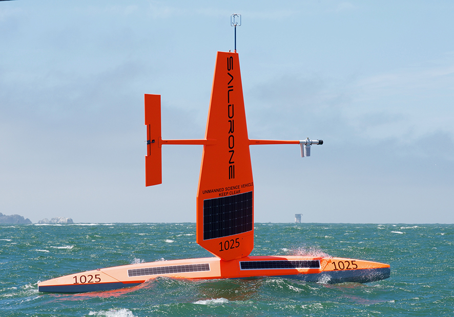
Saildrone USVs carry a wide range of sensors measuring meteorological, oceanic and environmental parameters. (Photo: Saildrone, Inc.)
In a recent concerted effort, ECMWF researchers have used detailed soil and weather observations up to about 200 metres above ground from several observational super-sites in Europe to assess different aspects of our weather forecasts.

The facility in Falkenberg, Germany, is one of the sites from which observations have been used to assess the performance of ECMWF forecasts. (Photo: German national meteorological service, DWD)
ECMWF needs up-to-date satellite observations of weather-related variables. EUMETSAT will launch geostationary and polar-orbiting satellites over the next few years that provide some innovative capabilities, including the first infrared soundings from geostationary orbit.

EUMETSAT is to launch new geostationary and polar-orbiting satellites over the next few years. (Images: ©EUMETSAT)
ECMWF’s Copernicus services
ECMWF has signed an agreement with the European Commission to continue implementing the EU-funded Copernicus Climate Change Service (C3S) and Copernicus Atmosphere Monitoring Service (CAMS) for the next seven years.

ECMWF will also continue as the computational centre for the hydrological forecasting activities of the EU-funded Copernicus Emergency Management Service (CEMS) until 2027.

The disastrous flood which hit several European countries in July 2021 illustrates the importance of EFAS as a critical European tool to forecast flooding events. (Photo of Erfstadt-Blessem, Germany – credit: Rhein-Erft-Kreis)
In April, the EU-funded Copernicus Climate Change Service (C3S) implemented by ECMWF produced a comprehensive overview of last year’s European climate.

Surface air temperature for 2020, shown relative to the 1981–2010 average. Data source: ERA5 reanalysis. Credit: C3S/ECMWF.
And a European programme to build a monitoring and verification support capability for global emissions of carbon dioxide (CO2) related to human activities entered a new phase in January to deliver a prototype system by the end of 2023. The future European support capability is expected to be part of the EU-funded Copernicus Atmosphere Monitoring Service (CAMS) operated by ECMWF.

The CO2 monitoring capability will be supported by up to three satellites (Image copyright: OHB).
Other news articles
More reports can be found on the News page of the ECMWF website.