
An upgrade of ECMWF’s Integrated Forecasting System (IFS) to Cycle 47r2 implemented on 11 May has introduced single precision for high-resolution and ensemble forecasts (HRES and ENS) and increased the vertical ensemble resolution.
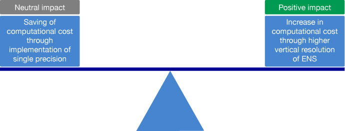
The change from double precision (64-bit accuracy) to single precision (32-bit accuracy) in many of the calculations carried out for forecasts is neutral in terms of performance, but it frees up about 40% of computing power for improvements.
The increase in ENS vertical resolution from 91 levels to the current HRES vertical resolution of 137 levels is such an improvement: it changes a broad range of forecasts for the better.

The changes come ahead of a more substantial upgrade to be introduced once ECMWF’s new supercomputer in Bologna, Italy, is up and running.
Single precision
Recent versions of the IFS have used double precision, where each number is stored using 64 bits of memory. This is often more accurate than required in view of observational errors and model approximations.
Single precision, in which each number is stored with 32 bits of memory, offers the prospect of freeing up memory and increasing computer speeds.
A few model processes, such as matrix inversion, still require double precision, and double precision is still used to establish the initial conditions for forecasts.
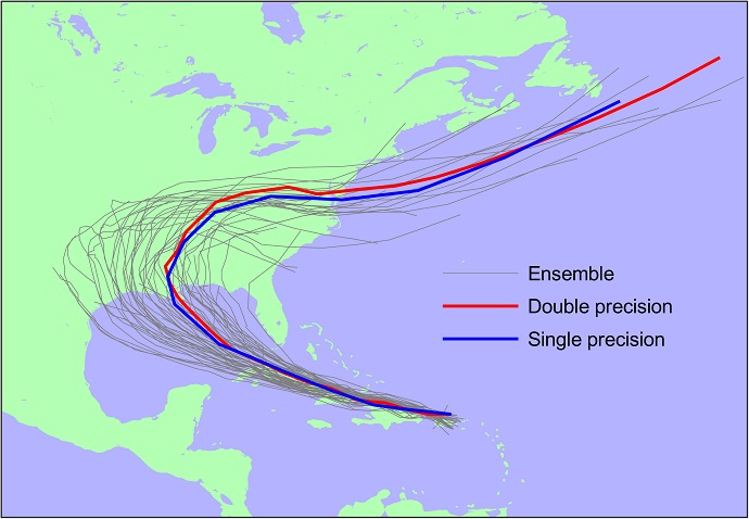
Extensive testing of the new single precision system has shown that the impact on forecasts is negligible. This is illustrated below by track forecasts of Hurricane Laura, which display considerably smaller differences between double and single precision than the range of the operational ensemble.

Eight-day tracks of Hurricane Laura from 12 UTC on 22 August 2020 in high-resolution deterministic forecasts with double precision (red) and single precision (blue) along with those from the operational ensemble at the time.
Greater vertical resolution
The increase in vertical resolution from 91 to 137 levels has been applied to all ENS forecasts in the medium to the extended range.
It leads to statistically significant improvements to many ENS scores of about 0.5–2% throughout most of the free troposphere.
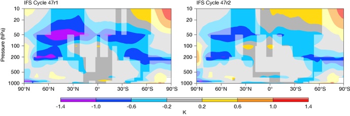
Stratospheric temperature scores are greatly improved, typically by 5 to 20%. This is illustrated by the ten-day forecast errors shown in the figure.

Zonal (east–west) means of mean temperature errors at a lead time of 10 days in the ensemble control forecasts of the previous cycle, 47r1 (left), and the new cycle, 47r2 (right). More saturated colours indicate statistical significance at the 5% level. The evaluation was carried out over all forecasts starting between 25 Nov 2019 and 28 Feb 2020, and between 5 Oct 2020 and 7 Nov 2020.
The improvement is due to a weaker growth of temperature biases because the ENS can better resolve gravity waves in the vertical. This improvement persists into the extended range.
The mean cooling difference below 600 hPa in the tropics acts to decrease the warm bias around 850 hPa in previous forecasts (increasing medium-range scores by over 6%), but it also slightly increases the cool near-surface bias.
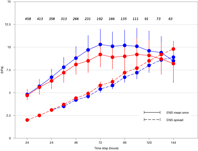
Improvements are also noticeable in tropical cyclone forecasts, where intensity errors are reduced.

Root mean square errors in the ensemble mean of tropical cyclone (TC) intensities, along with the standard deviation (spread) of TC intensities amongst the ensemble members (blue = 47r1, red = 47r2). Results are based on all TC basins for the periods of 25 Nov 2019 to 28 Feb 2020 and 10 May 2020 to 30 Nov 2020. The numbers at the top of the panel indicate the number of TCs which could be evaluated at each lead time.
The reduction in the central pressure of tropical cyclones in the medium range by about 2 hPa goes hand in hand with increased spread and improved reliability as measured by the spread–error agreement.
In the extended range, a key source of sub-seasonal predictability is the Madden-Julian Oscillation (MJO), a travelling pulse of cloud and rainfall near the equator.
In Cycle 47r2, the amplitude of the MJO is better sustained, and there is an increase in the spread of the MJO. These changes come mostly from improvements in tropical zonal (east–west) winds at 200 hPa.
Conclusion
The change to single precision in the HRES and ENS systems has freed up computing resources. This has been used to increase the vertical resolution of ENS, which has enhanced many aspects of forecast skill across different time ranges.
For more information, see the implementation page for IFS Cycle 47r2.