
Landspouts are not usually the first weather hazard that comes to mind when you think of Indonesia, where heavy rainfall and flooding are far more familiar.
Yet these tornado-like events, known locally as Puting Beliung, have been reported across the country.
One striking example occurred in Rancaekek, West Java, on 21 February 2024, damaging 503 buildings and injuring 33 people along a damage path of about 4 km and 50 m wide (Kiki et al., 2026). It was one of the most damaging tornadoes ever documented in Indonesia.
But what kind of tornado was it? How do tornadoes in Indonesia differ from those in the mid-latitudes, and under what conditions do they typically occur?
As part of my WMO Fellowship, we set out to investigate these questions in three steps. First, we compiled reported tornado cases in Indonesia from a range of sources, including scientific literature, news reports, and social media; second, we examined the atmospheric conditions associated with their occurrence; and third, we compared these environments with tornado environments in Europe.
What kind of tornado is Puting Beliung?
When we talk about tornadoes, many Indonesians may picture the large, destructive storms commonly seen in the United States with violent funnels coming from towering supercell thunderstorms and extremely strong winds and often large hail.
But is the rotating wind of Puting Beliung produced by the same process? Tornado genesis can in fact follow different pathways. Some are associated with a rotating supercell storm, while others develop without a supercell. In Indonesia, the evidence points to the latter: non-supercell tornadoes (NSTs).
Indonesia's tropical environment is generally unfavourable for supercells, largely because of the relatively weak vertical wind shear, and there is currently no documented evidence linking Indonesian tornadoes to supercell activity.
Unlike supercell tornadoes, NSTs develop without a parent mesocyclone. They instead originate from small vortices already present at the ground, known as misocyclones, which are stretched upward by a developing convective updraft and connect to the cloud base, typically while a cumulus cloud is still growing.
When this occurs over the land, as it did in Rancaekek, the resulting vortex is called a landspout; the same process over water produces a waterspout.
Because NSTs lack the visible wall cloud and radar-detectable mesocyclone that mark a supercell tornado, they are much harder for forecasters to spot or predict, which in turn makes early warning difficult.
Conditions for non-supercell tornado development
An important question is: under what conditions do NST develop?
Studies have shown that NSTs often form where winds converge or change direction, such as gust fronts and thunderstorm outflow boundaries, and as sea-lake breeze fronts.
However, these features alone do not produce tornadoes. Additional ingredients are needed for near-surface rotation to be stretched into a tornado.
One way of assessing these ingredients is the NST parameter developed by Baumgardt and Cook (2006), which combines atmospheric instability, low-level lapse rates, deep-layer wind shear, and surface relative vorticity.
However, the parameter was developed primarily from NST environments in the United States. Whether the same ingredients behave similarly in a tropical environment such as Indonesia remains unclear.
When and where do non supercell tornadoes occur in Indonesia?
To understand when and where NSTs occur in Indonesia, we compiled a historical database of reported events and examined their seasonal, daily and spatial distribution.
We found a clear daily cycle. Analysis of the 303 events from 1834 – 2025 with time information shows that most NSTs occur in the afternoon, peaking around 09:00 UTC (Figure 1), corresponding to 16:00 Indonesia western time, 17:00 central time, or 18:00 WIT eastern time, i.e. late afternoon and early evening.
This pattern is consistent with the daily convective cycle in the tropics, which typically peaks in intensity during the afternoon due to surface heating.
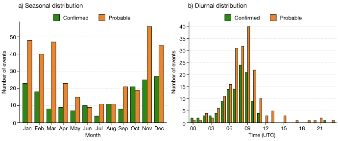
Figure 1: Seasonal (left) and diurnal (right) distribution of non-supercell tornadoes (NSTs) in Indonesia. (a) Confirmed tornado events peak during November–January, with the highest frequency occurring in December, decrease to a minimum in July, and then increase again towards the end of the year. This seasonal cycle generally follows the Indonesian rainy season, with more frequent deep convection during the wet season and reduced activity during the dry season. (b) The diurnal distribution shows a strong afternoon preference, with most landspout and waterspout events occurring between 07:00 and 10:00 UTC, peaking around 08:00–09:00 UTC or 16.00–17.00 local time.
Spatially, NST events are not evenly distributed across Indonesia. About 66% of all recorded events occurred on the island of Java (Figure 2). The high number of events in this region is likely influenced by a combination of meteorological factors and reporting bias. Coastal areas and convergence associated with the island’s mountainous terrain may favour NST formation. At the same time, Java has a high population density, increasing the likelihood that NSTs are observed and reported (Figure 2).
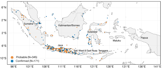
Figure 2: Spatial distribution of reported landspout-related events in Indonesia from 1834 to 2025. Colours indicate event classification as probable (orange) or confirmed (blue). The apparent concentration of events over Java may reflect both meteorological factors and regional differences in reporting. Probable events are those supported by consistent reports or eyewitness accounts but lacking sufficient visual evidence, whereas confirmed events are supported by photographs or videos clearly showing a landspout or waterspout. Source: Firdaus et al. (2025), supplemented by additional events compiled in this study.
What makes Indonesia’s NST environment favourable?
A challenge is understanding the atmospheric conditions that allow NSTs to form.
We first looked at three types of tropical wave: the Madden-Julian Oscillation (MJO), Kelvin waves, and equatorial Rossby waves – using in-house diagnostics.
Among 32 cases for which tropical-wave activity was assessed, 75% occurred while at least one of these waves was active. However, NSTs also occurred when these signals were absent or suppressed. This suggests that tropical waves may modulate the broader convective environment, but do not directly determine whether an NST develops.
We therefore analysed the atmospheric conditions immediately before an event. Using output from ECMWF’s Integrated Forecasting System (IFS), we looked at the environment around 103 confirmed NST cases, focusing on the maximum predictor values within 40 km of each location, except for convective inhibition (CIN), for which minimum value was used. These events typically occurred in environments with low to moderate deep-layer wind shear (median 8.5 m s⁻¹), substantial instability (median MLCAPE ~1900 J kg⁻¹), steep low-level lapse rates (median 0–1 km lapse rate 9.1 °C km⁻¹), and enhanced near-surface vorticity and convergence (Table 1).
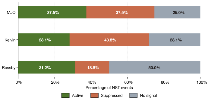
Figure 3. Distribution of tropical-wave conditions during NST events in Indonesia. Of 32 NST cases, 75% occurred with at least one wave active (53.1% one wave, 21.9% two waves; Figure 2), while 25% occurred with none active. Individually, the MJO was active in 37.5% of cases (suppressed in 37.5%, no signal in 25%), Kelvin waves in 28.1% (suppressed 43.8%, no signal 28.1 %), and Rossby waves in 31.3% (suppressed 18.8 %, no signal 50%).
Table 1: Environmental characteristics associated with NST events.
| Predictor | Typical range (P10–P90) | Median |
| Deep-layer shear (m s⁻¹) | 5.45–12.58 | 8.51 |
| 0–1 km lapse rate (°C km⁻¹) | 7.22–10.71 | 9.10 |
| 50-hPa MLCAPE (J kg⁻¹) | 1289–2721 | 1909 |
| 0–3 km 50-hPa MLCAPE (J kg⁻¹) | 113–216 | 155 |
| Surface cyclonic vorticity (×10⁻⁵ s⁻¹) | 8.90–35.31 | 17.44 |
| Surface convergence (×10⁻⁵ s⁻¹) | 9.91–33.26 | 21.57 |
| NST parameter (using relative vorticity magnitude) | 1.75–9.37 | 4.23 |
Can the predictors distinguish NST and ordinary thunderstorm?
The presence of apparently favourable ingredients does not necessarily mean that an NST will form.
This became clear when we compared the 103 confirmed NST cases with 1,033 thunderstorms for which no tornado was reported (Figure 4).
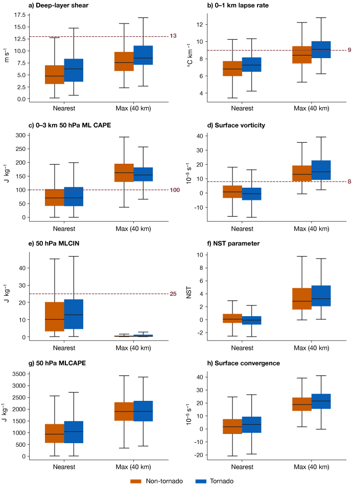
Figure 4: Distribution of eight environmental predictors for tornado and non-tornado cases in Indonesia using the IFS forecast. Orange: non-tornado cases (1,033 cases); blue: tornado cases (103 confirmed cases). The left box plots indicate the nearest grid point, and the right box plots indicate the maximum value within 40 km for all predictors except MLCIN.
Most predictors including deep-layer shear, low-level lapse rate, near-surface vorticity, convergence, and the NST parameter were slightly higher for tornado cases. The differences were somewhat clearer for surface vorticity and convergence when considering the maximum value within 40 km rather than the nearest grid point.
However, the distribution overlaps substantially while Convective Available Potential Energy (CAPE) showed little difference between the two groups.
We also checked pairwise predictor combinations and found that, at nearest grid point (Figure 5) and maximum value within 4 km (not shown), tornado and non-tornado cases occupy largely the same range conditions.
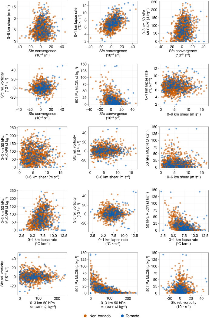
Figure 5: IFS forecast: pairwise relationship between nearest grid point environmental predictors in Indonesia (206 tornado (blue) vs. 1,033 non-tornado cases (orange).
Is Indonesia’s NST environment different from Europe’s?
After investigating Indonesia's NST environment, we were curious to see whether these predictors behave differently for cases in the mid-latitudes.
We therefore computed NST predictors for a set of European cases, using data from the European Severe Storms Laboratory (ESSL). The cases were drawn from the European Severe Weather Database (ESWD), which is maintained by ESSL, but were specifically selected by ESSL for this study using criteria based on lightning observations and model forecast and analysis data. As such, the dataset constituted a tailored set of cases designed for our investigation.
We compared Indonesia's 103 confirmed cases with Europe's 39 cases using IFS forecast data (Figure 6).
European cases showed clearly higher deep-layer wind shear than Indonesian cases. Europe's median reaches the 13 m s⁻¹ threshold at 40 km, whereas Indonesia's median is around 8.5 m s⁻¹. The 0–1 km lapse rate follows the same direction, but the gap is much smaller.
In contrast, both CAPE-related predictors, surface relative vorticity, and the NST parameter are all higher in Indonesia, most clearly at the maximum value within 40 km.
Surface convergence is the only predictor showing little difference between the two regions, at either the nearest grid point or the maximum value within 40 km.
Together, these results show that Indonesia and Europe have genuinely different tornado environments. European cases are associated with stronger shear, while Indonesian cases tend to occur in environments with greater instability.
This difference reflects the two regions’ contrasting settings. Indonesia is surrounded by warm ocean that supplies deep-layer moisture year -round, driving high CAPE. The tropics also have a weaker Coriolis effect and a small temperature gradient, so there is little large-scale forcing for strong wind shear.
In Europe, stronger temperature gradients associated with jet stream and frontal systems common at mid-latitudes generate stronger wind shear.
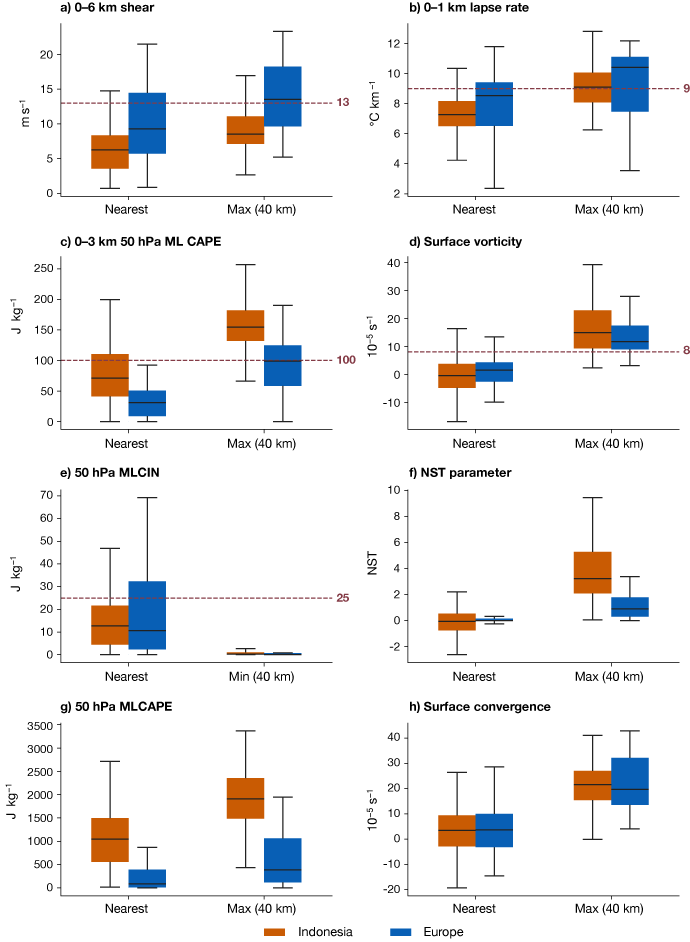
Figure 6: Comparison of eight environmental predictors for tornado cases in Indonesia (orange) and Europe (blue) using IFS forecast data.
Overall, our results show that identifying an NST environment remains challenging.
Increasing model resolution alone may not necessarily solve this problem. We tested several predictors using higher resolution runs produced with the IFS model at 4.4 km grid spacing and although the higher-resolution forecasts produced substantially stronger near-surface vorticity and convergence than the IFS did (not shown), they did not provide a clearer separation between NST and non-tornado thunderstorms.
Nevertheless, these results still provide useful guidance. By evaluating existing NST parameters for Indonesia, we can identify environmental signals that may help forecasters, while also recognising their limitations. As far as we are aware, this is also the first study to examine the climatology and environmental characteristics of NSTs across Indonesia. Future work should focus more closely on the boundaries where NSTs develop, including their movement, wind shifts and temperature gradients. Improved observations and convection-permitting models could help capture these small-scale processes. There is still much to learn, but this fellowship provides a foundation to build on. With continued research, this may help us to better understand why only some favourable environments produce NSTs and, eventually, improve the prediction of Puting Beliung.
Acknowledgements
I feel grateful and privileged to have spent the past year at ECMWF through the WMO Fellowship. I came here with many questions about non-supercell tornadoes in Indonesia, and this fellowship gave me the opportunity to explore them further. At the same time, this experience has been about more than science for me. I have learned many new things, worked with people from different backgrounds, and had opportunities to develop myself both personally and professionally.
I would especially like to thank Ivan Tsonevsky for his guidance, discussions and support throughout my research, and Becky Hemingway, my line manager, for her support throughout the fellowship.
I am also thankful to Pieter Groenemeijer from the European Severe Storms Laboratory (ESSL) for providing the European tornado data; Kiki and Agita Devi Prastiwi from the BMKG for their help with collecting and filtering the NST cases and providing synoptic observations; and Rebecca Emerton at ECMWF for her help with the tropical wave monitoring data.
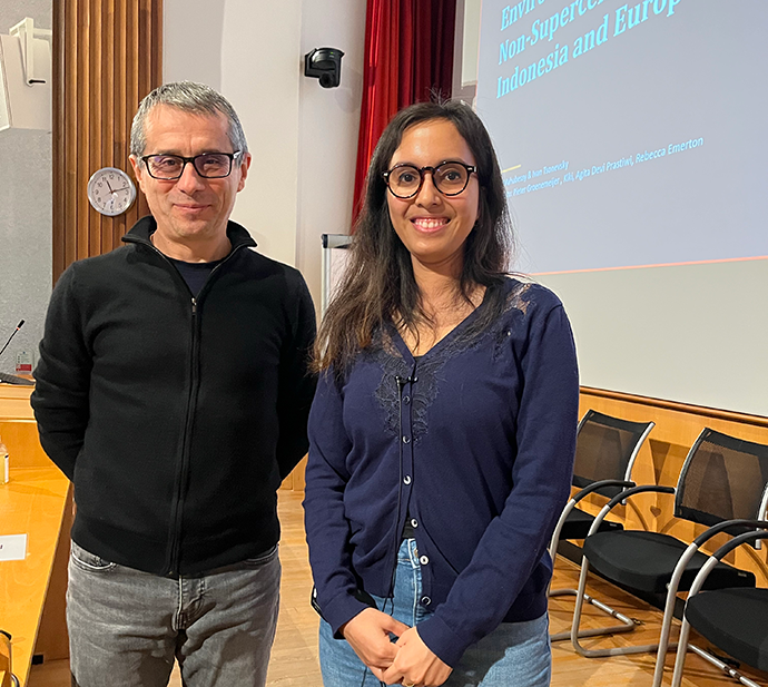
Ivan Tsonevsky and Ruth Mahubessy.