

A new publication from the Copernicus Atmosphere Monitoring Service (CAMS), implemented by ECMWF on behalf of the European Commission, shows how air pollution crossed borders and continents during the first eight months of 2026, exposing people worldwide to degraded air quality and highlighting the close connection between atmospheric composition, weather and climate.
The inaugural CAMS Atmosphere Watch publication released today provides one of the most comprehensive global assessments of the state of the atmosphere so far this year.
The publication focuses on three major transboundary pollutants: ground-level ozone, smoke from wildfires and desert dust.
It also emphasises the unique capabilities and tools of CAMS and the importance of collaboration the service has with international partners such as the World Health Organization (WHO), the Health Effects Institute (HEI), the European Environment Agency (EEA) and the World Meteorological Organization (WMO), among others, and close cooperation with national experts in the countries involved in Copernicus governance through initiatives such as the National Collaboration Programme (NCP), helping to strengthen a shared understanding of air pollution challenges worldwide.
The findings of the report show how pollutants emitted in one region can travel thousands of kilometres, affecting air quality, human health and ecosystems far beyond its source.
Florian Pappenberger, ECMWF Director-General said: “Atmosphere Watch shows that air pollution knows no border. Wildfire smoke, ozone and dust can travel thousands of kilometres, affecting communities far from their source. As the international community prepares for COP31, these findings are a timely reminder that climate change, air quality and public health are deeply interconnected challenges that require coordinated global action.
Through the Copernicus Atmosphere Monitoring Service, ECMWF is helping make informed decisions by providing the trusted data and forecasts needed to understand and respond to these growing risks.”
Laurence Rouil, Director of the Copernicus Atmosphere Monitoring Service (CAMS) at ECMWF, said: “Ozone pollution is a stark reminder of how interconnected our atmosphere, climate, health, and livelihoods really are, with pollution and our changing climate impacting the chemistry of the air we breathe, determining the health of our ecosystems, and even governing our ability to grow food.
At the same time, air pollution does not respect national borders – smoke from wildfires and biomass burning emissions, and Saharan dust plumes can travel thousands of miles to affect communities far from where they originated. This all underlines the urgent need for global-level, evidence-led action on air quality, delivering in lockstep with action on climate. This is only possible using the type of near-real-time data highlighted today by the Copernicus Atmosphere Monitoring Service.”
The report was launched at a press briefing moderated by journalist Lisa Burke with Florian Pappenberger, Laurence Rouil, Mauro Facchini, Head of Earth Observation, Directorate General for Defence Industry and Space (DG DEFIS), European Commission, Dorota Jarosińska, Coordinator Air pollution and Health impacts, WHO and Ian Marnane, Head of Unit Environment and Health, EEA.
Nearly 40% of global population have been exposed to extremely high levels of ground-level ozone
One of the most striking findings of the analysis is the scale of exposure to ground-level ozone, a pollutant that results from thousands of chemical reactions – primarily between nitrogen oxides produced mainly by fossil fuel combustion and volatile organic compounds - triggered by sunlight and high temperatures. Ground-level ozone harms human health, ecosystems and crop yields.
According to the analysis, almost 40% of the global population has been exposed to extremely high levels of ozone this year to date. In contrast, only around 5% of the world’s population experienced ozone concentrations classified as “Good” under WHO guidelines.
Despite a sustained downward trend in emissions of major air pollutants across Europe, driven by air quality legislation, particularly the European Air Quality Directive, technological advances, and cleaner practices in industry and transport, ozone remains a particularly complex global challenge influenced by temperature and solar radiation.
Half of Europe’s population was exposed to ‘Poor’, ‘Very Poor’ or ‘Extremely Poor’ ozone this year. The continent’s repeated heatwaves contributed to significant ozone exposure during the summer months – illustrating the increasingly interconnected relationship between climate extremes and air quality.
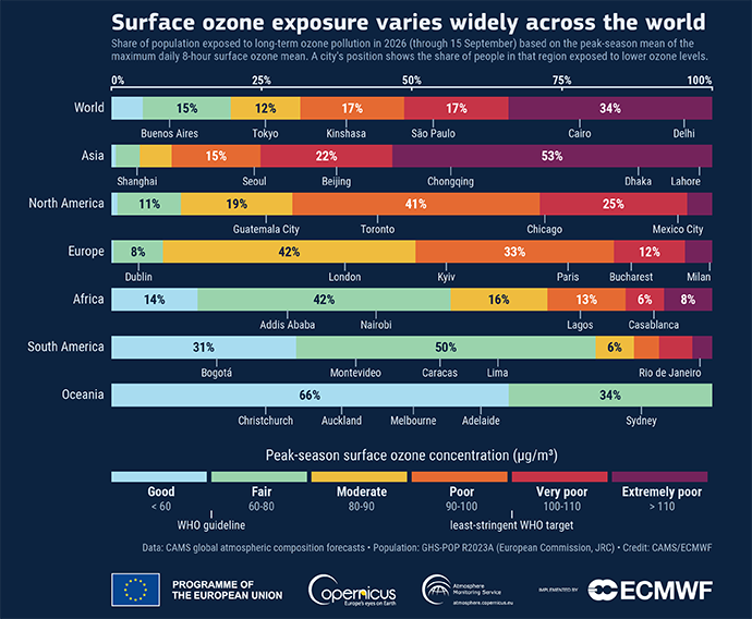
Peak-season maximum daily 8-hour ground-level ozone mean exposure by continent, with the percentage of the population and exposure in key cities indicated in micrograms per cubic metre (µg/m3). This air quality metric clearly represents the long-term exposure to ozone during the warmest and sunniest months of the year (i.e., the peak ozone season). The WHO target recommends keeping the peak-season ozone levels below 60 µg/m3. Credit: CAMS/ECMWF
Pollution and dust plumes travelling across continents
The Atmosphere Watch analysis also highlights how smoke from wildfires and biomass burning as well as desert dust travelled across continents throughout 2026.
While global biomass burning emissions have declined in recent decades, exposure to wildfire smoke is increasing as more extreme fires occur closer to populated areas. Wildfires release a wide range of pollutants, including fine particulate matter (PM2.5), nitrogen oxides and many volatile organic compounds, which also contribute to ground-level ozone formation, and greenhouse gases.
In North America, intense wildfires generated smoke plumes, some of which travelled thousands of kilometres, reaching parts of Europe and locally contributing to elevated concentrations of PM2.5.
Large fires in France, Spain, Belgium, and the United Kingdom saw intense smoke transport, leading to air quality impacts hundreds of kilometres away.
Dust from the worlds deserts is also a frequent source of air pollution. This year there were several episodes where dust from the Sahara was carried from North Africa across the Atlantic or the Mediterranean and into Europe, the Caribbean and other regions.
The findings demonstrate how air quality is influenced not only by local emissions but also by pollution transported over long distances.
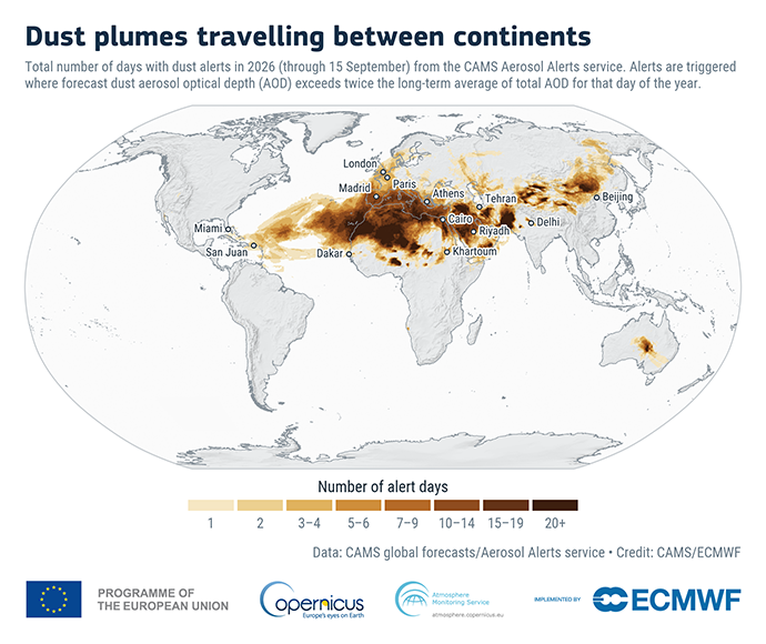
Total number of days with dust alerts in 2026 (through 15 September). Credit: CAMS/ECMWF
Supporting air quality decision making
Data from CAMS helps scientists and decision-makers track pollutants across regions and national borders, providing evidence to support air-quality management and public-health responses.
Implemented by ECMWF on behalf of the European Commission, with the contribution of more than 100 expert organisations throughout Europe, CAMS delivers near real-time data and forecasts for pollutants such as particulate matter, ozone, nitrogen dioxide and carbon monoxide, as well as greenhouse gases and wildfire emissions.
Using ECMWF’s high-performance computing facility, the CAMS global forecasting system combines observations from satellites, ground-based networks and other sources with advanced atmospheric modelling to provide analyses and short-term forecasts of atmospheric composition worldwide. By modelling more than 50 chemical species, CAMS supports the monitoring of pollution episodes, including elevated levels of ozone and particulate matter, while helping to track the movement of pollutants across continents and oceans.
This global perspective helps policymakers, researchers and public authorities better understand the drivers of air pollution and assess measures to improve air quality. CAMS regional data is also used to support national experts in the EU member states in their monitoring and reporting activities under European legislation and contributes to public awareness of air-quality issues.
Dorota Jarosińska, programme manager at the WHO European Centre for Environment, Climate Change and Health said: “Air pollution is one of the biggest environmental risks to health in Europe, linked to heart disease, stroke, lung cancer and respiratory illness. Data from the Copernicus Atmosphere Monitoring Service helps us fill the gaps between monitoring stations, especially in places where ground monitoring is sparse. That means public-health warning systems and health-risk assessments can reach people even where local data may not exist.”
Ian Marnane, Head of Unit for Environment and Health at the European Environment Agency, said: “A combination of robust ground-based monitoring, satellite data and forecasting the long-range transport of air pollutants reaching Europe is essential to support effective national and regional responses to air pollution in Europe.”