
In the next upgrade of ECMWF’s Integrated Forecasting System (IFS), changes will be implemented which improve short-range forecasts of two-metre temperature.
The improvements concern both the establishment of the initial conditions of forecasts, called the analysis, and the physics of the forecast.
The upgrade from IFS Cycle 48r1 to 49r1, which includes many other changes, is scheduled to take place in October 2024.
Initial conditions
An analysis is established by combining a previous short-term forecast with observations. The process is called data assimilation.
Currently, two-metre temperature is assimilated from SYNOP weather station reports and METAR aviation weather reports in a separate land surface analysis. This serves primarily to update initial soil moisture and temperature conditions.
However, two-metre temperature is not assimilated in the atmospheric component of the data assimilation system, 4D-Var. This will change in IFS Cycle 49r1. The change has proved beneficial after extensive testing and tuning.
Initially, tests assimilating two-metre temperature in 4D‑Var gave large improvements in short-range two-metre temperature forecasts, but in some winter regions 850 hPa temperatures were degraded. This was partly due to unrealistic coupling in stable conditions.
Consequently, the weight given to two-metre temperature data with very large departures from the short-range forecast used to establish the analysis was reduced. In addition, the assimilation of two-metre data was limited to the first 6 hours of the 12‑hour 4D‑Var window.
“With these modifications, a large benefit from this change in data assimilation is seen in northern hemisphere winter,” says ECMWF scientist Bruce Ingleby.
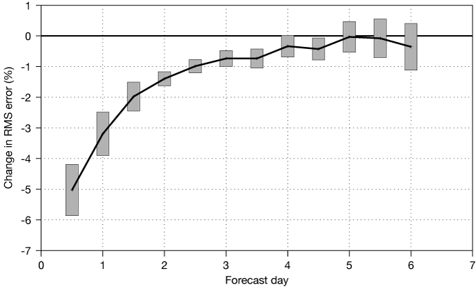
The improvement (negative) in two-metre temperature forecasts due to 4D‑Var assimilation of two-metre temperature. The plot shows results for the period of December 2021 to February 2022, for the region 20°–90°N. We show the percentage change in root-mean-square (RMS) error, verified against SYNOP observations. The grey rectangles show 95% confidence intervals.
Improvements in the separate snow data assimilation system as well as in two-metre temperature and soil moisture land data assimilation are also applied.
This includes in particular the exploitation of satellite-based snow cover information in mountainous areas. Another change is an increase in the maximum allowed snow depth value from 1.4 m to 3 m in the analysis.
“As a result, biases in the number of days with snow depth on the ground in the model are reduced, especially in mountainous areas,” says ECMWF scientist Patricia de Rosnay.
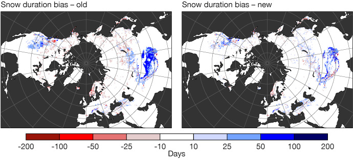
Biases of snow duration (number of days when snow depth is more than 1 cm in the model) compared to the US National Oceanic and Atmospheric Administration’s Interactive Multi-sensor Snow and Ice Mapping System (IMS) in March–May 2022 before (left) and after (right) the snow data assimilation changes. Positive biases are reduced in mountainous areas.
Physics changes
Several changes were made towards a more realistic physical representation of processes in the model.
One is the introduction of new Land-Use Land-Cover (LULC) and leaf area index (LAI) maps and the implementation of a new leaf area index disaggregation operator. The latter makes it possible to better distinguish between high and low vegetation components and results in more accurate seasonal variability of vegetation.
Other changes concern the modelling of plant roots to extract water and establishing the surface albedo of forests with snow underneath. The postprocessing of two-metre temperature was also revised to better match the theoretical profile under stable conditions.
In addition, model parameters were adjusted, for example to enable a better match of surface fluxes with in-situ observations.
“Improvements brought about by the physics changes can be seen in charts of temperature cross-sections for different latitudes and pressure levels at several forecast ranges,” says ECMWF scientist Souhail Bousseta.
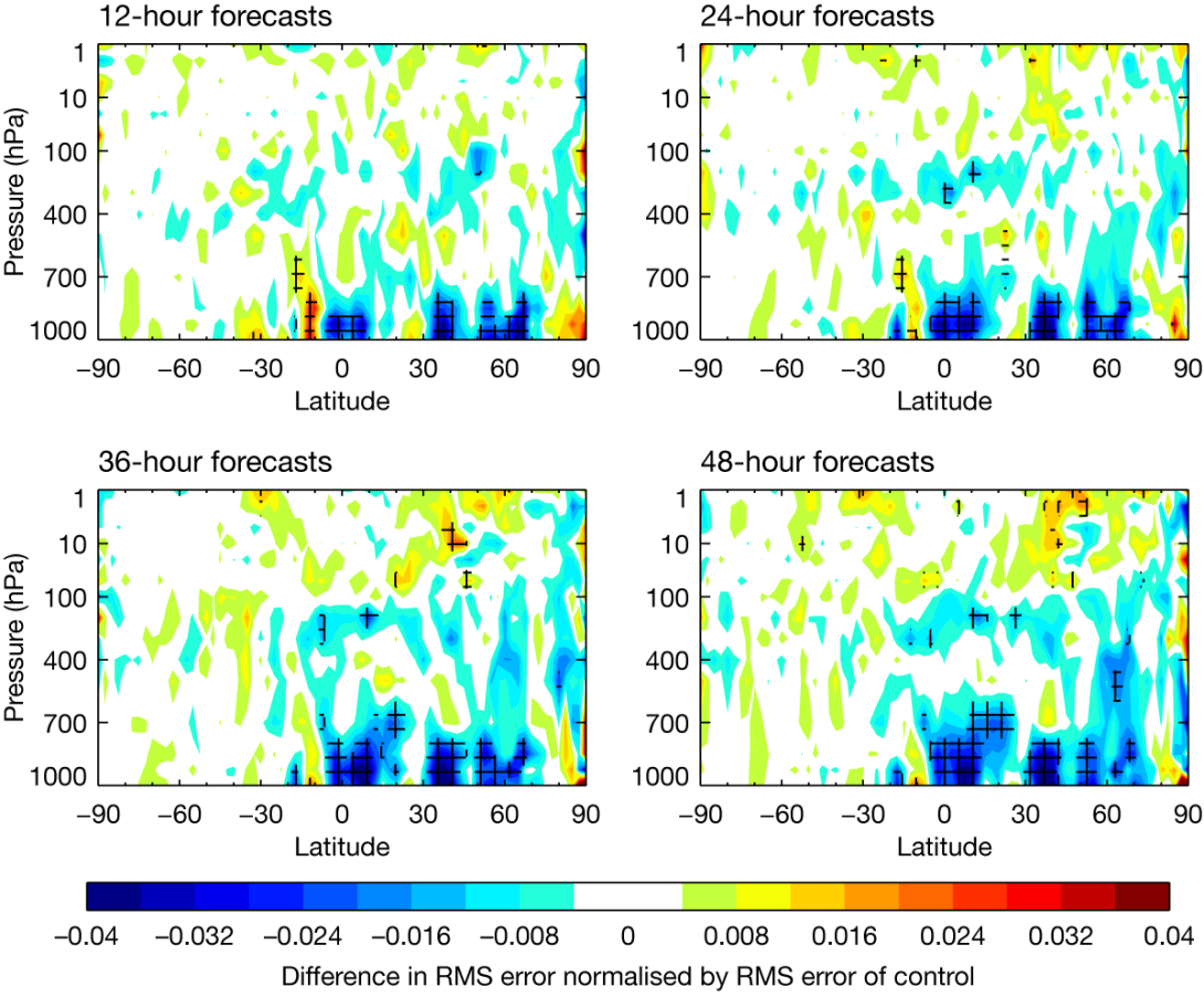
Temperature forecast improvements related to the vegetation changes and associated modifications are shown in the blue areas, which correspond to a reduction in the root-mean-square (RMS) error of the temperature forecasts. The tests were carried out from 5 June 2020 to 31 August 2020. Forecasts were verified against each experiment’s own analysis, and cross-hatching indicates statistical significance at the 95% confidence level.
Overall results
The result of all the changes set out above is improved two-metre temperature forecasts, especially in northern hemisphere winter.
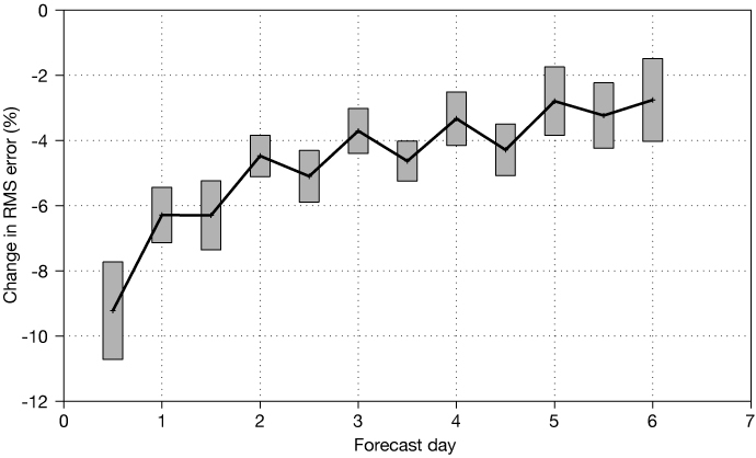
The impact of Cycle 49r1 on two-metre temperature forecasts verified against SYNOP observations (percentage change in root-mean-square error) for December 2021 to February 2022, 20°–90°N. The grey rectangles show 95% confidence intervals.
A more detailed account of the two-metre temperature improvements in IFS Cycle 49r1 is provided in an ECMWF Newsletter article.
An overview of all the improvements brought by IFS Cycle 49r1 was recently provided by ECMWF Director of Research Andy Brown.