
El Niño sea-surface temperature anomaly forecasts such as this one, issued for the NINO3.4 region on 1 November 2022 for the next seven months, are part of ECMWF’s seasonal forecasts.
What are sub-seasonal and seasonal predictions?
ECMWF issues sub-seasonal weather predictions up to 46 days ahead. They are ensemble forecasts, and they show predicted week-to-week changes in the weather. Seasonal predictions are mainly issued up to seven months ahead. They are ensemble forecasts too, and they provide expected future atmospheric, land, and oceanic conditions averaged over one to three months. The longest-range predictions issued by ECMWF are 13-month forecasts of sea-surface temperature anomalies in the El Niño region in the equatorial Pacific.
Why do we cover these time ranges?
ECMWF produces such forecasts for two reasons. The first is that there is interest in forecasts for relatively long time frames among a range of customers. For example, the production of renewable energy depends on future sunshine levels and winds over the next few weeks and months. Also, sea-surface temperatures in the equatorial Pacific are known to have a big effect on weather patterns elsewhere, so we try to forecast those as long ahead as possible. Another advantage of these forecasts is that they help challenge our forecasting systems and show where improvements are needed, benefiting our forecasts at all time ranges.
What can such predictions tell us?
Predictions longer than ten days in advance generally tell us the expected range of conditions that might occur, as represented by the ensemble members, and how these differ from normal. We usually represent the forecast as probabilities of various outcomes occurring, and we also plot the ensemble mean anomaly. This is not a prediction of what will happen but rather shows the size of the shift in the centre of the distribution of possible outcomes. We show anomalies and probabilities for time-averaged quantities, for example how predicted temperature averaged over seven days might differ from normal in three weeks’ time. The averaging period increases with lead time, typically from a week for sub-seasonal forecasts to a month or season for seasonal forecasts.

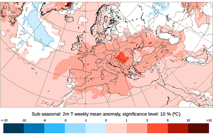
This chart from ECMWF’s publicly available catalogue shows a forecast of 2-metre temperature anomalies from 26 June for 21–28 July 2025. The shading indicates the mean predicted temperature anomaly.
How are sub-seasonal predictions produced?
Sub-seasonal predictions are produced from the same coupled ocean–atmosphere model that is used for the medium range, but at a lower resolution. An important source of predictability in this time range originates from a 30–60 day fluctuation in tropical weather, called the Madden–Julian Oscillation (MJO). The use of a coupled ocean–atmosphere system helps to capture some aspects of MJO variability. Other sources of extended-range predictability include stratospheric and soil moisture initial conditions.
How are seasonal predictions produced?
Longer-term predictions of the climate are possible because the ocean, the cryosphere and elements of the land evolve more slowly than the atmosphere. The influence of these Earth system components can be detected in the average weather over a month or season. For example, monthly average rainfall in March to May in the Nordeste region of Brazil is related to sea-surface temperatures in the tropical Pacific and Atlantic in the months before and during the rainy season. Our calculations include the increase in greenhouse gases such as carbon dioxide and methane, which has a substantial impact on our forecasts.
What does the future hold?
Sub-seasonal and seasonal predictions may become even more important in a changing climate marked by more extremes than before, and when the information provided by the climatology is no longer a good guidance. Prediction systems are updated regularly to keep up with the latest scientific developments. We are working to improve the realism of the stratosphere and the land surface in our forecasting system, since these can play an important role in predictability at sub-seasonal and seasonal timescales. We are also assessing the potential of artificial intelligence (AI) methods for improved sub-seasonal forecasts and seasonal forecasts, either by working in tandem with traditional physics-based models or by running as forecasting systems in their own right.
What does the Copernicus Climate Change Service offer?
ECMWF’s sub-seasonal and seasonal predictions are publicly available on our website. The seasonal predictions also feed into the seasonal forecast pages of the EU’s Copernicus Climate Change Service (C3S) implemented by ECMWF. These pages show seasonal forecasts for a range of parameters from eight forecasting centres, including ECMWF, and combined C3S multi-system seasonal charts.