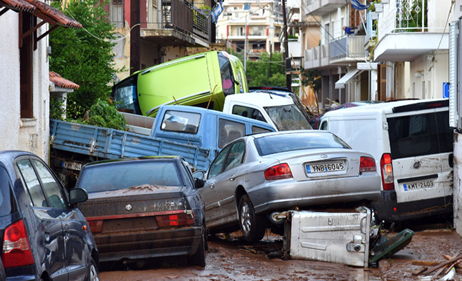
Between about midday on 6 September and midday on 7 September 2016, extreme rainfall affected parts of Greece, most notably in the southern part of the Peloponnese and also much further north, over and just south of Thessaloniki. According to media reports, the resulting flash floods caused four fatalities, invaded properties, closed roads, and caused cars to be piled up and locally swept out to sea. Rainfall reports are limited, though Kalamata airport recorded more than 130 mm in 24 hours, whilst various unofficial reports from nearby suggest 24-hour totals of the order of 200 mm, most of which fell in two or three hours. Meanwhile a report in the ESSL (European Severe Storms Laboratory) database indicates that over 300 mm fell locally near Thessaloniki.
Experience from similar extreme rainfall events suggests that spatial variability can be very high. This means that even larger amounts may have accumulated very locally in each case, even in the absence of topographic forcing. In the figure showing observed rainfall totals there is evidence of such variability near Thessaloniki and also in the high-density observations over the heel of Italy, in a relatively flat area. One current project at ECMWF aims to automatically predict the degree of sub-grid variability in precipitation totals, in recognition of how important this is to users interested in flood risk, and because raw model output provides only a grid-box average.
Synoptic situation

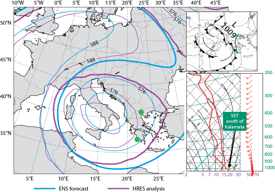
The synoptic situation over Greece on 6 and 7 September was characterised by moist and very unstable south to south-easterly flow, ahead of upper and surface low pressure systems situated to the west. The mean 500 hPa geopotential height field from the 96-hour ensemble forecast (ENS) shown in the figure is quite accurate compared to the analysis; most notably the cut-off upper vortex – the driver of the bad weather – was well positioned over southern Italy. The equivalent high-resolution forecast (HRES) for the same time (not shown) was very similar, just marginally worse. Getting features of the large-scale flow pattern reasonably correct is a necessary but not sufficient condition for accurate predictions of severe surface weather. The cold front shown in the inset was also a key player – extreme convective activity would lie on and ahead of it. In the model sounding in the second inset one can see evidence of extreme convective instability, given triggering by sea-surface temperatures of about 26°C, and the copious low-level moisture supply, both of which would help to generate very large rainfall totals.
Rainfall forecasts
The remaining figures show HRES and ENS rainfall forecasts, respectively, for a lead time of three to five days, spanning the event. This relatively long window was used to be sure to capture the passage of any extreme rainfall related to the front, and also because it is a standard time window used for the EFI/SOT (Extreme Forecast Index and Shift Of Tails) products provided to forecasters on the web. HRES shows a lot of local detail, correctly signalling a potential for very large totals around Thessaloniki. However, the forecast for Kalamata does not look that extreme relative to other areas (41 mm spot total for the town). ENS as represented by ECMWF’s extreme weather indices, on the other hand, correctly highlights both Thessaloniki and Kalamata as being at risk. The EFI is high in both locations (0.8 to 0.9), suggesting that very large rainfall totals are likely, whilst the SOT is also high (>2), suggesting that a truly exceptional event is possible. This case is a good example of the benefits of using ECMWF output and products for severe weather prediction. It also illustrates that, in the medium range at least, ENS is the main tool to use by forecasters when it comes to identifying areas at risk. HRES is more prone to provide unreliable local detail and similarly to jump between successive runs in its indications of where extreme weather may be. This is especially true when the situation is dynamically and/or thermodynamically unstable, as is the case with most severe weather events, including the one illustrated here. It is for such reasons that ensemble prediction lies at the heart of ECMWF’s new ten-year Strategy.
ECMWF acknowledges the use of some rainfall data from ESSL, from the Remote Sensing Department and the Department of Meteorological Stations in the Hellenic National Meteorological Service, and from the Weather Underground website.
