Datasets
Interval/period: Mon, 01/01/1979 - Mon, 12/31/2018

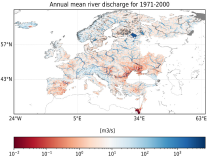
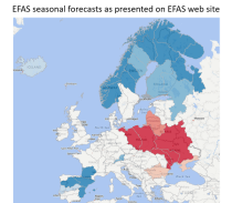
River discharge
Volumetric soil moisture
Snow water equivalent
Soil wetness index (root zone)
Runoff water equivalent (surface plus subsurface)
Interval/period: Wed, 10/14/2020 - Sun, 05/10/2026
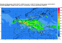
CAMS produces specific daily air quality analyses and forecasts for the European
domain at significantly higher spatial resolution (0.1 degrees, approx. 10km)
than is available from the global analyses and forecasts. The production is
based on an ensemble of eleven air quality forecasting systems across Europe. A
median ensemble is calculated from individual outputs, since ensemble products
Interval/period: Wed, 05/03/2023 - Fri, 05/08/2026
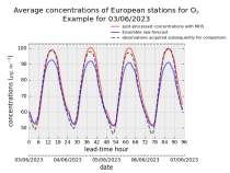
stations after optimisation using a statistical post-processing method called
Model Output Statistics (MOS). The unoptimised "raw" forecasts are also
provided in the same format.
The MOS method uses machine learning with predictive variables including
background air quality observation datasets, ECMWF meteorological forecasts and
the "raw" CAMS European air quality ensemble median forecast. The result is
Interval/period: Wed, 01/17/2024 - Fri, 05/08/2026
Interval/period: N/A

Interval/period: N/A

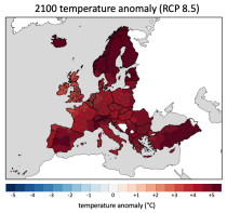
Interval/period: Sun, 01/01/1950 - Fri, 12/31/2100
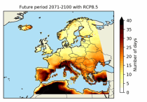
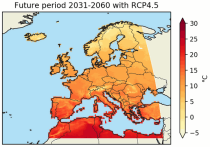
These heat wave and cold spell days are available for different future time periods and use different climate change scenarios.
Interval/period: Wed, 01/01/1986 - Mon, 12/31/2085

ECV datasets provide the empirical evidence needed to understand the current climate and predict future changes.
Interval/period: N/A
Interval/period: Tue, 12/01/2020 - Wed, 04/01/2026
Interval/period: Thu, 01/01/1976 - Fri, 12/31/2100
Interval/period: Thu, 01/01/1976 - Fri, 12/31/2100
River discharge
Volumetric soil moisture
Snow water equivalent
Soil wetness index (root zone)
Runoff water equivalent (surface plus subsurface)
Interval/period: Sun, 11/01/2020 - Wed, 04/01/2026
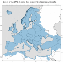
River discharge
Volumetric soil moisture
Snow water equivalent
Soil wetness index (root zone)
Runoff water equivalent (surface plus subsurface)
Interval/period: Fri, 01/01/1999 - Sun, 05/10/2026
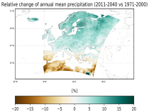
ECV datasets provide the empirical evidence needed to understand the current climate and predict future changes.
CIIs contain condensed climate information which facilitate relatively quick and efficient subsequent analysis. Therefore, CIIs make climate information accessible to application focussed users within a sector.
Interval/period: N/A
Interval/period: Wed, 01/01/1986 - Mon, 12/31/2085