Datasets

Interval/period: Mon, 01/01/1940 - Fri, 12/31/2100

Interval/period: N/A
Interval/period: Thu, 10/18/2018 - Wed, 07/31/2019

Interval/period: Sun, 01/01/1950 - Fri, 12/31/2100
Interval/period: Sun, 01/01/1950 - Sat, 05/09/2026
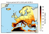
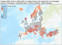
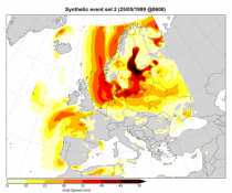
These heat wave and cold spell days are available for different future time periods and use different climate change scenarios.
Interval/period: Wed, 01/01/1986 - Mon, 12/31/2085
Interval/period: Mon, 01/01/2018 - Tue, 12/31/2024

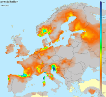
ECV datasets provide the empirical evidence needed to understand the current climate and predict future changes.
Interval/period: N/A
Interval/period: Sun, 01/01/1950 - Fri, 01/01/2100
Interval/period: Tue, 12/01/2020 - Wed, 04/01/2026
Interval/period: Fri, 01/01/2021 - Sat, 05/09/2026
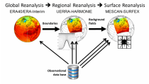
Spatial interpolation methods are applied to observational datasets to create gridded datasets.
In general, there are three types of such methods: deterministic (type 1), stochastic (type 2) and pure mathematical (type 3).
Interval/period: Sun, 01/01/1961 - Thu, 09/18/2025
Interval/period: Thu, 01/01/1976 - Fri, 12/31/2100
Interval/period: Thu, 01/01/1976 - Fri, 12/31/2100
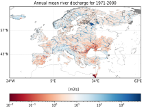
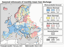
River discharge
Volumetric soil moisture
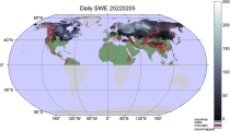
Snow water equivalent
Soil wetness index (root zone)
Runoff water equivalent (surface plus subsurface)
Interval/period: Sun, 11/01/2020 - Wed, 04/01/2026
River discharge
Volumetric soil moisture
Snow water equivalent
Soil wetness index (root zone)
Runoff water equivalent (surface plus subsurface)
Interval/period: Fri, 01/01/1999 - Sat, 05/09/2026
Interval/period: Tue, 01/02/1979 - Sat, 05/09/2026
Interval/period: Wed, 01/01/1986 - Wed, 11/30/2011
ECV datasets provide the empirical evidence needed to understand the current climate and predict future changes.
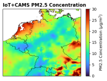
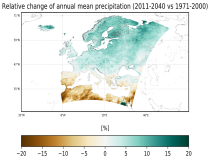
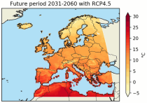
CIIs contain condensed climate information which facilitate relatively quick and efficient subsequent analysis. Therefore, CIIs make climate information accessible to application focussed users within a sector.
Interval/period: N/A
Interval/period: Wed, 01/01/1986 - Mon, 12/31/2085