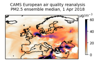
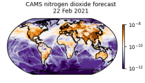
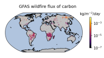
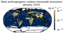
Datasets
Interval/period: Tue, 01/01/2013 - Tue, 12/31/2024
Interval/period: Thu, 01/01/2015 - Thu, 05/07/2026
Interval/period: Wed, 01/01/2003 - Wed, 12/03/2025
Interval/period: Sat, 01/01/2000 - Thu, 12/31/2020
Interval/period: Fri, 03/01/2024 - Thu, 05/07/2026
Interval/period: Wed, 01/01/2003 - Thu, 12/31/2020
Interval/period: Wed, 01/01/2003 - Thu, 12/31/2020
Interval/period: Mon, 01/01/1979 - Tue, 12/31/2024
Interval/period: Wed, 01/01/2003 - Sun, 12/31/2017
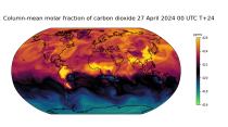
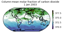
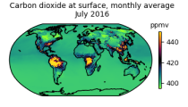
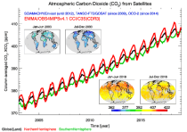
carbon dioxide
methane
tropospheric ozone
stratospheric ozone
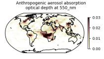
interactions between anthropogenic aerosols and radiation
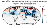
interactions between anthropogenic aerosols and clouds
Interval/period: Wed, 01/01/2003 - Sun, 12/31/2017
Interval/period: Wed, 01/01/2003 - Thu, 10/31/2024
Interval/period: Wed, 01/01/2003 - Sun, 12/31/2023
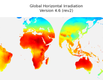
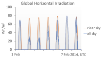
irradiation, as well as direct normal irradiation, on a latitude/longitude grid
covering land surfaces and coastal areas of Europe, Africa, Oceania, Eastern
South America, the Middle East and South-East Asia. It is created from 15 minute
resolved timeseries at each grid point. These timeseries were calculated by the
CAMS Solar Radiation Time Series Service and use information on aerosol, ozone
Interval/period: Sat, 01/01/2005 - Sun, 12/31/2023
Interval/period: Thu, 01/01/2004 - Thu, 05/07/2026
Interval/period: Tue, 10/01/2002 - Tue, 12/31/2024
Interval/period: Sat, 09/01/1984 - Sat, 01/31/2026
Interval/period: Sat, 09/01/1984 - Sat, 01/31/2026
Interval/period: Sat, 09/01/1984 - Sat, 01/31/2026
Interval/period: Sat, 09/01/1984 - Sat, 01/31/2026

Interval/period: Sat, 09/01/1984 - Thu, 07/31/2025
Interval/period: Mon, 01/01/1979 - Sun, 03/01/2026
Interval/period: N/A

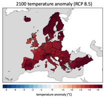
Interval/period: Sun, 01/01/1950 - Wed, 12/01/2100

Interval/period: N/A

Interval/period: Mon, 01/01/1940 - Fri, 12/31/2100