Datasets
Data is available from 1940 onwards.
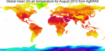
ERA5 replaces the ERA-Interim reanalysis.
Interval/period: Mon, 01/01/1940 - Thu, 06/25/2026
Data is available from 1940 onwards.
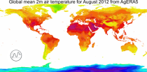
ERA5 replaces the ERA-Interim reanalysis.
Interval/period: Mon, 01/01/1940 - Thu, 06/25/2026
Data is available from 1940 onwards.
ERA5 replaces the ERA-Interim reanalysis.
Interval/period: Mon, 01/01/1940 - Fri, 05/01/2026
Data is available from 1940 onwards.
ERA5 replaces the ERA-Interim reanalysis.
Interval/period: Mon, 01/01/1940 - Fri, 05/01/2026

Data is available from 1940 onwards.
ERA5 replaces the ERA-Interim reanalysis.
Interval/period: Mon, 01/01/1940 - Thu, 06/25/2026

Data is available from 1940 onwards.
ERA5 replaces the ERA-Interim reanalysis.
Interval/period: Mon, 01/01/1940 - Thu, 06/25/2026

Interval/period: Sun, 01/01/1950 - Thu, 06/25/2026

Interval/period: Sun, 01/01/1950 - Fri, 05/01/2026

Interval/period: Sun, 01/01/1950 - Thu, 06/25/2026
Interval/period: Mon, 01/01/1979 - Sun, 03/01/2026
Interval/period: Tue, 12/01/2020 - Mon, 06/01/2026
Interval/period: Thu, 01/01/1998 - Fri, 12/31/2010
Interval/period: Sun, 01/01/1950 - Wed, 04/01/2026
Interval/period: Mon, 01/01/1979 - Tue, 06/23/2026
Interval/period: Mon, 01/01/1979 - Sun, 01/04/2026

Interval/period: Wed, 11/01/1978 - Sat, 06/20/2026

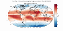
Interval/period: Sun, 01/01/2017 - Mon, 06/01/2026

Interval/period: Sun, 01/01/2017 - Mon, 06/01/2026

Interval/period: Thu, 01/01/1981 - Mon, 06/01/2026
Interval/period: Fri, 01/01/1993 - Mon, 06/01/2026

Interval/period: Thu, 01/01/1981 - Mon, 06/01/2026

Interval/period: Thu, 01/01/1981 - Mon, 06/01/2026

Interval/period: Thu, 01/01/1981 - Mon, 06/01/2026

Interval/period: Tue, 10/01/2002 - Sun, 04/12/2026

Interval/period: Fri, 01/01/1993 - Fri, 01/16/2026