The Copernicus Climate Change Service (C3S) seasonal forecast service is based on data from several state-of-the-art seasonal prediction systems.

calendar_today Interval/period: N/A

The Global Climate Observing System (GCOS) Reference Upper-Air Network (GRUAN) is an international reference observing network, established in 2006, of sites measuring essential climate variables above Earth's surface, designed to fill an important gap in the current global observing system. GRUAN measurements are providing high-quality climate data records from the surface, through the troposphere, and into the stratosphere.

calendar_today Interval/period: Sun, 01/01/1978 - Wed, 10/17/2018

This dataset provides access to two types of ozone observations: total column ozone estimates and vertical profiles of ozone concentration.
The total ozone estimates are based on solar UV radiation measurements made by ground-based spectrophotometers (Dobson or Brewer type spectrophotometers).
The vertical profiles of ozone concentration are estimated primarily using ozonesonde observations.
Data are available for 159 Dobson stations, 109 Brewer stations and 135 ozonesondes stations.

calendar_today 
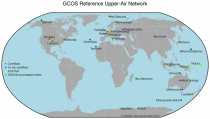
Interval/period: Tue, 01/01/1924 - Fri, 05/08/2026

This dataset provides estimates of water vapour derived from atmospheric delays in Global Navigation Satellite System
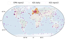
(GNSS) radio signals.
The initial data is collected from two in situ ground-based network of GNSS receivers – the International GNSS Service
(IGS) and EUREF Permanent Network (EPN). The IGS collects, archives, and freely distributes GNSS data from a
cooperatively operated global network of more than 500 ground-based GNSS stations since 1994. The EPN is a European

calendar_today Interval/period: Mon, 01/01/1996 - Fri, 05/08/2026

This dataset provides daily mid-morning measurements for Lake Surface Water Temperature (LSWT) derived from satellite observations. LSWT, together with five other variables (lake ice cover and thickness, water leaving reflectance, water level and extent) is recognised as the Essential Climate Variable (ECV) "Lakes" by the Global Climate Observing System (GCOS). LSWT is a key parameter in determining lake ecological conditions as it influences physical, chemical and biological processes.

calendar_today Interval/period: Thu, 06/01/1995 - Fri, 05/08/2026

This dataset provides lake water levels for 311 selected lakes on four continents derived from satellite radar altimetry.

calendar_today Interval/period: Wed, 01/01/1992 - Fri, 05/08/2026

This dataset provides global maps describing the land surface into 22 classes, which have been defined using the United Nations Food and Agriculture Organization’s (UN FAO) Land Cover Classification System (LCCS). In addition to the land cover (LC) maps, four quality flags are produced to document the reliability of the classification and change detection.

calendar_today Interval/period: Wed, 01/01/1992 - Sat, 01/01/2022

This dataset contains monthly daytime and nighttime clear-sky land surface temperatures (LSTs) and their uncertainty estimates from multiple Infra-Red (IR) instruments on polar orbiting satellites. Daytime and nighttime temperatures correspond to 10:00 and 22:00 local solar time (local solar time is defined as the time in a 24 hour day with 12 noon occurring when the sun is at its highest point at that longitude).

calendar_today Interval/period: Thu, 06/01/1995 - Tue, 12/31/2024

This catalogue entry provides access to a continuous series of near-surface climate observations collected in-situ at
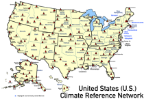
United States Climate Reference Network (USCRN) stations.
There are over 130 USCRN stations over the conterminous United States (U.S.), Alaska, and Hawaii.
The USCRN stations are managed and maintained by the U.S. National Oceanic and Atmospheric Administration (NOAA).
The USCRN observations include air temperature, humidity, wind speed, precipitation, solar radiation,

calendar_today Interval/period: Sun, 01/01/2006 - Fri, 05/08/2026

This catalogue entry provides access to vertical profiles of standard meteorological variables. It includes two archives.
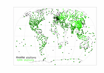
The first is version 2 of the Integrated Global Radiosounding Archive (IGRA) from 1978 which incorporates global
radiosounding profiles of temperature, humidity and wind from a large number of data sources,
which is 30% larger than the previous version 1. IGRA v2 is the result of quality assurance procedures applied to the

calendar_today Interval/period: Sun, 01/01/1978 - Fri, 05/08/2026

Single prediction that uses

observations prior information about the Earth-system ECMWF's highest-resolution model

HRES Direct model output Products offers "High Frequency products"  

4 forecast runs per day (00/06/12/18) (see dissemination schedule for details) Hourly steps to step 90 for all four runs.

Not all post-processed Products are available at 06/18 runs or in hourly steps.

calendar_today Interval/period: N/A

The sub-seasonal products comprise ensembles of individual forecasts up to 46 days and post-processed products of average conditions (e.g. weekly averages) and the associated uncertainty.

The purchase of the "Basic Set" +72, +96, +120, +144, +168 hrs is a mandatory prerequisite for the purchase of time steps in the range 12 to 66 hours.

The following sub-sets are available from the sub-seasonal forecast (46 days):

calendar_today Interval/period: N/A

This catalogue entry provides satellite-derived estimates of two related variables: Leaf Area Index (LAI) and fraction of Absorbed Photosynthetically Active Radiation (fAPAR). LAI and fAPAR are both Essential Climate Variables (ECVs) as defined by the Global Climate Observing System (GCOS), meaning they have been designated as essential for contributing to a comprehensive view of Earth’s climate, its variability and trends.

calendar_today Interval/period: Tue, 09/01/1981 - Sun, 12/01/2024

The dataset contains model projections of changes in marine physics and biogeochemistry and the lower trophic levels of the marine food web across the Northwest European Shelf and Mediterranean Sea out to the year 2100.

calendar_today Interval/period: Mon, 01/01/1979 - Mon, 12/31/2018

This dataset provides monthly means of mass-consistent, vertically integrated, atmospheric energy and moisture budget quantities derived from 1-hourly ERA5 reanalysis data.
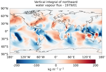
The vertically integrated budget diagnostics include the tendencies and lateral fluxes of total energy, water vapour, and latent heat (with the latent heat of vaporization varying with temperature). In addition, the divergences of the lateral fluxes are provided.

calendar_today Interval/period: Mon, 01/01/1979 - Fri, 05/08/2026

This dataset provides daily gridded data of sea ice concentration for both hemispheres derived from satellite passive microwave brightness temperatures. Sea ice is an important component of our climate system and a sensitive indicator of climate change. Its presence or its retreat has a strong impact on air-sea interactions, the Earth’s energy budget as well as marine ecosystems. It is recognised by the Global Climate Observing System as an Essential Climate Variable.

calendar_today Interval/period: Sun, 10/01/1978 - Mon, 09/29/2025

This dataset provides daily gridded fields of sea ice drift vectors for both hemispheres derived from satellite passive microwave brightness temperatures and atmospheric reanalysis data. Sea ice is an important component of our climate system and a sensitive indicator of climate change. Its presence or retreat significantly affects ocean-atmosphere interactions, the Earth’s energy budget as well as marine ecosystems. It is classified as an Essential Climate Variable by the Global Climate Observing System.

calendar_today Interval/period: Tue, 01/01/1991 - Thu, 12/31/2020

This dataset provides daily gridded data of sea ice edge and sea ice type derived from brightness temperatures measured by satellite passive microwave radiometers. Sea ice is an important component of our climate system and a sensitive indicator of climate change. Its presence or its retreat has a strong impact on air-sea interactions, the Earth’s energy budget as well as marine ecosystems. It is recognized by the Global Climate Observing System as an Essential Climate Variable. Sea ice edge and type are some of the parameters used to characterise sea ice.

calendar_today Interval/period: Wed, 10/25/1978 - Wed, 09/24/2025

This dataset provides daily and monthly sea ice surface temperature (IST) fields over the polar oceans from 1982 to the present. The data are derived from thermal infrared measurements from a single satellite sensor type: the Advanced Very High Resolution Radiometer (AVHRR) onboard National Oceanic and Atmospheric Administration (NOAA) and Meteorological Operational (MetOp) satellites.

calendar_today Interval/period: Mon, 01/01/1979 - Tue, 09/30/2025

This dataset provides gridded sea ice thickness data for the Arctic, derived from satellite observations. Sea ice plays a vital role in the climate system, influencing air-sea interactions, the Earth’s energy balance, and marine ecosystems. It is recognised by the Global Climate Observing System (GCOS) as an Essential Climate Variable (ECV). Sea ice thickness is a key characteristic used alongside other parameters such as concentration, edge, and type, all available in the Climate Data Store (CDS).

calendar_today Interval/period: Tue, 10/01/2002 - Sat, 04/12/2025

This dataset provides gridded daily and monthly mean global estimates of sea level anomaly based on satellite altimetry measurements. The rise in global mean sea level in recent decades has been one of the most important and well-known consequences of climate warming, putting a large fraction of the world population and economic infrastructure at greater risk of flooding. However, changes in the global average sea level mask regional variations that can be one order of magnitude larger.

calendar_today Interval/period: Fri, 01/01/1993 - Sun, 12/31/2023

This dataset provides global daily sea surface temperature (SST) data from the Group for High Resolution Sea Surface Temperature (GHRSST) multi-product ensemble (GMPE) produced by the European Space Agency SST Climate Change Initiative (ESA SST CCI). The GMPE system was designed to allow users to compare the outputs from different SST analysis systems and understand their similarities and differences. Although originally intended for comparison of near real time data, it has also been used to compare long historical datasets.

calendar_today Interval/period: Tue, 09/01/1981 - Sat, 12/31/2016

These seasonal data comprises ensembles of individual forecasts coupled to an ocean model and post-processed products of average conditions (e.g. monthly averages) with the associated uncertainty. Products are available for forecast month 8-13, each quarter (February, May, August, November).

The following sub-sets are available:

calendar_today Interval/period: N/A

The Essential Climate Variables for assessment of climate variability from 1979 to present dataset contains a selection of climatologies, monthly anomalies and monthly mean fields of Essential Climate Variables (ECVs) suitable for monitoring and assessment of climate variability and change. Selection criteria are based on accuracy and temporal consistency on monthly to decadal time scales.

calendar_today Interval/period: Mon, 01/01/1979 - Wed, 04/01/2026

This dataset contains 4 Essential Climate Variables (ECV) for the 18 bias adjusted Global Climate Models (GCM) from CMIP5: daily precipitation rate, and daily mean, maximum and minimum temperatures.
The data are bias adjusted using the Distribution Based Scaling (DBS) method versus the global reference dataset HydroGFD2.0, both bias adjustment method and global reference dataset developed by the Swedish Meteorological and Hydrological Institute (SMHI).
The DBS method is a parametric quantile-mapping variant.

calendar_today Interval/period: Thu, 10/12/2000 - Thu, 10/18/2018