
ECMWF produces not just medium-range weather forecasts but also extended-range ones up to six weeks ahead, and seasonal forecasts up to seven months ahead. The latter contribute to multi-centre predictions provided by the EU’s Copernicus Climate Change Service (C3S) run by ECMWF.
What can these forecasts tell us about the weather in the weeks and months ahead?
The first thing to note is that these are all ensemble forecasts, in other words they predict a range of possible conditions. This is then compared to the range of conditions typically seen in the past.
The predictions are also averaged over periods ranging from a week for extended-range forecasts to one to three months for seasonal forecasts. Shorter fluctuations in European winter weather are not considered because they are unpredictable at these timescales.
Forecasts of this kind can be made because of long-term drivers of the weather. These include La Niña or El Niño conditions in the equatorial Pacific Ocean and the Madden–Julian Oscillation (MJO) in the tropics. In recent years, the climate change signal has also been acting as a predictability driver at seasonal timescales.
Such forecasts have different skill for different regions of the world. Europe is a region where the skill of seasonal predictions is relatively low, as shown here for ECMWF’s November forecasts of winter precipitation. The predictability of weather trends in this region varies from year to year, and it is low on average. “In the northern hemisphere winter, Europe and much of northern Asia are some of the least predictable parts of the world,” ECMWF scientist Tim Stockdale says.
The 2022/23 winter in Europe
Let’s now look at a multi-centre prediction of 2-metre temperature for December–January–February 2022/23 that was issued in November, as reported by C3S.
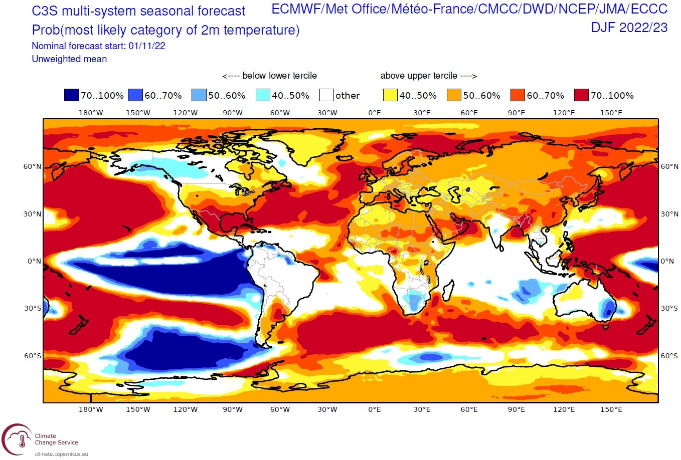
C3S multi-system seasonal forecast of 2-metre temperature from November 2022 for December–January–February 2022/23, combining the predictions from ECMWF, the UK Met Office, Météo-France, the Euro-Mediterranean Center on Climate Change (CMCC), the German National Meteorological Service (DWD), the US National Centers for Environmental Prediction (NCEP), the Japan Meteorological Agency (JMA), and Environment and Climate Change Canada (ECCC).
The chart describes, as an average over a number of forecast systems, where the ensemble members of each forecast tend to fall relative to their own climatology: shades of yellow to red denote areas in which ensemble members are predominantly in the upper third of the climatology (relatively warm), while shades of light to dark blue indicate areas in which they are in the lower third of the climatology (relatively cold).
The remaining areas, in other words areas where there is no predominance of ensemble members in the lower or upper third of the climatology, are left white. This could mean either that the ensemble members fall roughly equally across the different categories of temperature, or that they are concentrated in the middle category of near-normal temperatures – there are separate charts of the probabilities of each category which can be consulted to check this possibility.
The average of the probabilities from different systems is shown, so that high probabilities are only possible if there is good agreement between the different systems. Since each forecast ensemble is referenced to its own climatology, any systematic biases in the forecasts are removed before the different systems are combined.
The forecast favours cold conditions over the tropical Pacific due to La Niña, but apart from this, yellow and red colours predominate. This is a sign of a warming world, as the climatology is based on a past period (1993–2016).
Focusing on Europe, a relatively weak signal of warmer conditions compared to the climatology is seen, with about 40–60% of the ensemble members in the upper tercile category, instead of 33% expected from the climatological forecast. Although significant, it is worth remembering that 60–40% of the ensemble members are below the upper tercile.
If we look at the same forecast from just ECMWF, a broadly similar picture can be seen:
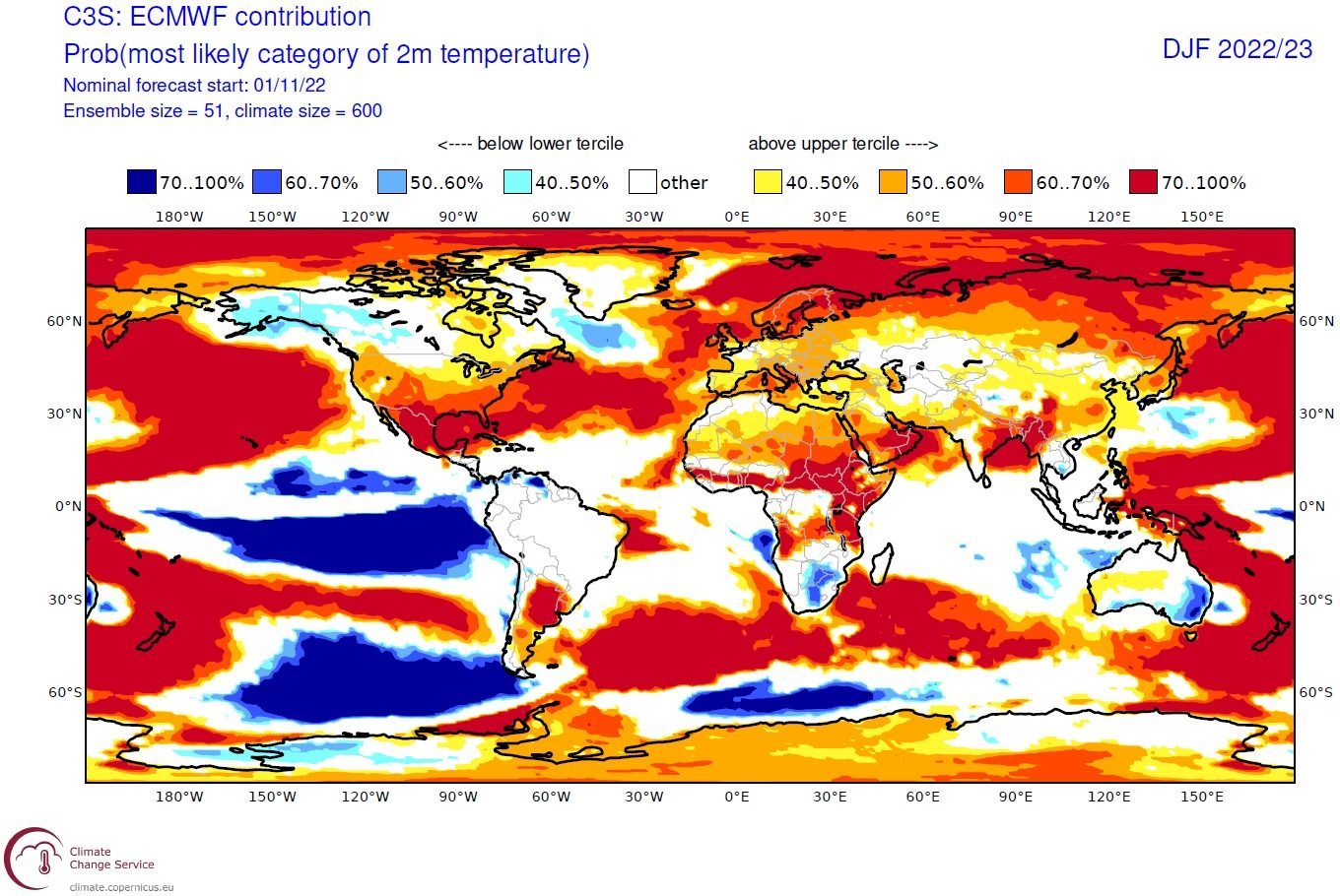
ECMWF’s seasonal forecast of 2-metre temperature from November 2022 for December–January–February 2022/23.
For some of Europe, however, the percentage of ensemble members that are in the upper tercile of the climatology is somewhat lower (notably in the Iberian Peninsula) or somewhat higher (notably in Scandinavia). “It is advisable to look at the forecasts from the individual centres contributing to C3S, side-by-side, to get a sense of the spread of possibilities,” says C3S seasonal prediction expert Anca Brookshaw.
"It is also important to remember that none of the models is perfect, and that the probabilities they estimate are not always reliable,” Tim Stockdale says. The reliability of probability forecasts can be estimated by looking at past performance, but this can be harder than it seems – the number of past cases is too small, forecast systems might perform much better in some situations than others, ensemble sizes are not always large enough, and the Earth’s climate is changing.
There are many ways in which forecasts might be calibrated to take account of both past system performance and known forcing factors such as the state of the tropical oceans and the stratosphere. This is why all the model output from C3S is made publicly available, so that other groups can work with the data in their own preferred ways.
C3S provides a wide range of forecasts for different parameters on its seasonal prediction page. New forecasts are issued every month. These include mean sea-level pressure forecasts, which can give an indication of expected atmospheric circulation. For European winter, the strength and direction of winds strongly modulate temperature and precipitation anomalies, thus significantly influencing both energy consumption and generation potential.
The C3S charts also include forecasts of the likelihood of La Niña or El Niño conditions. This is done by presenting predicted sea-surface temperature anomalies in different regions of the equatorial Pacific Ocean. These anomalies can have lasting effects on atmospheric circulation around the world.
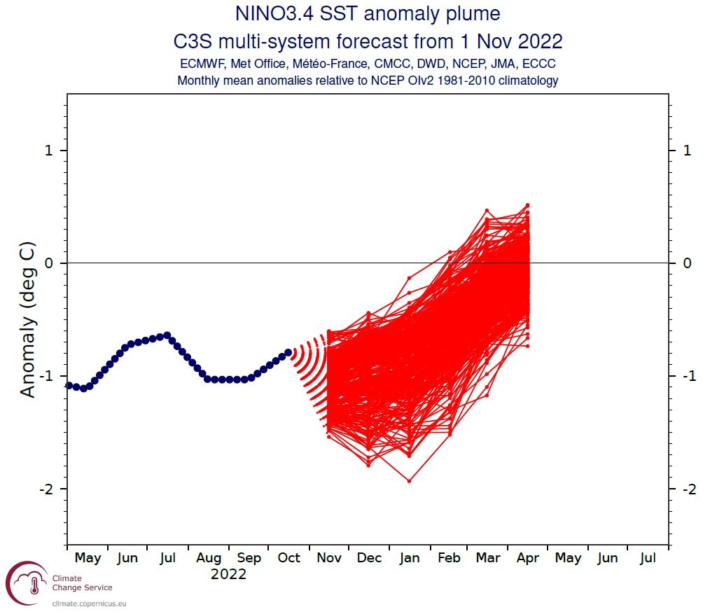
Multi-model forecast of SST anomalies, from ECMWF, the UK Met Office, Météo-France, CMCC, DWD, NCEP, JMA and ECCC, in the NINO3.4 region from 1 November 2022.
In the figure above, the ensemble forecasts from the different models agree that La Niña conditions will continue through the winter, probably moving back towards normal by the time we get to April. There is substantial disagreement on the size of the anomalies, though.
The ECMWF forecast, by contrast, has a relatively narrow range of predicted values and may not capture the full range of uncertainty in the forecast.
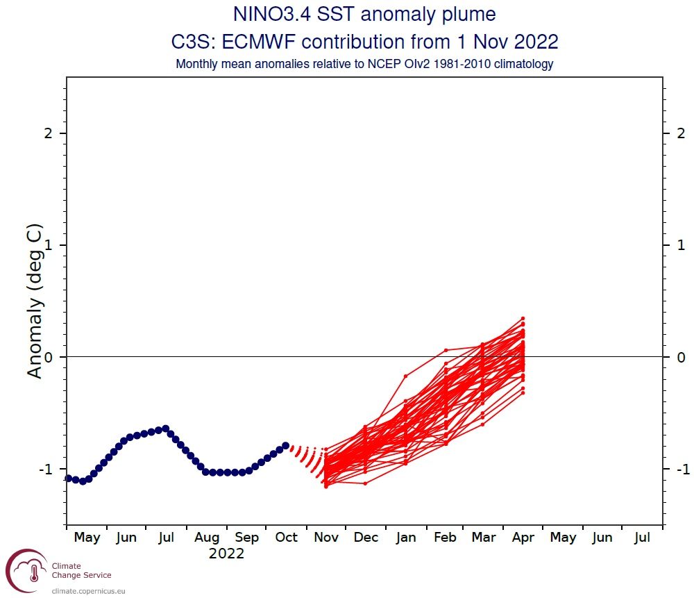
ECMWF forecast of SST anomalies in the NINO3.4 region from 1 November 2022.
The role of extended-range forecasts
Extended-range forecasts, up to 46 days ahead, provide information between seasonal forecasts on the one hand and medium- or short-range forecasts on the other. They can recognise the effects of events that become predictable at shorter-than-seasonal time frames, such the MJO or changes in the stratospheric polar vortex.
The chart below shows the weekly mean 2-metre temperature anomaly derived from a week-three ECMWF ensemble forecast starting on 7 November 2022.
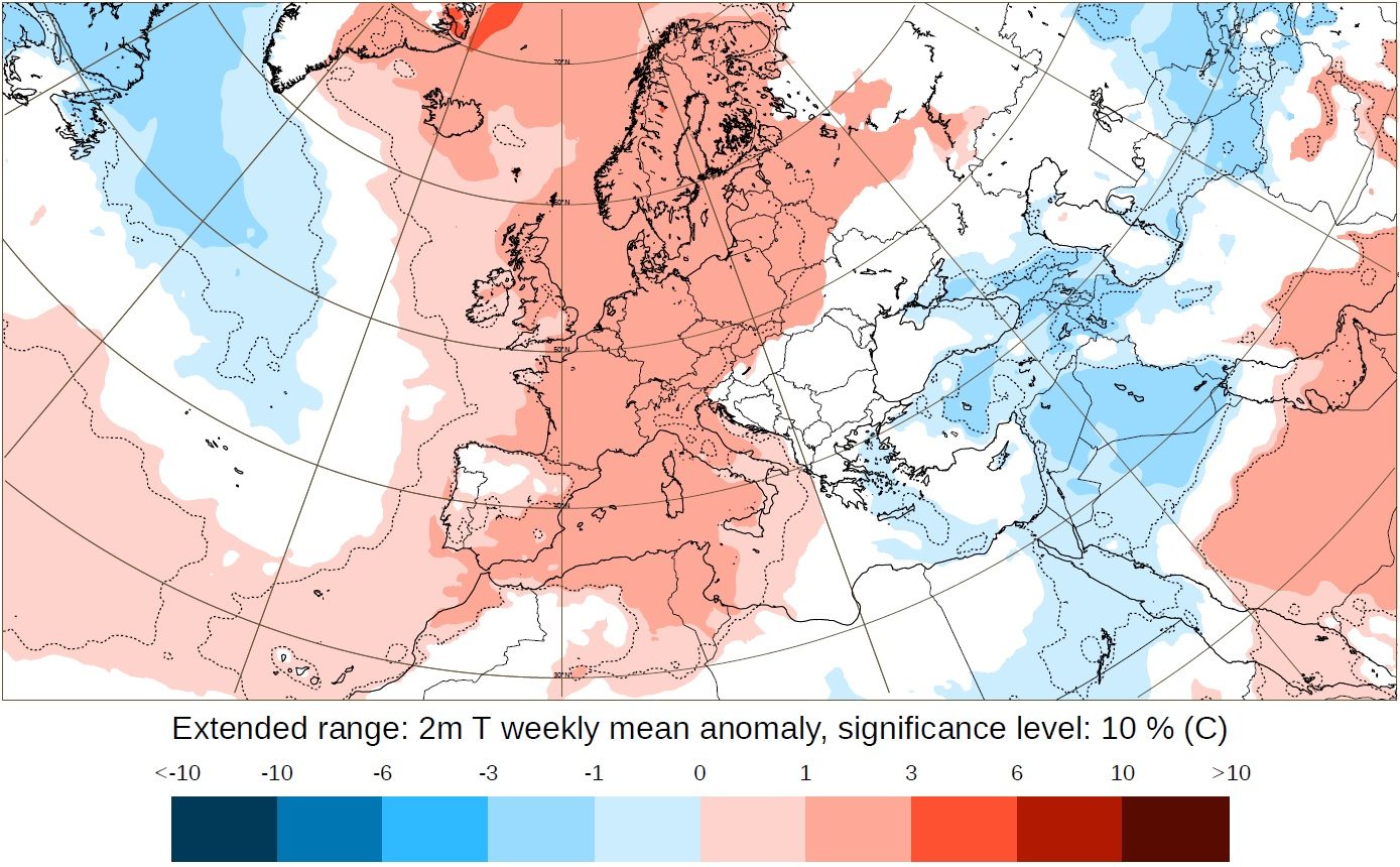
ECMWF extended-range forecast of the 2-metre temperature weekly mean anomaly for 21 to 28 November 2022, from 7 November 2022. Blank areas show where the ensemble forecast is not significantly different from the model climatology at a 10% significance level. The 1% significance level is indicated by the dotted grey contours.
It should be noted that the chart above just presents the mean anomaly of a whole ensemble of forecasts. This is not a prediction of what will happen but rather shows the size of the shift in the centre of the distribution of possible outcomes.
The next chart shows the probability that ensemble members are in the upper tercile of the forecast distribution.
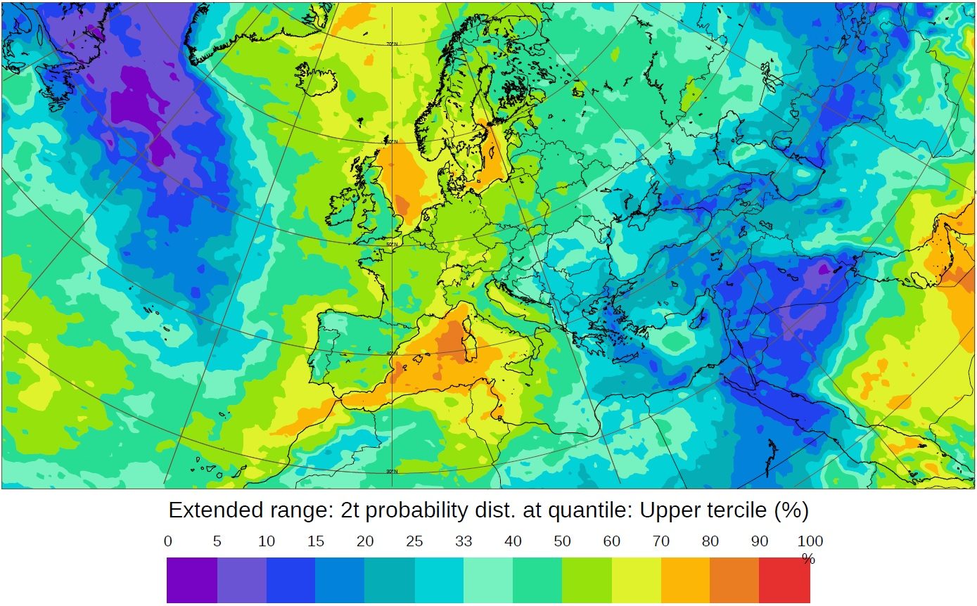
ECMWF extended-range forecast, for 21 to 28 November 2022 and starting from 7 November 2022, of the 2-metre temperature probability distribution in the upper tercile of the climatology.
“What we are trying to capture with the extended-range forecasts is variability within a season,” says ECMWF scientist Frédéric Vitart. “Extended-range forecasts can accurately anticipate more phenomena than seasonal forecasts, and they are issued for shorter timescales. They can thus be a useful bridge to medium- and short-range forecasts.”
Further resources
C3S multi-model seasonal forecasts can be accessed on the C3S website and ECMWF extended-range forecasts are accessible on the ECMWF website.