
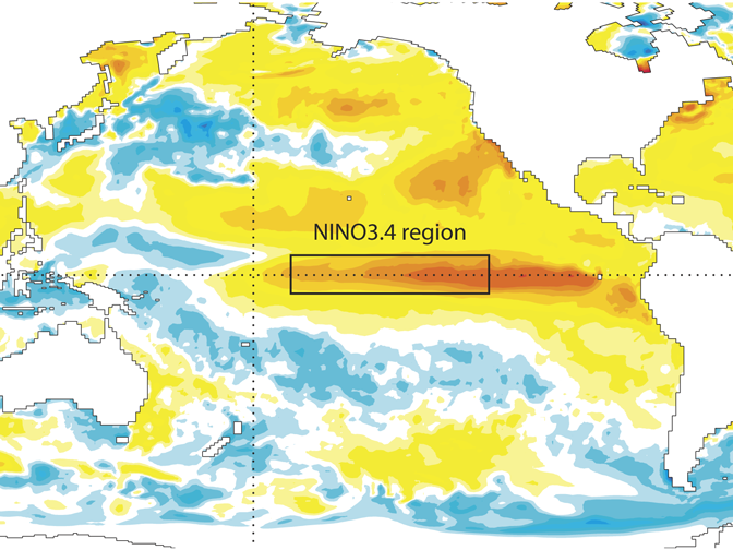
El Niño conditions in the central Pacific are now very strong, and sea-surface temperature anomalies are continuing to increase slowly as the event moves towards its expected peak at the end of the year.
An El Niño event is a prolonged period of abnormally high sea-surface temperatures (SST) in the tropical Pacific Ocean.
The story so far
Relative to the 1981–2010 average, the sea-surface temperature anomaly in the NINO3.4 region has increased further from the already very high August values, with the September anomaly exceeding 2.2 °C. This is in line with forecasts, and it is the warmest September value on record.
Looking at the absolute SST in NINO3.4, temperatures are now touching 29 °C and rising. The fact that the absolute SST is continuing to warm will enable the SST anomaly to continue to grow, even though the climatological average temperatures at this time of year are fairly stable. In the far eastern Pacific (NINO1+2), anomalies continue to be quite large, but they are much smaller than in the exceptionally strong 1997 El Niño event.
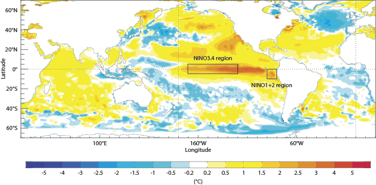
Average sea-surface temperature anomalies in September 2015. The chart shows sea-surface temperature anomalies compared to the 1981–2009 average.
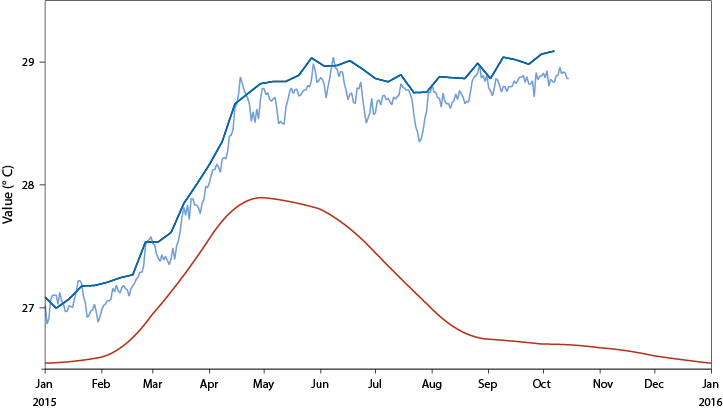
Average and observed sea-surface temperatures in NINO 3.4. The chart shows the average evolution of sea-surface temperatures in the NINO3.4 region based on the years 1981 to 2010 (red line) and the observed evolution since January 2015 according to two different analyses (dark and light blue lines). The difference between the red and blue lines is the sea-surface temperature anomaly.
Latest forecasts
The latest forecasts suggest that SST anomalies in the central Pacific may increase further and are expected to peak around December. As discussed in a previous update, the ECMWF model can overestimate anomalies in exceptional events, so the uppermost values in the plume plots may not be reliable.
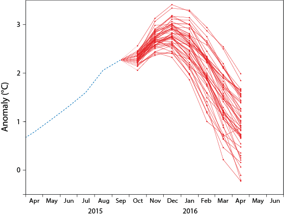
ECMWF plume of NINO3.4 sea-surface temperature anomalies. The chart shows an ensemble of predicted SST anomalies over the NINO3.4 region produced on 1 October from the ECMWF model. Ensemble forecasts account for the uncertainties inherent in the prediction of weather and ocean parameters by producing a set of possible outcomes.
There also remains uncertainty due to unpredictable variations in the winds over the Pacific. In this regard, early October has seen a very large westerly wind burst over the equatorial Pacific Ocean, which will act to drive SST higher in the coming weeks and months. This wind burst is partly included in the seasonal forecasts from 1 October, but the full intensity may not be represented, so the forecasts may slightly underrepresent the continued warming of SST.
On the other hand, the latest ECMWF extended-range forecasts suggest that a Madden–Julian oscillation (MJO) event may result in a temporary weakening of the wind anomalies in early November, which would have the opposite effect. The MJO is a travelling pattern of tropical rainfall. The seasonal forecasts do suggest that the amplitude of El Niño may decline fairly rapidly in the early part of 2016.
Forecasts for the NINO1+2 region suggest that anomalies are likely to remain large in the coming months, most likely in the range of 2–3 °C, but are expected to be below the exceptionally high values (exceeding 4 °C) seen in 1997. This El Niño event remains more central-Pacific-focussed than that of 1997, but it should be noted that there remains substantial spread in the forecasts, and NINO1+2 temperature anomalies are likely to remain very large by historical standards.
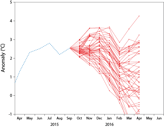
ECMWF plume of NINO1+2 sea-surface temperature anomalies. The chart shows the predicted sea-surface temperature anomalies over the NINO1+2 region produced on 1 October from the ECMWF model.