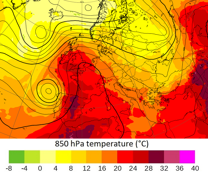

A heatwave is currently hitting much of Europe with different but very high intensity levels. National meteorological services of each of the affected countries are responsible for the dissemination of information and warnings. The statement below only aims to provide a general view of the current situation.
A slow-moving high-pressure area has been and is still transporting hot air from North Africa over western and parts of central Europe. The hot air is moving northwards, first affecting Portugal, Spain, France, now the UK, and imminently reaching the Benelux countries and western Germany, Switzerland, and northern Italy. It is expected that local/regional temperature records will be broken this week.
In combination with low precipitation rates over the last few weeks over most of these areas, this situation has been and is leading to a high risk of wildfire as currently observed on the Iberian Peninsula and France. The event is also associated with very high ozone levels.
The event was forecast at least three weeks in advance, but until last week, there was significant uncertainty about the extent and severity of the heatwave.

The image shows an 18-hour forecast of 500 hPa geopotential height (contours) and 850 hPa temperature from 00 UTC on 18 July 2022.
ECMWF forecasts are updated four times a day and the latest can be found on our open charts website.
Please observe national and regional warnings.
Further reading
- Copernicus scientists warn of very high ozone pollution as heatwave continues across Europe, Copernicus Atmosphere Monitoring Service (CAMS) press release, 19 July 2022
- Q&A - wildfires, Copernicus Atmosphere Monitoring Service (CAMS)
- Emerton, R., C. Brimicombe, L. Magnusson, C. Roberts, C. Di Napoli, H.L. Cloke & F. Pappenberger, 2022: Predicting the unprecedented: forecasting the June 2021 Pacific Northwest heatwave. Weather. https://doi.org/10.1002/wea.4257