In July 2020, ECMWF started assimilating European Mode-S winds. These are derived from aircraft Mode-S messages to air traffic control by the European Meteorological Aircraft Derived Data Center (EMADDC, part of the Royal Netherlands Meteorological Institute, KNMI). The EMADDC processing is documented by de Haan et al. (https://amt.copernicus.org/preprints/amt-2024-110/). Numbers of flights were severely depressed by the COVID-19 pandemic in summer 2020, but they have since recovered to near pre-pandemic levels. In summer 2022, it was discovered that ECMWF was assimilating too many Mode-S reports in central Europe, degrading the analysis. We stopped assimilating Mode-S for a year whilst a revised 'box-thinning' algorithm was tested. This was implemented and Mode-S usage reinstated in November 2023 (Ingleby, 2025, QJRMS, under review). Mode-S messages are available elsewhere, depending on the local air traffic control system, and this encouraged the setting up of the EMADDC Met Office Global Mode-S data stream: https://emaddc.com/participate/data+users/emaddc-met-office-global/default.aspx. ECMWF is now assimilating some of these global data to improve the starting conditions of its weather forecasts.
Global Mode-S winds at ECMWF
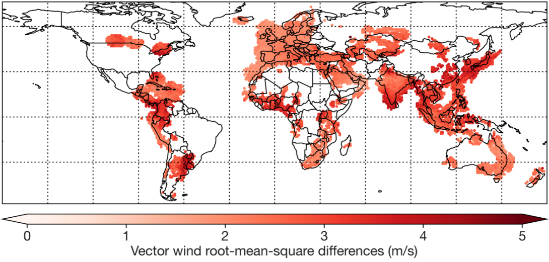
Global Mode-S Enhanced Surveillance (EHS) messages are procured by the UK Met Office from Flightradar24 and routed directly from Flightradar24 to EMADDC, where they are processed into derived meteorological observations. The data became available to ECMWF in mid-October 2024, and several trials were run from 15 October to 31 January 2025. The results were very encouraging, and the Global Mode-S winds have been assimilated operationally at ECMWF from 8 May 2025. The first figure shows the cruise level coverage in May 2025. In parts of eastern Europe and the Middle East, there are gaps due to GPS interference, and also occasional bad data that was not detected. Compared to European Mode-S, there are some additions, e.g. Iceland and parts of the Mediterranean, but the main benefits are elsewhere. The upper tropospheric root-mean-square (RMS) vector wind differences are particularly large in the tropics. It is thought that this is due to deep convection and to the relative lack of wind observations in the tropics.

The selection of used aircraft data
The 2025 change includes modifications to the aircraft thinning so that where available other aircraft data types, such as from the Aircraft Meteorological Data Relay (AMDAR) programme, are chosen ahead of Mode-S. Different box sizes were also tested, including longer horizontal scales in the upper troposphere, based on correlation results in Ingleby (2025). The configuration implemented operationally uses box sizes of 44 km in the lower troposphere, up to 500 hPa, increasing to 95 km at 200 hPa. The boxes are 20 hPa in the vertical and 30 minutes in time – only one aircraft report is assimilated in each box. Assimilation of Mode-S temperatures was retested, but the impact was small and mixed, so this was not implemented operationally. The largest impact of radiosonde temperatures is in the lower troposphere, and because they are not reported directly but must be rederived, Mode-S temperature errors are larger in the lower troposphere.
Results
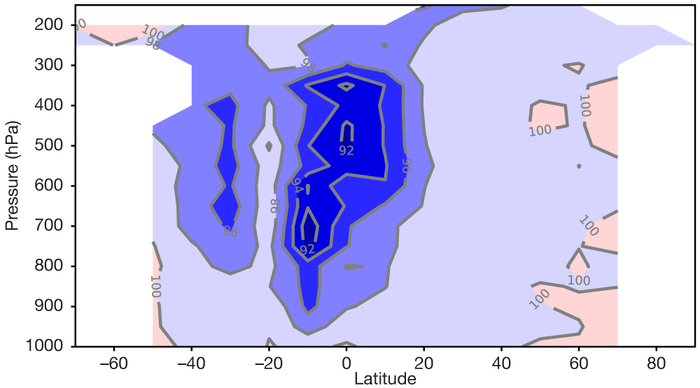
The second figure shows the effect of the change on 12-hour forecast fit to AMDAR aircraft winds – the effect measured against radiosondes and satellite data shows similar patterns. At short range, the largest improvement (up to about 8%) is in the tropical winds, with southern mid-latitudes also showing large improvement. In the medium range, there are significant improvements to mid-latitude forecasts measured against both observations and analyses. The impact over Europe is largely neutral, because Mode-S was already used there, but there is clear benefit over Asia. The number of used aircraft winds per day increased from 691K to 1,695K in the trial. This is a huge increase, and it gives a large benefit to short- and medium-range weather forecasts. The extra wind data in the tropics are especially welcome, and we thank our partners at the Met Office and KNMI for making these data available.
