During the spring of 2025, western Europe experienced strong contrasts in the weather. As seen in the precipitation anomalies from ECMWF's ERA5 reanalysis for 25 February to 1 June, Portugal, Spain, and the northern-central Mediterranean coasts were much wetter than normal, while large parts of north-western Europe were much drier than normal. For example, according to the UK Met Office, spring in the UK was the warmest and sunniest on record. The exception was the Norwegian mountains, which experienced a wet anomaly. More information about the hydrological conditions can be found in the Copernicus C3S Climate Bulletin (https://climate.copernicus.eu/precipitation-relative-humidity-and-soil-moisture-may-2025). Here, ECMWF's sub-seasonal and seasonal forecasts for western Europe in this year's spring will be discussed.
Sub-seasonal forecasts
To evaluate the predictability of mean anomalies over the three-month period, we use composites of ensemble mean, weekly anomaly forecasts issued on Mondays from the sub-seasonal forecasting system (see the first image). The reference climatology is the past 20 years, as used in the ECMWF re-forecast dataset. The period covered is 25 February to 1 June. For the week-2 composite (forecast day 7–14), the general precipitation pattern over western Europe was well captured, but with lower amplitude, as expected from an ensemble mean on this time range. However, in the composite of week-3 forecasts, the signal disappears. Instead, the forecasting system predicted a slightly wet anomaly over the period for Britain and Ireland, which experienced the strongest dry anomaly over Europe in ERA5. Looking further out (composite of week-6 forecasts), not many European anomalies were predicted. On the other hand, a clear wave pattern appears over the Atlantic, with a wet node over the Caribbean, a dry node over the western Atlantic and a wet node over the north-eastern Atlantic centred around Iceland.

To further understand the anomalies, the next image shows the corresponding anomalies for geopotential height at 500 hPa. In the seasonal mean, the spring was characterised by a strong positive anomaly over north-western Europe with a centre between Scotland and Iceland, and a trough located west of the Iberian peninsula. In line with the precipitation anomalies, the pattern for geopotential height at 500 hPa was somewhat captured in the week-2 forecasts, but it vanished in the week-3 forecasts. For week 6, a zonal positive anomaly was predicted in a diagonal from the southern US over the Atlantic to Europe, and a negative anomaly centred over Iceland. It probably resulted in the predicted wet anomaly centred around Iceland, which became a dry anomaly in the outcome.

Seasonal forecasts
The anomaly pattern of geopotential height at 500 hPa seen in week 6 was also present in the ensemble mean seasonal forecast valid for March–April–May from November (anomalies calculated with reference to the period 1993 to 2016). The anomaly seems to have been persisted from the previous season (December–January–February) in the same forecast (see the third image). It indicates that a similar forcing was present in the forecasts for the winter and spring. Further investigation is required to understand the origin of the incorrect pattern, present in both week-6 and seasonal forecasts.

Intra-seasonal variability
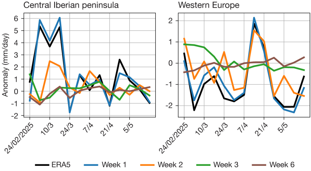
The intra-seasonal variability of the precipitation anomalies over the central Iberian Peninsula shows that especially March was particularly wet but with additional wet weeks later on (see the first plot of the fourth image). Even the week-2 forecast struggled with the onset of the wet March, and the wet period was totally missed in the week-3 forecasts. For the full 3-month (13-week) period, the correlation between week-2 forecasts and ERA5 was 0.28 and for week-3 forecasts –0.34. It shows that the sub-seasonal forecasts did not capture the intra-seasonal variability. For the box over western Europe, the week-2 forecast was better (correlation of 0.75), and it captured the break in the dry period in the second half of April, as well as the transition back to drier conditions afterwards (see the second plot of the fourth image). But again, the week-3 forecasts missed the intra-seasonal variability (correlation of 0.09).

Conclusion
While spring 2025 was exceptional in terms of the weather in western Europe, predictability on the sub-seasonal and seasonal scale seems to have been low. One could speculate that the anomalies were a result of a sequence of synoptic events which were not connected to a large-scale forcing on the seasonal scale. However, with the relatively strong and persistent pattern seen in the seasonal forecast, which did not verify, further investigations of the drivers of predictability for the past season are warranted.