Successful weather forecasts begin with accurate estimates of the current state of the Earth system. These estimates combine the latest observations with a short-range forecast constrained by previous observations through a process called data assimilation. At ECMWF, direct 'all-sky' assimilation of satellite radiances has become an essential part of forecasting by providing improved initial conditions in the presence of clouds and precipitation. Until recently, mainly microwave satellite observations have delivered detailed insights into cloud- and precipitation-affected regions. In previous Newsletters, we reported on initial efforts towards exploiting visible radiances (Benedetti et al., 2020; Steele et al., 2022). This article highlights ECMWF's advanced initiatives to leverage underutilised visible and near-infrared radiances, uncovering parts of the electromagnetic spectrum that have previously been inaccessible to numerical weather prediction (NWP). Progress was achieved by close collaboration with the German National Meteorological Service (DWD). DWD's Hans Ertel Centre for Weather Research (HErZ) pioneered the use of visible radiances in NWP in recent years. Researchers within HErZ developed advanced observation operators for visible radiances (Scheck, 2021; Baur et al., 2023), which are now distributed to the broader community through the NWP Satellite Application Facility (SAF) (EUMETSAT, 2025).
Preparing the ground
ECMWF has long led the way in utilising cloud-affected satellite observations. In 2009, ECMWF began assimilating humidity-, cloud-, and precipitation-sensitive microwave data for NWP (Geer & Bauer, 2011). Over the past decade, the use of microwave instruments has expanded a lot, substantially improving forecasts, especially in the medium range. Efforts are currently deployed to exploit information on cloud and precipitation in 'all-sky' conditions, using a broad range of available observations, including passive and active satellite instruments. Particularly relevant is the recently launched EarthCARE satellite with a lidar and Doppler radar, which will be assimilated and used to evaluate the model cloud and precipitation (Fielding et al., 2025). Recently, ECMWF has also started exploring visible radiance satellite observations for NWP, and this activity is now reaching pre-operational maturity.
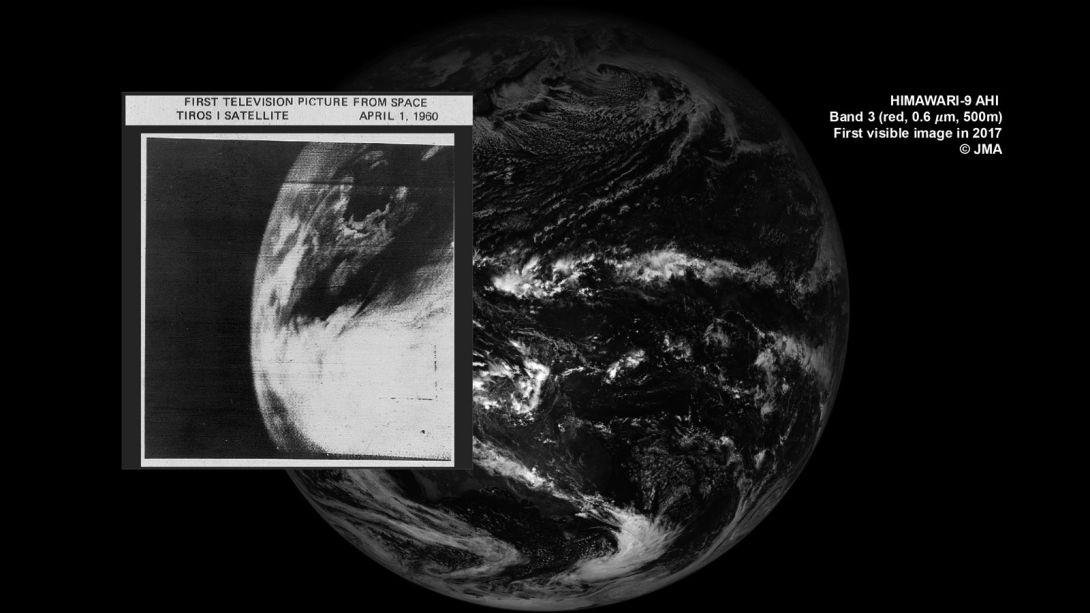
Visible observations possess unique properties compared to other observation types. They can offer highly detailed cloud information at much higher spatial and temporal resolutions than microwave sounder observations. Broadband visible observations are among the first satellite measurements taken from space (see Figure 1). Nowadays, geostationary satellite imagers provide unprecedented high-resolution data at both visible and infrared wavelengths. However, integrating visible radiances into weather models has historically faced substantial challenges, preventing their operational use in global NWP models until recently (see Box A).
A
Using visible radiances
Three major developments today enable the use of visible satellite observations in numerical weather prediction:
-
Higher model resolution and improved simulations of clouds, as data assimilation algorithms can only assimilate what models can simulate. These developments have been incorporated into successive model versions, which have been shown to have a growing degree of realism in the simulation of cloud features, including correct positioning.
-
Development of advanced linearised moist physics in tangent linear and adjoint models, allowing forecasts to be adjusted effectively by fitting models to cloudy observations. This has been one of the greatest achievements for the exploitation of cloud-affected observations within the four-dimensional variational data assimilation framework (4D-Var).
-
Continual efforts to improve the observation operator accuracy and speed for the simulation of visible and near-infrared satellite images (Scheck 2021; Baur et al., 2023). Until recently, the computational cost of radiative transfer calculations in this part of the electromagnetic spectrum was prohibitive for forecasting applications. Thanks to the development of fast codes, supported also by machine learning, these calculations can be achieved sufficiently fast.
Radiative transfer simulations of visible and near-infrared radiances noticeably differ from previously used observation types. Visible radiation originates directly from sunlight, and how it is reflected or scattered is highly sensitive to details of the optical properties of the atmospheric constituents, particularly cloud and aerosol particles. In the visible and near-infrared part of the spectrum, multiple-scattering processes dominate the radiative transfer, significantly increasing computational demands of 'observation operators' – radiative transfer models that translate model atmospheric profiles and surface properties into simulated radiances for comparison with the observed values.
ECMWF employs RTTOV (Radiative Transfer for TOVS; EUMETSAT, 2025), a fast radiative transfer model, as a forward model to simulate satellite radiances in the Integrated Forecasting System (IFS). RTTOV is developed within the European Organisation for the Exploitation of Meteorological Satellites (EUMETSAT) NWP SAF. RTTOV now also incorporates a fast visible wavelength radiative transfer model, called the Method for Fast Satellite Image Synthesis (MFASIS; Scheck 2021), enabling real-time monitoring and assimilation of visible and near-infrared radiances. This crucial development enables the operational use of visible observations in NWP today.
Insight from visible light: monitoring visible reflectances
The CLOud VISible (CLOVIS) projects funded by the European Space Agency (ESA) and the CERTAINTY project (https://certainty-aci.eu/) from the EU's Horizon programme have significantly advanced ECMWF's capabilities by enabling experimental monitoring and assimilation of visible reflectances from Ocean and Land Colour Instruments (OLCI) (see Necker et al., 2025).
The two OLCI instruments onboard ESA's low Earth orbit Sentinel-3A/B satellites provide nearly daily global observation coverage (see Figure 2). After observation preprocessing, they can deliver about half a million visible reflectance observations per channel daily. Many visible observations are 'window' channels, as they see the Earth's surface under cloud and aerosol-free conditions. This feature also emphasises the need for accurate surface reflectivity models for land and ocean surfaces. This is indicated, for example, by differences between the model and observations over the ice-covered poles (see Figure 2).
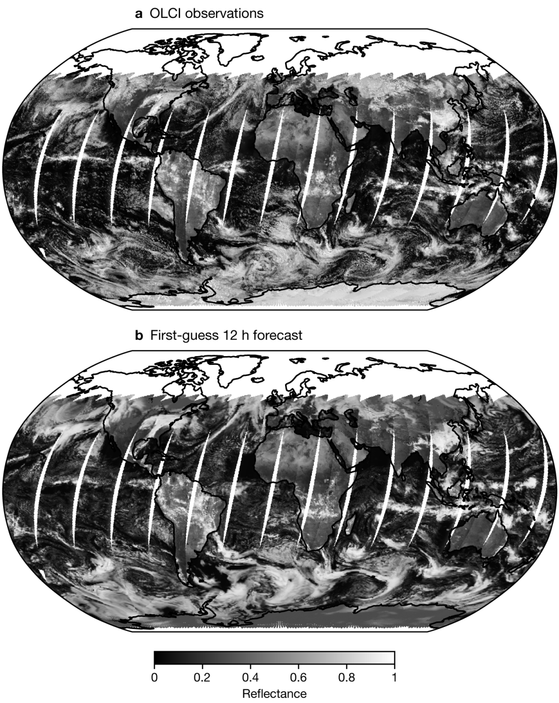
Monitoring observations against radiances simulated by state-of-the-art NWP models is crucial to ensuring the reliability of both satellite observations and model performance. The operational use of OLCI visible reflectances also requires reliable instrument monitoring to allow rapid responses in case of any instrument anomalies, and timely notifications for planned changes that could impact data quality. Initial near-real-time monitoring experiments with OLCI visible reflectance data at 665 nm have emphasised the need for careful data screening, especially for areas affected by ice, snow, or observations at extreme sun or satellite angles (see Figure 3). Early evaluations confirmed a known observation reflectance brightness bias of about 1% between the two OLCI instruments on Sentinel-3A and -3B. Systematic comparisons between model and observed data also made it possible to identify cloud biases in the model, for instance in maritime stratus clouds, predominantly near coastal areas in the Pacific and at high latitudes. Detected cloud biases showed a seasonal dependence. These results highlight that visible observations can inform model cloud physics developments. Opportunities involve statistical model evaluation, tuning of parametrizations that describe unresolved model processes, or the estimation of uncertain model parameters.
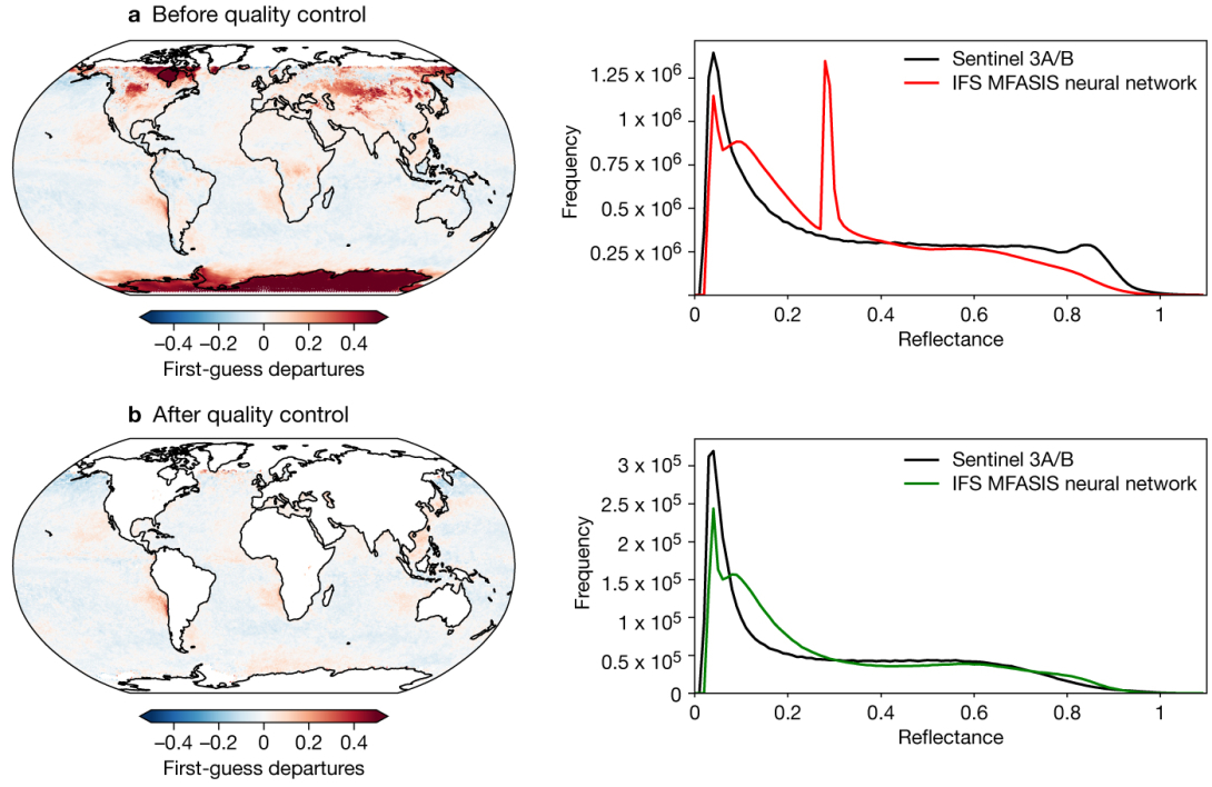
Comparing the climatology of observed and simulated reflectances before and after observation screening underlines the need to address systematic differences between the model and observations (see the histograms in Figure 3). For example, finding optimal cloud overlap schemes or handling heterogeneous land surfaces poses challenges for visible assimilation. Insufficient model performance in clear-sky conditions can harm assimilation efforts without proper observation screening. Exclusively using data over homogeneous ocean surfaces and removing areas affected by snow and ice effectively reduces systematic differences, therefore enhancing the possibilities for successful assimilation.
ECMWF is currently expanding the developments implemented for OLCI to visible reflectances observed by imagers on geostationary operational satellites, an initiative undertaken in collaboration with DWD. This collaboration will further progress towards assimilating geostationary visible reflectances for improved cloud analysis, marking a natural evolution of current capabilities. Establishing operational monitoring of visible satellite observations in the next round of IFS model improvements (Cycle 50r1, to be introduced this autumn) will represent a significant milestone, setting the stage for future operational assimilation of such observations.
In addition, ECMWF is preparing to exploit visible reflectances to improve the initialisation of aerosol forecasts provided by the EU's Copernicus Atmosphere Monitoring Service (CAMS), operated by ECMWF. This effort is supported by the CAMS EVolution project (CAMEO; https://www.cameo-project.eu/) from the EU's Horizon programme, and it involves the use of visible observations from which the effect of clouds is removed. These observations can be used to infer the amount of aerosol particles which are present in the atmosphere, using 4D-Var data assimilation. A bespoke new fast radiative transfer operator for aerosols is currently being developed by DWD and will be included in the next RTTOV release v14.1. The challenges are similar to those faced when using cloud information. However, the signal from the aerosols is often masked by more reflective clouds, and extra processing is required to be able to identify the aerosol contribution. Efforts are ongoing to exploit the newly developed operators within the IFS for this specific application.
First visible reflectance assimilation in the IFS
DWD has successfully demonstrated the benefits of using visible satellite data in its operational regional weather prediction model (ICON) – see Scheck et al., 2020. Building upon this, ECMWF's first experiments with assimilating OLCI 655 nm visible reflectances have also shown encouraging results on the global scale, significantly reducing cloud biases and enhancing the accuracy of model-simulated reflectances in cloudy regions (see Figure 4). These advances at DWD and ECMWF, working collaboratively, represent a significant advance, opening a previously unexplored part of the electromagnetic spectrum for global NWP.
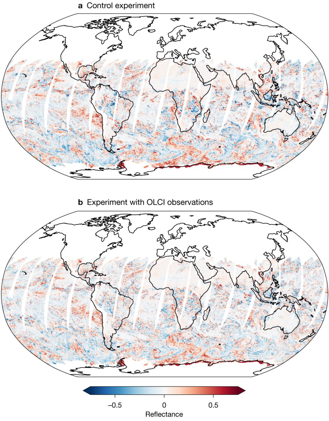
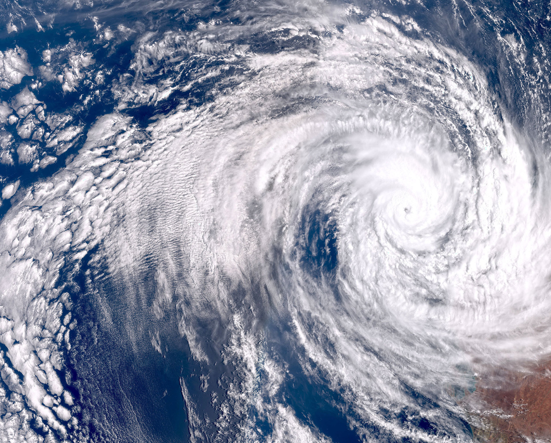
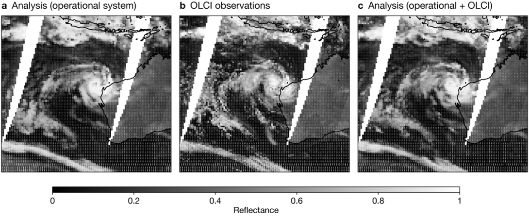
The impact of assimilating OLCI 655 nm visible data was assessed through Observing System Experiments (OSEs). Data from Sentinel-3A/B satellites were incorporated into a baseline experiment presenting either the full or a depleted observing system to evaluate improvements in analyses and forecasts. These experiments proved that the IFS 4D-Var system can successfully assimilate visible radiance data. Figures 5 and 6 illustrate the impact observed in the case of tropical cyclone Sean near Australia on 20 January 2025. Assimilating only a single visible channel on top of the full observing system led to adjusted cloud fields. This case study emphasises the potential for visible satellite observations to enhance forecasts of high-impact weather events, which heavily depend on accurate simulations of cloud structures. While initial assimilation trials are highly promising, ongoing research and development are just the beginning of an exciting endeavor. Future successful operational assimilation of visible observations will require demanding work and further improvements of forecast models, observation operators, and observation processing (see Box B).
B
Towards operational use of visible observations
ECMWF already provides operational real-time simulated images for top-of-the-atmosphere visible reflectance products on ecCharts (https://eccharts.ecmwf.int - restricted access) and OpenCharts (https://charts.ecmwf.int/). For NWP, visible observations from both polar-orbiting and geostationary satellites will offer more direct benefit through their use in data assimilation. Operational monitoring of visible reflectances is planned to become an operational standard with the upcoming model upgrade (IFS Cycle 50r1). However, before visible observations can be assimilated operationally, several improvements are required:
-
Advanced methods for variational quality control and bias correction must be put in place.
-
Improved models of observation errors must be developed and implemented.
-
Model and operator settings must be refined to mitigate systematic differences between the observation and the model.
-
Technical updates to the IFS are necessary to handle additional visible channels and large amounts of new high-resolution data from several satellite instruments with different characteristics, both on geostationary and low-Earth-orbiting platforms.
A new look at old observations
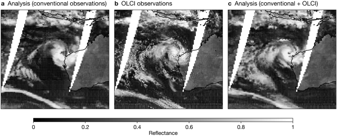
Experiments using a depleted observing system, which added OLCI visible reflectances to a baseline control using only conventional data, have shown significant improvements in model analysis and forecasts.
Revisiting the case study of tropical cyclone Sean in a depleted setting highlights the potential of visible observations (see Figure 7). Incorporating visible observations notably improved the analysis of the cyclone's structure and surrounding cloud fields.
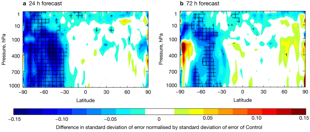
Depleted system experiments demonstrated that visible observations could not only enhance cloud analysis but could also improve initial conditions and forecasts of other key variables. Our results indicate that the most significant impacts of visible observations are on temperature and humidity. Moreover, the assimilation of visible observations in such scenarios could also improve wind forecasts (see Figure 8). Larger impacts were seen in the southern hemisphere, which was less observed by conventional observations and had more OLCI observations due to better observation coverage during the southern hemispheric summer.
These initial results are encouraging and build confidence that visible observations will be beneficial for future weather forecasts and climate reanalysis products. Importantly, historical broadband visible observations are available from as far back as the 1960/70s from missions such as Landsat, offering an invaluable long-term observational record of clouds to enhance future reanalysis datasets.
Outlook
Integrating visible reflectances into ECMWF's forecasting system through projects like CLOVIS, CAMEO, and CERTAINTY represents a substantial step forward for ECMWF and the global NWP community. The progress achieved emphasises the value of close collaborations with Member States, illustrated by DWD's leadership, bringing substantial mutual advantages to ECMWF and its users. Ongoing developments will improve our ability to analyse and simulate clouds and aerosols. Continued developments and operational integration of visible observations promise improvements in NWP analysis and forecast accuracy. To fully capitalise on visible data assimilation, crucial steps are needed to refine the assimilation and to improve model and operator performance. Leveraging historical visible satellite records dating back several decades presents an opportunity to enhance our understanding of clouds in past weather and climate conditions and to improve climate reanalyses. Successfully monitoring and assimilating visible satellite observations opens the door to exploiting the visible and near-infrared parts of the spectrum. These new capabilities not only advance all-sky data assimilation but also spark the imagination regarding new possibilities for understanding and predicting clouds and aerosols in ways previously unseen.
Further reading
Baur, F., L. Scheck, C. Stumpf, C. Köpken-Watts & R. Potthast, 2023: A neural-network-based method for generating synthetic 1.6 µm near-infrared satellite images, Atmos. Meas. Tech., 16, 5305-5326. https://doi.org/10.5194/amt-16-5305-2023
Benedetti, A., S. Quesada-Ruiz, J. Letertre-Danczak, M. Matricardi & G. Thomas, 2020: Progress towards assimilating visible radiances, ECMWF Newsletter No. 162, 10. https://www.ecmwf.int/en/newsletter/162/news/progress-towards-assimilating-visible-radiances
EUMETSAT, 2025: Satellite Application Facility for Numerical Weather Prediction (NWP SAF) RTTOV v14, https://nwp-saf.eumetsat.int/site/software/rttov/rttov-v14/.
Fielding, M., M. Janisková, S. Mason, R. Hogan, W. McLean, A. Benedetti et al., 2025, EarthCARE data begin to make an impact, ECMWF Newsletter No. 183, 21-27. https://doi.org/10.21957/65ds8j72mf
Geer, A.J. & P. Bauer, 2011: Observation errors in all-sky data assimilation, Q.J.R. Meteorol. Soc., 137, 2024-2037. https://doi.org/10.1002/qj.830
Necker, T., A. Benedetti, S. Quesada Ruiz & C. Lupu, 2025: Assimilation of Cloudy Visible Radiances (CIOVIS-2): Further steps towards establishing a Cloud Analysis in the Visible. Final report v0.3, available from ECMWF.
Scheck, L., M. Weissmann & L. Bach, 2020: Assimilating visible satellite images for convective-scale numerical weather prediction: A case-study. Q.J.R. Meterol. Soc., 146, 3165-3186. https://doi.org/10.1002/qj.3840
Scheck, L., 2021: A neural network based forward operator for visible satellite images and its adjoint, J. Quant. Spectrosc. Ra., 274, 107841. https://doi.org/10.1016/j.jqsrt.2021.107841
Steele, L., A. Benedetti, M. Matricardi, A. Geer & P. Lean, 2022: Initial results of monitoring cloudy visible radiances, ECMWF Newsletter No. 171, 7–8. https://www.ecmwf.int/en/newsletter/171/news/initial-results-monitoring-cloudy-visible-radiances