Society is naturally interested in extreme rainfall events and whether they can be predicted. This item looks at 14 such events from summertime 2023, from various model-output-related perspectives.
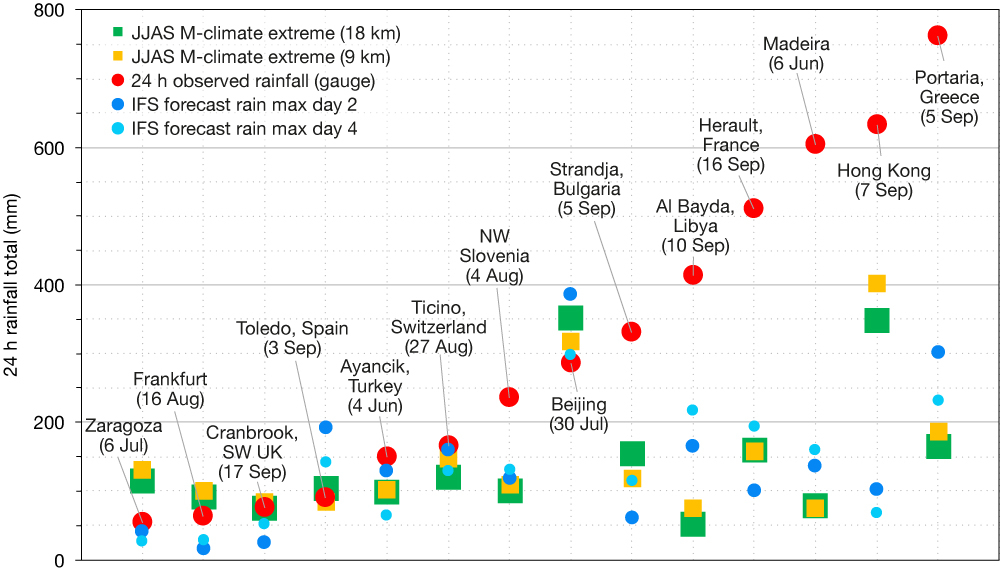
The scatterplot references 14 extreme rainfall events between June and September 2023, with red markers showing 24‑hour totals from single rain gauges, selected to try to represent ‘peak rainfall’ for each event. The main basis for selection was media reports of flooding events, which varied in severity. Whilst manual quality control of gauge data has been applied, errors probably still exist. These concern, for example, the measurement start/end times, which can sometimes be hard to disentangle. Probably for all events, the true peak rainfall was also higher than shown, due to imperfect data coverage. For example, whilst the Madeira value should be representative, due to very high gauge density, the Libya total is probably a large underestimate, due to lack of observations.

ECMWF’s performance
The first question we then pose is: was ECMWF’s Integrated Forecasting System (IFS), in ensemble form, able to foresee these events? To answer, we show with blue markers the maximum forecast 24 h rainfall value for the nearest IFS grid point, using a lighter shade for a 4‑day lead, and darker for a 2‑day lead. In each case, 52 medium-range runs from the same start time are referenced, for 3x24 h periods of validity that start at 12 UTC the day before the valid date, and 00 and 12 UTC on that date. In this way, we allow for uncertainty in rainfall report timing, and/or accommodate IFS forecast timing errors. These can thus be considered wet outlier forecasts for the said events. For a set of forecast runs to be quantitatively useful, in advising a forecaster what rainfall amounts to allow for in any warnings, values need to be greater than what was observed, so that the eventual outcome lies within the ensemble range. This criterion is met for only two cases – the Toledo and Beijing events. Meanwhile one can also see, somewhat surprisingly, that day 2 forecasts are no better overall, by this metric, than day 4. One possible interpretation is that synoptic patterns are already well captured at day 4, and that ensemble perturbations, perhaps mainly those that arise from the stochastic physics, are then causing just semi-random oscillations in the most extreme rainfall within the ensemble.
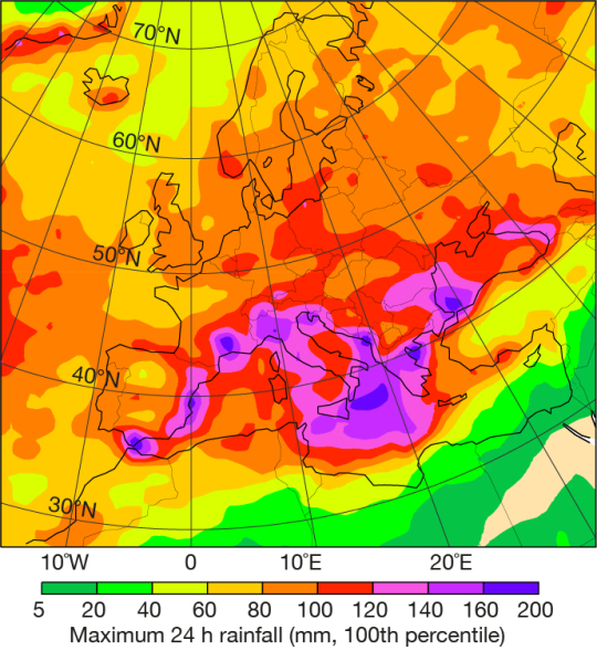
Of course, it has long been recognised that gridbox rainfall values from a model cannot represent localised extremes at point scale, because of factors such as sub-grid variability and biases, both of which depend on the situation (geographical and meteorological). The finer the resolution of the model, the smaller any shortfall should be. So what resolution is required to capture point-relevant variability? The European map plot shows the top value in 15,000 realisations from 20 years of operational re-forecasts, at 9 km resolution (IFS Cycle 48r1), indicating a propensity for higher extremes in southern Europe. On the scatterplot, we show with squares, for the designated locations, these model-climate extremes as reference points for the depicted forecasts, for 9 km (yellow) and 18 km (green, Cycle 47r3) resolutions. Whilst 9 km resolution delivers marginally higher extremes than 18 km, overall the difference is smaller than one might expect. The reason is probably model physics changes in 48r1, which reduced rainfall in some net sense to address a known, global, over-prediction bias. Where forecast values lie above these thresholds, it can act as an alert that something very extreme may happen (without indicating likely values). This behaviour can be seen for about five of the 14 cases, which include three of the wettest five events. Indeed, this type of comparison strategy underpins the EFI (Extreme Forecast Index) and SOT (Shift Of Tails) metrics, which are widely used to anticipate extreme weather. So, whilst there is a huge shortfall in absolute rainfall values forecast in some cases, the fact that the top value in re-forecasts was sometimes exceeded does show intrinsic forecast value. The Hong Kong event is an exception – here the forecast was not that extreme for that location (and indeed the corresponding ensemble mean was only 20 mm), yet the Hong Kong Observatory still registered its wettest 24 h period since 1889.

If a rainfall value denotes a very isolated peak, then extreme impacts can be less widespread, and the forecast error can be deemed acceptable. However, if values are not forecast and are more typical of a wider area encompassing several model grid boxes (as in the Hong Kong case), then the model is exhibiting more worrying error behaviour, on its own grid scales. For the top-ranked Greece event, the observation figure for the rainfall event on 5 September 2023 suggests that the extraordinary values >500 mm were relatively isolated, and that 200–300 mm, as predicted for Portaria, was more typical to the west. However, we should not underplay the societal impacts, which were exceptional and widespread for this case. Also, this is only a segment of what was a multi-day event in Greece.

Possible remedies
So how can we address the IFS shortfalls in representing local rainfall extremes? Currently one can use post-processed ecPoint output, that aims to predict values, probabilistically, at rain gauge scale. Presently only 12 h totals are available, although 6 h and 24 h fields are in development. Or one can use higher-resolution limited-area ensembles, which are quite commonplace in Europe. In the longer term, ECMWF will run higher-resolution global models operationally, and a key ‘testbed’ for this is the experimental (4.4 km) runs from the EU-funded Destination Earth (DestinE) initiative. These have been trialled on many of the cases described here, and first results look quite promising.
