July and August 2023 were in Europe characterised by two major heatwaves in the south, while northern Europe saw a lot of rain with floodings in Norway and Sweden. The July heatwave affected countries around the Mediterranean Sea, with major wildfires in Greece and other countries, while the August heatwave affected south-western Europe (Spain, France, Switzerland). In this article, we will focus on the predictability of the August heatwave. During this heatwave, the city of Lyon in France saw 17 days in a row with temperatures above 30°C (9–25 August), which peaked at 41.4°C on 24 August. In Spain, Bilbao on the north coast set a new record of 44.0°C on 23 August.
Extended-range forecasts
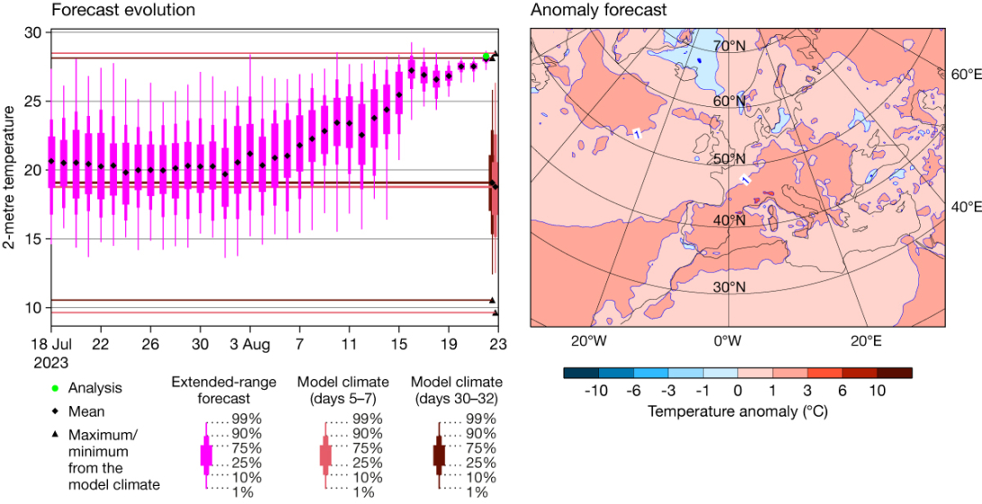
Starting with the extended-range predictions of the peak of the heatwave (22–24 August) for south-eastern France (in a box from 44°N to 46°N and 4°E to 6°E), we find that, as early as 30 days before the peak, the ensemble mean was slightly shifted (1°C) above the model climate mean (see the forecast evolution plot). As extended-range forecasts can be affected by growing model biases, the plot also includes the model climate for days 30–32, in addition to days 5–7. However, no major differences for this area are present for the model climate distributions.

Around 20 days before the peak, the ensemble mean gradually started to be warmer than the model climate mean. This can be seen in the chart showing weekly mean temperature anomalies in the extended-range forecast from 7 August, which were above three degrees over parts of southern France. As the forecast evolution plot shows, the ensemble mean crossed the 99th percentile of the model climate on 16 August, six days before the start of the 3‑day evaluation period. The 3‑day ensemble mean temperature of the last forecast was close to the model climate maximum and also to the mean of the 166 observation stations in the area. As the model climate is based on re‑forecasts from the past 20 years, one should note that it includes the August 2003 heatwave, which explains the existing extreme of comparable severity in the model climate in the same area.
Medium-range forecasts
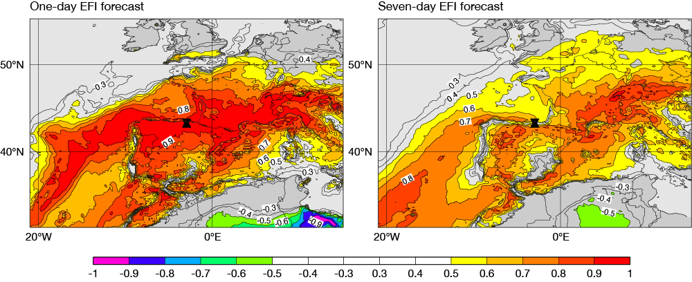
Looking at the medium-range prediction of the maximum temperature on 23 August, we find values of the Extreme Forecast Index (EFI) of 0.8 and above in the region of south-eastern France and Switzerland, in the forecast from 17 August 00 UTC. However, along the northern coast of Spain and the southern part of the French Atlantic coast, no such extreme was indicated in the EFI forecast from that date, although it is captured in a 1‑day forecast (see the EFI charts for 23 August in 1- and 7‑day forecasts).

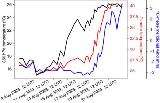
To understand the evolution of the prediction for maximum temperature along the Atlantic coast, we have investigated the prediction of 2‑metre temperature (t2m), 850 hPa temperature (T850) and 10‑metre meridional wind (v10m) for Bilbao. For the T850 we find a relatively smooth evolution of the signal, which is above 25°C on 20 August 00 UTC (see the figure showing the evolution of ensemble means). This predictability is in line with what is seen for the 3‑day temperature over southeastern France above. However, for forecasts from before 21 August, most ensemble members predicted a northerly component of the surface winds, leading to onshore winds and relatively mild temperatures in the forecast. The error in the flow observed around 20 August was probably related to a trough east of Portugal that was underestimated in the forecast. The winds from the sea in the forecasts cooled the lower part of the troposphere. Only with the change to a southerly wind direction did the ensemble become really extreme for Bilbao.

Conclusion
To summarise, the predictability of the August heatwave over south-western Europe was good, with a signal appearing already in the extended range. However, due to errors in the winds along the Atlantic coast of Spain and France, the extreme surface temperature was missed in those locations in medium-range predictions, despite a good signal in 850 hPa temperature.
For heatwaves, one must remember that many aspects play a role for the severity for human health, such as minimum temperatures and the duration of the heatwave. During the August heatwave, temperatures at night (00 UTC) over south-eastern France were up to 8°C above climatology. This was compounded by very high temperatures (> 20°C at 00 UTC) at night for more than eight days in a row. Unusually high temperatures and their persistence in time may be detrimental to human health as they imply a sustained lack of respite from daytime hot conditions at night. High humidity can also be detrimental because it reduces the rate of sweat evaporation and thus makes it difficult to regulate the body's temperature. To consider the effect of air temperature, humidity and other weather factors from a human health perspective, ECMWF has been producing heat stress indices from the ERA5 reanalysis, with plans to generate operational forecasts too.
For more details on this case, see the ECMWF Severe Event Catalogue: https://confluence.ecmwf.int/display/FCST/202308+-+Heatwave+-+South-Western+Europe