During February and March, several events of significant dust transport from the Sahara affected Europe. The most notable events were around 6–9 February, 2–4 March and 30–31 March. Such episodes can affect solar radiation in a direct way, through reflection and absorption of solar radiation, and in an indirect way, by solar absorption leading to temperature changes affecting cloud formation or by dust acting as ice nuclei. These effects can lead to cooler 2-metre temperatures and reduced solar power production. Dust particles can also have a negative impact on health. Forecasts by the EU-funded Copernicus Atmosphere Monitoring Service (CAMS) implemented by ECMWF include a prediction of dust and its radiative impacts and captured the dust events well. However, ECMWF's weather forecasts only represent dust as a seasonally varying climatology and therefore cannot yet capture the effects of specific dust events.
End of March forecasts
At the end of March, the synoptic situation over Europe was characterised by a blocking anticyclone centred over the central parts of the continent. In its western fringe, an active trough triggered an episode of intense transport of Saharan dust affecting parts of western Europe. The dust reached as far north as southern England and had a noticeable effect on the weather over the affected areas. It considerably reduced visibility in the boundary layer over southwestern parts of the Iberian Peninsula, affecting air quality, and it reduced the incoming direct solar radiation, affecting 2-metre temperature. Forecasts and analyses of aerosol optical depth (AOD) at 550 nm from CAMS clearly showed the dust plume transport along the western edge of the anticyclone, from northwestern Africa and across the Iberian Peninsula, from 29 to 31 March. The CAMS AOD forecast initialized on 27 March and valid for 30 March captured well the general transport of the dust plume across the region (see the figure on the CAMS analysis/forecast of AOD).
During this episode, ECMWF's high-resolution forecast (HRES) experienced large temperature errors over the dust-affected areas of the Iberian Peninsula. Even in the short-range 12-hour forecast for 2-metre temperature, the model was 2 to 7ºC warmer than the observations (see the figure on temperature forecast errors).
The temperature error could be due to several reasons, including a misrepresentation of dust or cloud in the model forecast. Mainly for reasons of computational cost, the HRES and the ensemble forecast (ENS) do not predict the day-to-day variation in dust or other aerosols, but instead use a seasonally varying climatology of aerosol species, based on an earlier version of the CAMS system. HRES and ENS therefore cannot capture the impact of dust episodes on the meteorology or on forecast visibility. However, the operational CAMS system does run the ECMWF Integrated Forecasting System (IFS) in a configuration for forecasting atmospheric composition and chemistry including aerosols (sources, sinks and advection of aerosol species) with direct impacts on the radiation in the model. Comparing meteorological fields from the CAMS operational output with the output from a CAMS control configuration which uses the aerosol climatology of HRES and ENS allows us to evaluate the direct radiative impact of dust plumes on parameters such as 2-metre temperatures.

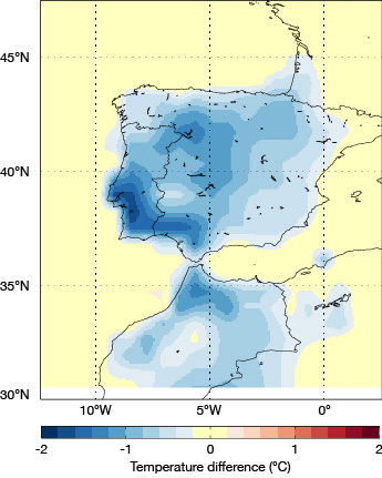
For the dust plume across the Iberian Peninsula on 30 March, the comparison showed a reduction in the afternoon (12:00-15:00 UTC) average 2-metre temperature of between 1.2 and 1.8ºC (see the figure on the prognostic aerosol impact on 2-metre temperature).
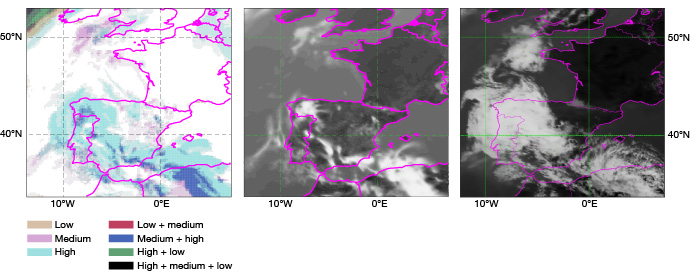
This result indicates that the radiative effect of a lack of dust contributed to the temperature error. However, there was also too little high cloud in HRES associated with an upper level front in the southerly air flow (see the figure on cloud cover). Although the HRES forecast high cloud cover over the region, it was too thin with insufficient ice water content, giving too weak a signal in the infrared simulated satellite image (see simulated and real satellite images). This allows too much shortwave radiation to reach the surface and therefore also contributes significantly to the warm bias in the 2-metre temperature in this case. It is not yet clear if the cloud error is related to errors in vertical motions in the upper level frontal zone, or a too dry upper troposphere, or whether missing aerosol interactions in the model play a role. Too little radiative impact of the upper level cloud field has also been observed in other similar southerly flow situations, and an investigation over a larger set of cases is needed to further understand any systematic cloud errors in these conditions.
Conclusion
Users of ECMWF forecasts (HRES and ENS) need to be aware of the use of a dust climatology in the forecasts and therefore of the lack of impact on shortwave radiation reaching the surface, 2-metre temperature and visibility during significant dust events. CAMS forecasts allow us to assess the impact of dust events like this one and demonstrates the potential for including prognostic aerosols in the IFS. Doing so in a cost-efficient way is being considered as a future development.
