Datasets

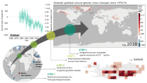
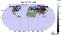
The DestinE Digital Twin for Climate Change Adaptation (Climate DT) supports adaptation activities by providing innovative climate information on multi-decadal timescales, globally, at scales at which many impacts of climate change are observed. It combines cutting-edge global Earth-system models, impact-sector applications and observations into a unified framework to provide global climate projections and impact-sector information on multi-decadal timescales (1990 to ~2050), at very high spatial resolutions (5 to 10 km).
Interval/period: N/A

These daily and monthly data are pre-calculated and have the following types depending on the variables: daily and monthly averages, extremes and totals.
Interval/period: Sat, 09/01/1990 - Sat, 02/28/2026
Interval/period: Wed, 01/01/1975 - Sat, 07/04/2026
Interval/period: Wed, 01/01/2003 - Sat, 12/31/2022
Interval/period: Wed, 01/01/1992 - Sat, 07/04/2026
Interval/period: Sun, 10/01/2017 - Sat, 07/04/2026

Interval/period: Tue, 10/01/1985 - Wed, 12/31/2025

Interval/period: Sun, 09/01/1985 - Wed, 12/31/2025
Interval/period: Tue, 01/02/1979 - Sat, 07/04/2026
Interval/period: Thu, 01/01/1998 - Fri, 12/31/2010
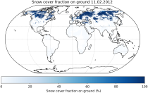
It provides Level 3 collated (L3C) processed products, namely global daily single-sensor Snow cover fraction viewable (SCFV) and Snow cover fraction on ground (SCFG) products, both of which are based on optical satellite data.
Interval/period: Fri, 01/01/1982 - Tue, 09/30/2025