This dataset provides daily mid-morning measurements for Lake Surface Water Temperature (LSWT) derived from satellite observations. LSWT, together with five other variables (lake ice cover and thickness, water leaving reflectance, water level and extent) is recognised as the Essential Climate Variable (ECV) "Lakes" by the Global Climate Observing System (GCOS). LSWT is a key parameter in determining lake ecological conditions as it influences physical, chemical and biological processes.

calendar_today Interval/period: Thu, 06/01/1995 - Tue, 05/12/2026

This dataset provides lake water levels for 311 selected lakes on four continents derived from satellite radar altimetry.

calendar_today Interval/period: Wed, 01/01/1992 - Tue, 05/12/2026

The Essential Climate Variables for assessment of climate variability from 1979 to present dataset contains a selection of climatologies, monthly anomalies and monthly mean fields of Essential Climate Variables (ECVs) suitable for monitoring and assessment of climate variability and change. Selection criteria are based on accuracy and temporal consistency on monthly to decadal time scales.

calendar_today Interval/period: Mon, 01/01/1979 - Wed, 04/01/2026

The dataset presents climate impact indicators related to extreme precipitation in Europe under current climate conditions. The suite of indicators include recent historic records, recurrence intervals, and other relevant statistical measures to evaluate the magnitude and frequency of extreme precipitation events. These are provided as gridded products, with one product covering the whole of Europe, and the other higher resolution product focused on 20 European cities that were identified as vulnerable to urban pluvial flooding based on stakeholder surveys.

calendar_today Interval/period: Sun, 01/01/1950 - Tue, 12/31/2019

The C3S Arctic Regional Reanalysis second generation (CARRA2) dataset contains daily and monthly meteorological variables at 2.5 km resolution. These variables are specified at single levels (including surface) and also at soil, height, pressure and model levels. These daily and monthly data are pre-calculated and have the following types depending on the variables: daily and monthly averages, extremes and totals.

calendar_today Interval/period: Wed, 01/01/1986 - Sun, 12/31/2023

The C3S Arctic Regional Reanalysis second generation (CARRA2) dataset contains 3-hourly analyses at 2.5 km resolution. These variables are specified at single levels (including surface) and also at soil, height, pressure and model levels. Additionally, hourly forecasts are available between the analysis times and particularly forecasts up to 18 hours initialised from the analyses at 00 and 12 UTC.

calendar_today Interval/period: Wed, 01/01/1986 - Sun, 12/31/2023

Within the hydrological cycle, precipitation is the main component of water transport from the atmosphere to the Earth’s surface. Precipitation varies strongly, depending on geographical location, season, synopsis, and other meteorological factors. The supply of freshwater through precipitation is vital for many subsystems of the climate and the environment, but there are also hazards related to extensive precipitation or the lack of precipitation.

calendar_today Interval/period: Mon, 01/01/1979 - Mon, 09/30/2024

This dataset provides global estimates of daily accumulated and monthly means of precipitation. The precipitation estimates are based on a merge of passive microwave observations from two different radiometer classes operating on multiple Low Earth Orbit (LEO) satellites.

calendar_today Interval/period: Sat, 01/01/2000 - Sun, 12/31/2017

The UERRA dataset provides estimations of the climate in Europe based on model data
combined with observations using the UERRA-HARMONIE system and MESCAN-SURFEX system.
UERRA-HARMONIE is a 3-dimensional data assimilation system, whereas
MESCAN-SURFEX is a complementary surface analysis system. In general, the
assimilation systems are able to estimate biases between observations and to
sift good-quality data from poor data. The laws of physics allow for estimates

calendar_today Interval/period: Thu, 10/18/2018 - Wed, 07/31/2019

The DestinE Digital Twin for Weather-Induced Extremes (Extremes DT) supports responding and adapting to extreme events in a changing world by providing a capability to produce tailored simulations and address what-if scenarios related to extreme events in a past, present and future climate, complementing existing capabilities at national and European level.

calendar_today Interval/period: N/A

This dataset provides gridded modelled hydrological time series forced with medium-range meteorological forecasts. The data is a consistent representation of the most important hydrological variables across the European Flood Awareness System (EFAS) domain. The temporal resolution is sub-daily high-resolution and ensemble forecasts of:

River discharge
Volumetric soil moisture
Snow water equivalent
Soil wetness index (root zone)
Runoff water equivalent (surface plus subsurface)

calendar_today Interval/period: Thu, 10/11/2018 - Mon, 04/06/2026

open_in_newview in EWDS

This dataset provides gridded modelled hydrological time series forced with medium-range meteorological forecasts. The data is a consistent representation of the most important hydrological variables across the European Flood Awareness System (EFAS) domain. The temporal resolution is sub-daily high-resolution and ensemble forecasts of:

River discharge
Soil moisture for three soil layers
Snow water equivalent

calendar_today Interval/period: N/A

This dataset provides an ensemble of forecast time series of gridded hydrological data. The data set is a product of the Global Flood Awareness System (GloFAS) and offers a consistent representation of key hydrological variables across the global domain including:

River discharge
Soil wetness index (root zone)
Snow water equivalent
Runoff water equivalent (surface plus subsurface)

calendar_today Interval/period: Tue, 11/05/2019 - Thu, 05/07/2026

open_in_newview in EWDS
This dataset provides gridded modelled sub-daily and daily hydrological time series forced with meteorological observations. The data set is a consistent representation of the most important hydrological variables across the European Flood Awareness System (EFAS) domain. The temporal resolution is up to 30 years modelled time series of:

River discharge
Volumetric soil moisture
Snow water equivalent
Soil wetness index (root zone)
Runoff water equivalent (surface plus subsurface)

calendar_today Interval/period: Tue, 01/01/1991 - Tue, 05/05/2026

This dataset provides gridded modelled daily hydrological time series forced with meteorological reanalysis data. The data set is a product of the Global Flood Awareness System (GloFAS) and offers a consistent representation of key hydrological variables across the global domain including:

River discharge
Soil wetness index (root zone)
Snow water equivalent
Runoff water equivalent (surface plus subsurface)

calendar_today Interval/period: Mon, 01/01/1979 - Tue, 05/05/2026

This dataset provides gridded modelled hydrological time series forced with medium- to sub-seasonal range meteorological reforecasts. The data is a consistent representation of the most important hydrological variables across the European Flood Awareness System (EFAS) domain. The temporal resolution is 20 years of sub-daily reforecasts initialised twice weekly (Mondays and Thursdays) of:

River discharge
Volumetric soil moisture
Snow water equivalent
Soil wetness index (root zone)
Runoff water equivalent (surface plus subsurface)

calendar_today Interval/period: Wed, 10/14/2020 - Tue, 05/12/2026

This dataset provides a gridded modelled time series of river discharge, forced with medium- to sub-seasonal range meteorological reforecasts. The data is a consistent representation of a key hydrological variable across the global domain, and is a product of the Global Flood Awareness System (GloFAS). It is accompanied by an ancillary file for interpretation that provides the upstream area (see the related variables table and associated link in the documentation).

calendar_today Interval/period: Sun, 01/03/1999 - Sat, 11/25/2023

ERA5–Drought is a global reconstruction of drought indices from 1940 to present.
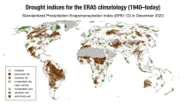
The dataset comprises two standardised drought indices:
- the Standardised Precipitation Index (SPI)
- the Standardised Precipitation-Evapotranspiration Index (SPEI).

calendar_today Interval/period: Mon, 01/01/1940 - Sun, 03/01/2026

This dataset provides meteorological and snow indicators for Europe, characterizing operating conditions of winter ski resorts under past and future climate scenarios. The dataset consists of 39 indicators of atmospheric and snow conditions computed in a similar manner for all mountain regions in Europe at the scale of NUTS-3 regions (Nomenclature of Territorial Units for Statistics) and by steps of 100 m elevation.

calendar_today Interval/period: Sun, 01/01/1950 - Fri, 01/01/2100

This dataset provides hydrological seasonal forecasts of monthly mean river discharge across Europe. Two hydrological model ensembles are provided. The first is an E-HYPE multi-model system comprising eight model realisations using a catchment-based resolution. The second comprises the E-HYPEgrid, VIC-WUR and EFAS (LISFLOOD) hydrological models at a 5km gridded resolution.

calendar_today Interval/period: Tue, 12/01/2020 - Wed, 04/01/2026

This dataset provides hydrological seasonal reforecasts of monthly mean river discharge across Europe for the period 1993 to 2016. The first is an E-HYPE multi-model system comprising eight model realisations using a catchment-based resolution. The second comprises the E-HYPEgrid, VIC-WUR and LISFLOOD-EFAS hydrological models at a 5km gridded resolution.

calendar_today Interval/period: Fri, 01/01/2021 - Tue, 05/12/2026

The nextGEMS data is aligned with the Climate Change Adaptation Digital Twin. The DestinE Digital Twin for Climate Change Adaptation (Climate DT) supports adaptation activities by providing innovative climate information on multi-decadal timescales, globally, at scales at which many impacts of climate change are observed.

calendar_today Interval/period: N/A

The daily and monthly data of the C3S Arctic Regional Reanalysis (CARRA) dataset contains daily and monthly meteorological variables at 2.5 km resolution. This includes fields at the single levels (including surface) and on pressure, height, soil and model levels.
These daily and monthly data are pre-calculated and have the following types depending on the variables: daily and monthly averages, extremes and totals.

calendar_today Interval/period: Sat, 09/01/1990 - Sat, 02/28/2026

ERA5-Land is a reanalysis dataset providing a consistent view of the evolution of land variables over several decades at an enhanced resolution compared to the
Fifth Generation of the European Centre for Medium-Range Weather Forecasts (ECMWF) Reanalysis (ERA5).
Produced by replaying only the land component of the ECMWF ERA5 climate reanalysis, it benefits from the same physical data-assimilation framework but runs offline at
higher spatial detail (9 km grid) to deliver richer land-surface information.

calendar_today Interval/period: Sun, 01/01/1950 - Thu, 12/31/2026