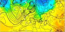
In the northern hemisphere the air rotates anti-clockwise around low contour centres and clockwise around the high contour centres. In the southern hemisphere the air rotates clockwise around low contour centres and ...

calendar_today Interval/period: N/A

open_in_newview in Open Charts

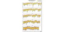
These diagrams compare scores of ensemble control (red) and ensemble members (central 50% of ...

calendar_today Interval/period: N/A

open_in_newview in Open Charts

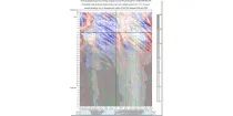
This is a time/longitude diagram (Hovmoller diagram) of 500 hPa or 1000 hPa mean height anomaly ...

calendar_today Interval/period: N/A

open_in_newview in Open Charts

**Note:** In **June 2023** ECMWF implemented a **major upgrade ...**

calendar_today Interval/period: N/A

open_in_newview in Open Charts

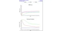
These plots compare recent IFS and experimental AIFS daily verification scores for 500 hPa ...

calendar_today Interval/period: N/A

open_in_newview in Open Charts
The dataset provides global annual glacier mass changes distributed on a global regular grid at 0.5° resolution (latitude, longitude) based on the Fluctuations of Glaciers (FoG) database of the World Glacier Monitoring Service (WGMS). Glaciers play a fundamental role in the Earth’s water cycles. They are one of the most important freshwater resources for societies and ecosystems and the recent increase in ice melt contributes directly to the rise of ocean levels.

calendar_today Interval/period: Wed, 01/01/1975 - Tue, 05/12/2026

This dataset, commonly known as the Randolph Glacier Inventory (RGI), provides global glacier outlines compiled from maps, aerial photographs and satellite images. The data is provided as a "snapshot" (single time-slice) constructed from images that were mostly acquired in the period 2000-2010.

calendar_today Interval/period: Sat, 01/01/2000 - Sun, 12/31/2000

This dataset provides a complete archive of monthly mass change timeseries for the drainage basins of the Antarctic and Greenland Ice Sheets from NASA's Gravity Recovery and Climate Experiment (GRACE) and GRACE Follow On (GRACE-FO) mission, which have operated from 2002 to current data.

calendar_today Interval/period: Wed, 01/01/2003 - Sat, 12/31/2022

This dataset provides estimates of surface elevation change over the Greenland and Antarctic ice sheets since 1992, utilizing satellite radar altimetry from five missions: ERS-1, ERS-2, ENVISAT, CryoSat-2, and Sentinel-3A. The surface elevation change is modelled over successive, overlapping periods and reported monthly.

calendar_today Interval/period: Wed, 01/01/1992 - Tue, 05/12/2026

This dataset provides annual ice velocity maps of the Greenland and Antarctic Ice Sheets derived from Sentinel-1 data. The product represents the current state-of-the-art in Europe for satellite-based ice velocity data records. It follows from the European Space Agency (ESA) Climate Change Initiative (CCI) and is guided by the Global Climate Observing System (GCOS) targets for the Ice Sheets Essential Climate Variable (ECV).

calendar_today Interval/period: Sun, 10/01/2017 - Tue, 05/12/2026

Snow water equivalent (SWE) is an important variable indicating the amount of accumulated snow on land surfaces. SWE describes the amount of liquid water in a snowpack that would be formed if the snowpack was completely melted. This dataset is useful for monitoring snow conditions, freshwater storage, and climate studies. It provides daily estimates of SWE for the Northern Hemisphere from 1979 to present derived from passive microwave radiometer (PMR) measurements onboard polar-orbiting satellites.

calendar_today Interval/period: Tue, 01/02/1979 - Tue, 05/12/2026