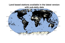
Datasets
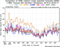
The dataset has been available since October 2006. TIGGE was established as a key component of THORPEX: a World Weather Research Programme to accelerate the improvements in the accuracy of 1-day to 2 week high-impact weather forecasts (THORPEX stands for THe Observing system Research and Predictability EXperiment)
Interval/period: Sun, 10/01/2006 - Wed, 05/06/2026

Interval/period: Sun, 01/01/1950 - Fri, 12/31/2100
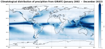
Interval/period: Tue, 01/01/2002 - Sat, 12/31/2022
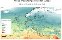
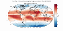
Interval/period: Mon, 01/01/1979 - Mon, 12/31/2018
Interval/period: Sun, 01/01/1950 - Tue, 05/12/2026
Interval/period: Mon, 01/01/1979 - Sun, 02/01/2026
Interval/period: Wed, 01/01/1975 - Tue, 05/12/2026
Interval/period: Sat, 01/01/2000 - Sun, 12/31/2000
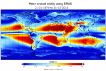
Interval/period: Mon, 01/01/1979 - Mon, 12/31/2018
Interval/period: Sun, 01/01/1978 - Wed, 10/17/2018
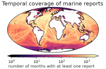
and naval ships, drifting buoys and other platforms and vessels over
the global ocean. Data have been collated and harmonised and quality control checks have been performed, but no attempt
has been made to assess or correct for potential biases.
Data are provided for a range of commonly observed variables.
Interval/period: Tue, 01/01/1850 - Tue, 05/12/2026
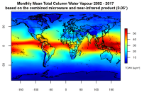
This catalogue entry presents two extensive, high-quality observational datasets of TCWV, specifically tailored for climate analysis and applications.
Interval/period: Tue, 01/01/2002 - Sun, 12/31/2017
Interval/period: Mon, 01/01/1951 - Sat, 12/31/2050
Interval/period: Sun, 01/01/1950 - Sat, 12/31/2050
Interval/period: Fri, 07/13/1979 - Tue, 04/21/2026
Interval/period: Wed, 01/01/2003 - Sat, 12/31/2022
Interval/period: Sun, 01/01/1860 - Mon, 12/31/2300
Interval/period: Sun, 01/01/1860 - Mon, 12/31/2300
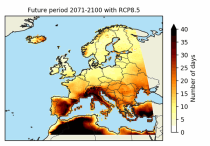
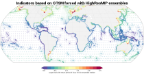
These heat wave and cold spell days are available for different future time periods and use different climate change scenarios.
Interval/period: Wed, 01/01/1986 - Mon, 12/31/2085
Interval/period: Mon, 01/01/2018 - Tue, 12/31/2024
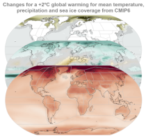
ECV datasets provide the empirical evidence needed to understand the current climate and predict future changes.
Interval/period: N/A
Interval/period: Wed, 01/01/1992 - Tue, 05/12/2026
Interval/period: Sun, 10/01/2017 - Tue, 05/12/2026

Interval/period: Sun, 01/01/2017 - Fri, 05/01/2026
Interval/period: Sun, 01/01/2017 - Fri, 05/01/2026