Datasets

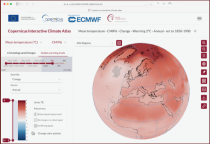
CMIP6 data underpins the Intergovernmental Panel on Climate Change 6th Assessment Report. The use of these data is mostly aimed at:
addressing outstanding scientific questions that arose as part of the IPCC reporting process;
improving the understanding of the climate system;
Interval/period: Sun, 01/01/1860 - Mon, 12/31/2300
Interval/period: Tue, 01/01/2013 - Tue, 12/31/2024
Interval/period: Wed, 01/01/2003 - Wed, 12/03/2025
Interval/period: Sat, 01/01/2000 - Thu, 12/31/2020
Interval/period: Wed, 01/01/2003 - Thu, 12/31/2020
Interval/period: Wed, 01/01/2003 - Thu, 12/31/2020
Interval/period: Mon, 01/01/1979 - Wed, 12/31/2025
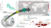
Interval/period: Mon, 01/01/1979 - Mon, 12/31/2018
Interval/period: Sun, 01/01/1950 - Sun, 07/05/2026
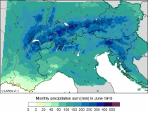
LAPrec1871 starts in 1871 and is based on data from 85 input series;
LAPrec1901 starts in 1901 and is based on data from 165 input series.
Interval/period: Sun, 01/01/1871 - Sun, 07/05/2026

These daily and monthly data are pre-calculated and have the following types depending on the variables: daily and monthly averages, extremes and totals.
Interval/period: Sat, 09/01/1990 - Sat, 02/28/2026

Interval/period: Sat, 01/01/2000 - Sun, 12/31/2017
ECV datasets provide the empirical evidence needed to understand the current climate and predict future changes.
CIIs contain condensed climate information which facilitate relatively quick and efficient subsequent analysis. Therefore, CIIs make climate information accessible to application focussed users within a sector.
Interval/period: N/A
Interval/period: Thu, 01/01/1750 - Fri, 01/01/2021
Interval/period: Wed, 01/01/1986 - Mon, 12/31/2085
Interval/period: Wed, 01/01/1975 - Sun, 07/05/2026
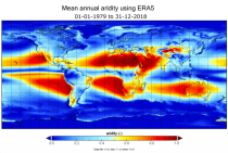
Interval/period: Mon, 01/01/1979 - Mon, 12/31/2018
Interval/period: Sat, 01/01/1718 - Thu, 02/26/2026
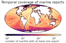
and naval ships, drifting buoys and other platforms and vessels over
the global ocean. Data have been collated and harmonised and quality control checks have been performed, but no attempt
has been made to assess or correct for potential biases.
Data are provided for a range of commonly observed variables.
Interval/period: Tue, 01/01/1850 - Sun, 07/05/2026
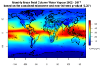
This catalogue entry presents two extensive, high-quality observational datasets of TCWV, specifically tailored for climate analysis and applications.
Interval/period: Tue, 01/01/2002 - Sun, 12/31/2017
Interval/period: Mon, 01/01/1951 - Sat, 12/31/2050
Interval/period: Sun, 01/01/1950 - Sat, 12/31/2050
Interval/period: Wed, 01/01/2003 - Sat, 12/31/2022
Interval/period: Sun, 01/01/1860 - Mon, 12/31/2300
Interval/period: Sun, 01/01/1860 - Mon, 12/31/2300