Datasets

Interval/period: Sun, 01/01/1950 - Tue, 12/31/2019

combined with observations using the UERRA-HARMONIE system and MESCAN-SURFEX system.
UERRA-HARMONIE is a 3-dimensional data assimilation system, whereas
MESCAN-SURFEX is a complementary surface analysis system. In general, the
assimilation systems are able to estimate biases between observations and to
sift good-quality data from poor data. The laws of physics allow for estimates
Interval/period: Thu, 10/18/2018 - Wed, 07/31/2019
Interval/period: Thu, 02/01/1940 - Fri, 01/23/2026
Interval/period: Sat, 03/01/1986 - Wed, 11/30/2011

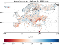
River discharge
Volumetric soil moisture
Snow water equivalent
Soil wetness index (root zone)
Runoff water equivalent (surface plus subsurface)
Interval/period: Thu, 10/11/2018 - Mon, 04/06/2026

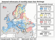
River discharge
Volumetric soil moisture
Snow water equivalent
Soil wetness index (root zone)
Runoff water equivalent (surface plus subsurface)
Interval/period: Tue, 01/01/1991 - Tue, 05/05/2026

River discharge
Volumetric soil moisture
Snow water equivalent
Soil wetness index (root zone)
Runoff water equivalent (surface plus subsurface)
Interval/period: Wed, 10/14/2020 - Mon, 05/11/2026
LAPrec1871 starts in 1871 and is based on data from 85 input series;
LAPrec1901 starts in 1901 and is based on data from 165 input series.
Interval/period: Sun, 01/01/1871 - Mon, 05/11/2026
Interval/period: Sat, 09/01/1984 - Sat, 01/31/2026
Interval/period: Sat, 09/01/1984 - Sat, 01/31/2026
Interval/period: Sat, 09/01/1984 - Sat, 01/31/2026

Interval/period: Sat, 09/01/1984 - Thu, 07/31/2025
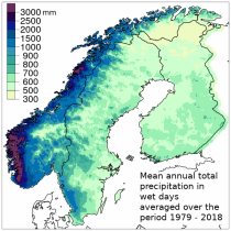
Interval/period: Mon, 01/01/1979 - Sun, 03/01/2026
Interval/period: N/A

Interval/period: Sun, 01/01/1950 - Wed, 12/01/2100

Interval/period: Mon, 01/01/1940 - Fri, 12/31/2100

Interval/period: Sun, 01/01/1950 - Fri, 12/31/2100
Interval/period: Sun, 01/01/1950 - Mon, 05/11/2026
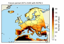
These heat wave and cold spell days are available for different future time periods and use different climate change scenarios.
Interval/period: Wed, 01/01/1986 - Mon, 12/31/2085
Interval/period: Mon, 01/01/2018 - Tue, 12/31/2024

ECV datasets provide the empirical evidence needed to understand the current climate and predict future changes.
Interval/period: N/A
Interval/period: Sun, 01/01/1950 - Fri, 01/01/2100
Interval/period: Tue, 12/01/2020 - Wed, 04/01/2026
Interval/period: Fri, 01/01/2021 - Mon, 05/11/2026
Spatial interpolation methods are applied to observational datasets to create gridded datasets.
In general, there are three types of such methods: deterministic (type 1), stochastic (type 2) and pure mathematical (type 3).
Interval/period: Sun, 01/01/1961 - Thu, 09/18/2025