Datasets
Displaying 1 - 4 of 4
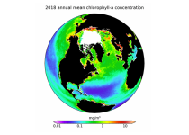
This dataset provides global daily estimates of ocean surface chlorophyll-a concentration and remote sensing reflectance derived from multiple satellite sensors. These two products are part of the broader discipline of ocean colour remote sensing, which analyses ocean surface radiances measured from space to derive information about the optical properties and constituents of the upper ocean.
Interval/period: Thu, 09/04/1997 - Tue, 12/31/2024
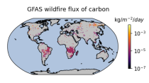
Emissions of atmospheric pollutants from biomass burning and vegetation fires are key drivers of the evolution of atmospheric composition, with a high degree of spatial and temporal variability, and an accurate representation of them in models is essential.
Interval/period: Wed, 01/01/2003 - Wed, 12/03/2025
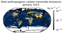
This data set contains gridded distributions of global anthropogenic and natural emissions.
Interval/period: Sat, 01/01/2000 - Thu, 12/31/2020
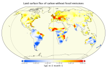
This data set contains net fluxes at the surface, atmospheric mixing ratios at model levels, and column-mean atmospheric mixing ratios for carbon dioxide (CO2), methane (CH4) and nitrous oxide (N20).
Interval/period: Mon, 01/01/1979 - Tue, 12/31/2024