Datasets

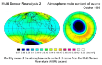
The total ozone estimates are based on solar UV radiation measurements made by ground-based spectrophotometers (Dobson or Brewer type spectrophotometers).
The vertical profiles of ozone concentration are estimated primarily using ozonesonde observations.
Data are available for 159 Dobson stations, 109 Brewer stations and 135 ozonesondes stations.
Interval/period: Tue, 01/01/1924 - Tue, 05/12/2026

Interval/period: Sun, 10/01/1978 - Mon, 09/29/2025

Interval/period: Tue, 01/01/1991 - Thu, 12/31/2020
Interval/period: Wed, 10/25/1978 - Wed, 09/24/2025

Interval/period: Mon, 01/01/1979 - Tue, 09/30/2025

Interval/period: Tue, 10/01/2002 - Sat, 04/12/2025

Interval/period: Fri, 01/01/1993 - Sun, 12/31/2023
Interval/period: Tue, 09/01/1981 - Sat, 12/31/2016

Interval/period: Mon, 01/01/1979 - Wed, 04/01/2026
Interval/period: Thu, 06/01/1995 - Thu, 07/31/2025

S2S project behind the dataset started in 2013 as a joint initiative of the World Weather Research Programme (WWRP) and the World Climate Research Programme (WCRP).
The goal of S2S project was to improve sub-seasonal forecast skill through combining multiple forecasting systems, enable multi-model evaluations and enhance knowledge sharing between operational centres.
Interval/period: Thu, 01/01/2015 - Wed, 05/06/2026

S2S project behind the dataset started in 2013 as a joint initiative of the World Weather Research Programme (WWRP) and the World Climate Research Programme (WCRP).
The goal of S2S project was to improve sub-seasonal forecast skill through combining multiple forecasting systems, enable multi-model evaluations and enhance knowledge sharing between operational centres.
Interval/period: Tue, 03/01/2011 - Tue, 06/09/2026
Interval/period: Tue, 10/01/2002 - Tue, 12/31/2024
Interval/period: Wed, 01/01/1958 - Sun, 03/01/2026
Interval/period: Wed, 01/01/1958 - Wed, 01/01/2025
Interval/period: Wed, 04/01/1970 - Tue, 07/01/2025
Interval/period: Thu, 01/01/2015 - Thu, 05/07/2026
Interval/period: Fri, 03/01/2024 - Thu, 05/07/2026
Interval/period: Wed, 01/01/2003 - Thu, 12/31/2020
Interval/period: Wed, 01/01/2003 - Thu, 12/31/2020
Interval/period: Mon, 01/01/1979 - Tue, 12/31/2024
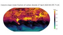
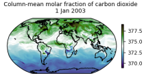
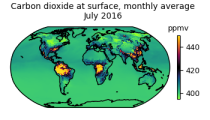
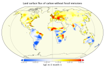
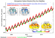
carbon dioxide
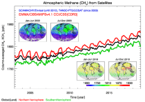
methane
tropospheric ozone
stratospheric ozone
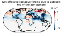
interactions between anthropogenic aerosols and radiation
interactions between anthropogenic aerosols and clouds
Interval/period: Wed, 01/01/2003 - Sun, 12/31/2017
Interval/period: Wed, 01/01/2003 - Thu, 10/31/2024
Interval/period: Wed, 01/01/2003 - Sun, 12/31/2023
Interval/period: Tue, 10/01/2002 - Tue, 12/31/2024