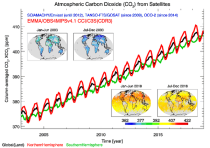
Displaying 51 - 75 of 108
This dataset provides geographical distributions of the radiative forcing (RF) by key atmospheric constituents. The radiative forcing estimates are based on the CAMS reanalysis and additional model simulations and are provided separately for...

carbon dioxide
methane
tropospheric ozone
stratospheric ozone
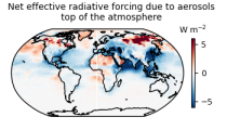
interactions between anthropogenic aerosols and radiation
interactions between anthropogenic aerosols and clouds

calendar_today Interval/period: Wed, 01/01/2003 - Sun, 12/31/2017

EAC4 (ECMWF Atmospheric Composition Reanalysis 4) is the fourth generation ECMWF global reanalysis of atmospheric composition. Reanalysis combines model data with observations from across the world into a globally complete and consistent dataset using a model of the atmosphere based on the laws of physics and chemistry.

calendar_today Interval/period: Wed, 01/01/2003 - Thu, 10/31/2024

EAC4 (ECMWF Atmospheric Composition Reanalysis 4) is the fourth generation ECMWF global reanalysis of atmospheric composition. Reanalysis combines model data with observations from across the world into a globally complete and consistent dataset using a model of the atmosphere based on the laws of physics and chemistry.

calendar_today Interval/period: Wed, 01/01/2003 - Sun, 12/31/2023

The CAMS solar radiation services provide historical values (2004 to present) of global (GHI), direct (BHI) and diffuse (DHI) solar irradiation, as well as direct normal irradiation (BNI). The aim is to fulfil the needs of European and national policy development and the requirements of both commercial and public downstream services, e.g. for planning, monitoring, efficiency improvements and the integration of solar energy systems into energy supply grids.

calendar_today Interval/period: Thu, 01/01/2004 - Thu, 05/07/2026

ERA5 is the fifth generation ECMWF reanalysis for the global climate and weather for the past 8 decades.
Data is available from 1940 onwards.
ERA5 replaces the ERA-Interim reanalysis.

calendar_today Interval/period: Mon, 01/01/1940 - Sat, 05/02/2026

ERA5 is the fifth generation ECMWF reanalysis for the global climate and weather for the past 8 decades.
Data is available from 1940 onwards.
ERA5 replaces the ERA-Interim reanalysis.

calendar_today Interval/period: Mon, 01/01/1940 - Sat, 05/02/2026

ERA5 is the fifth generation ECMWF reanalysis for the global climate and weather for the past 8 decades.
Data is available from 1940 onwards. ERA5 replaces the ERA-Interim reanalysis.

calendar_today Interval/period: Mon, 01/01/1940 - Fri, 12/06/2024

ERA5-Land is a reanalysis dataset providing a consistent view of the evolution of land variables over several decades at an enhanced resolution compared to the
Fifth Generation of the European Centre for Medium-Range Weather Forecasts (ECMWF) Reanalysis (ERA5).
Produced by replaying only the land component of the ECMWF ERA5 climate reanalysis, it benefits from the same physical data-assimilation framework but runs offline at
higher spatial detail (9 km grid) to deliver richer land-surface information.

calendar_today Interval/period: Sun, 01/01/1950 - Thu, 12/31/2026

ERA5 is the fifth generation ECMWF reanalysis for the global climate and weather for the past 8 decades.
Data is available from 1940 onwards.
ERA5 replaces the ERA-Interim reanalysis.

calendar_today Interval/period: Mon, 01/01/1940 - Wed, 04/01/2026

ERA5 is the fifth generation ECMWF reanalysis for the global climate and weather for the past 8 decades.
Data is available from 1940 onwards.
ERA5 replaces the ERA-Interim reanalysis.

calendar_today Interval/period: Mon, 01/01/1940 - Wed, 04/01/2026

ERA5 is the fifth generation ECMWF reanalysis for the global climate and weather for the past 8 decades.
Data is available from 1940 onwards.
ERA5 replaces the ERA-Interim reanalysis.

calendar_today Interval/period: Mon, 01/01/1940 - Sat, 05/02/2026

ERA5 is the fifth generation ECMWF reanalysis for the global climate and weather for the past 8 decades.
Data is available from 1940 onwards.
ERA5 replaces the ERA-Interim reanalysis.

calendar_today Interval/period: Mon, 01/01/1940 - Sat, 05/02/2026

ERA5-Land is a reanalysis dataset providing a consistent view of the evolution of land variables over several decades at an enhanced resolution compared to ERA5. ERA5-Land has been produced by replaying the land component of the ECMWF ERA5 climate reanalysis. Reanalysis combines model data with observations from across the world into a globally complete and consistent dataset using the laws of physics. Reanalysis produces data that goes several decades back in time, providing an accurate description of the climate of the past.

calendar_today Interval/period: Sun, 01/01/1950 - Sat, 05/02/2026

ERA5-Land is a reanalysis dataset providing a consistent view of the evolution of land variables over several decades at an enhanced resolution compared to ERA5. ERA5-Land has been produced by replaying the land component of the ECMWF ERA5 climate reanalysis. Reanalysis combines model data with observations from across the world into a globally complete and consistent dataset using the laws of physics. Reanalysis produces data that goes several decades back in time, providing an accurate description of the climate of the past.

calendar_today Interval/period: Sun, 01/01/1950 - Wed, 04/01/2026

ERA5-Land is a reanalysis dataset providing a consistent view of the evolution of land variables over several decades at an enhanced resolution compared to ERA5. ERA5-Land has been produced by replaying the land component of the ECMWF ERA5 climate reanalysis. Reanalysis combines model data with observations from across the world into a globally complete and consistent dataset using the laws of physics. Reanalysis produces data that goes several decades back in time, providing an accurate description of the climate of the past.

calendar_today Interval/period: Sun, 01/01/1950 - Sat, 05/02/2026

This dataset provides atmospheric CO₂ observations as derived from satellite radiances. It consists of two types of products each covering a different part of the atmosphere: (i) The average CO₂ mixing ratio of the entire atmosphere from the Earth’s surface to the top of the atmosphere. These column-averaged mixing ratio products are referred to as “XCO2” products. (ii) Mid-tropospheric (MT) CO₂ mixing ratio products. These products are referred to as "MTCO2" products. These products can be used to monitor the spatial distribution and temporal evolution of CO₂.

calendar_today Interval/period: Tue, 10/01/2002 - Tue, 12/31/2024

The dataset provides climate extreme indices related to temperature and precipitation as defined by the Expert Team on Climate Change Detection and Indices (ETCCDI), as well as selected heat stress indicators (HSI). The indices are provided for historical and future climate projections (SSP1-2.6, SSP2-4.5, SSP3-7.0, SSP5-8.5) included in the Coupled Model Intercomparison Project Phase 6 (CMIP6) and used in the 6th Assessment Report of the Intergovernmental Panel on Climate Change (IPCC).

calendar_today Interval/period: N/A

Cloud properties directly influence the state of the Earth´s upper-air atmosphere. Clouds have an effect on weather and climate through their contribution to the Earth’s water cycle and impact on the Earth’s energy budget. They impact atmospheric motions on a range of spatial and temporal scales and contribute to changes in the atmospheric composition.

calendar_today Interval/period: Mon, 01/01/1979 - Mon, 06/30/2025

This catalogue entry provides daily climate projections on pressure levels from a large number of experiments, models, members and time periods computed in the framework of fifth phase of the Coupled Model Intercomparison Project (CMIP5). The term "pressure levels" is used to express that the variables were computed at multiple vertical levels, which may differ in number and location among the different models.

calendar_today Interval/period: Sun, 01/01/1860 - Mon, 12/31/2300

This catalogue entry provides daily climate projections on single levels from a large number of experiments, models, members and time periods computed in the framework of the fifth phase of the Coupled Model Intercomparison Project (CMIP5). The term "single levels" is used to express that the variables are computed at one vertical level which can be surface (or a level close to the surface) or a dedicated pressure level in the atmosphere. Multiple vertical levels are excluded from this catalogue entry.

calendar_today Interval/period: Wed, 01/01/1800 - Fri, 12/31/2100

This catalogue entry provides monthly climate projections on pressure levels from a large number of experiments, models, members and time periods computed in the framework of the fifth phase of the Coupled Model Intercomparison Project (CMIP5). The term "pressure levels" is used to express that the variables were computed at multiple vertical levels, which may differ in number and location among the different models.

calendar_today Interval/period: Sun, 01/01/1860 - Mon, 12/31/2300

This catalogue entry provides monthly climate projections on single levels from a large number of experiments, models, members and time periods computed in the framework of fifth phase of the Coupled Model Intercomparison Project (CMIP5). The term "single levels" is used to express that the variables are computed at one vertical level which can be surface (or a level close to the surface) or a dedicated pressure level in the atmosphere. Multiple vertical levels are excluded from this catalogue entry.

calendar_today Interval/period: Sun, 01/01/1860 - Mon, 12/31/2300

This catalogue entry provides daily and monthly global climate projections data from a large number of experiments, models and time periods computed in the framework of the sixth phase of the Coupled Model Intercomparison Project (CMIP6).
CMIP6 data underpins the Intergovernmental Panel on Climate Change 6th Assessment Report. The use of these data is mostly aimed at:

addressing outstanding scientific questions that arose as part of the IPCC reporting process;
improving the understanding of the climate system;

calendar_today Interval/period: Sun, 01/01/1860 - Mon, 12/31/2300

This catalogue entry provides daily and monthly global climate model data from Decadal Climate Predictions Project (DCPP) experiments, part of the sixth phase of the Coupled Model Intercomparison Project (CMIP6). The decadal data in the Climate Data Store (CDS) are a quality-controlled subset of the full DCPP.

calendar_today Interval/period: Sun, 01/01/1860 - Mon, 12/31/2300

This dataset provides daily and monthly fields of global sea surface temperature (SST) and sea ice surface temperature (IST) from 1982 to the present, using observations from multiple infrared and passive microwave satellite sensors. SST is a key driver of global weather and climate, affecting ocean-atmosphere interactions and driving climate variability.

calendar_today Interval/period: Fri, 01/01/1982 - Tue, 12/31/2024