Displaying 726 - 750 of 887
This dataset provides surface-level particulate matter (PM2.5 and PM10) concentrations derived from in situ low-cost sensor (LCS) measurements, produced by the European Centre for Medium-Range Weather Forecasts (ECMWF) in the context of the Horizon Europe All Data for Green Deal project. This dataset differs from existing air quality datasets by combining crowdsourced observations with a robust correction framework, producing high-resolution, reference-aligned gridded products.

calendar_today Interval/period: Mon, 01/01/2018 - Tue, 12/31/2024

open_in_newview in XDS

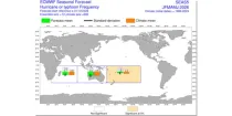
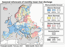
The ECMWF seasonal forecasts (SEAS5) are produced every month with a 51-member ensemble at a ...

calendar_today Interval/period: N/A

open_in_newview in Open Charts

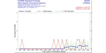
This chart provides information on the verification of forecasts of the number of tropical ...

calendar_today Interval/period: N/A

open_in_newview in Open Charts
This dataset provides water variables and indicators based on hydrological impact modelling, forced by bias adjusted regional climate simulations from the European Coordinated Regional Climate Downscaling Experiment (EURO-CORDEX). The dataset contains Essential Climate Variable (ECV) data in the form of daily mean river discharge and a set of climate impact indicators (CIIs) for both water quantity and quality.
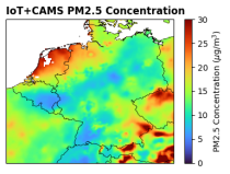
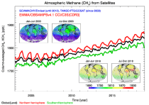
ECV datasets provide the empirical evidence needed to understand the current climate and predict future changes.

calendar_today Interval/period: N/A

This dataset provides estimates of surface elevation change over the Greenland and Antarctic ice sheets since 1992, utilizing satellite radar altimetry from five missions: ERS-1, ERS-2, ENVISAT, CryoSat-2, and Sentinel-3A. The surface elevation change is modelled over successive, overlapping periods and reported monthly.

calendar_today Interval/period: Wed, 01/01/1992 - Mon, 05/11/2026

This dataset provides annual ice velocity maps of the Greenland and Antarctic Ice Sheets derived from Sentinel-1 data. The product represents the current state-of-the-art in Europe for satellite-based ice velocity data records. It follows from the European Space Agency (ESA) Climate Change Initiative (CCI) and is guided by the Global Climate Observing System (GCOS) targets for the Ice Sheets Essential Climate Variable (ECV).

calendar_today Interval/period: Sun, 10/01/2017 - Mon, 05/11/2026

Case study with an experimental IFS EDT configuration (CY49R2). Initialized on 2024-05-27 at 00Z. Outputting votemper, vosaline, vozocrtx, vomecrty on all ocean model levels.

Examples

retrieve, class=rd, date=2024-05-27, expver=inq9, stream=oper, type=fc, levtype=sfc, param=2t, time=00:00:00, step=24, target='output.grib'

2m-temperature at step 24

calendar_today Interval/period: N/A

Some Member States also archive output other than from IFS into MARS. One example of such activity is the COSMO-LEPS forecast suite, running daily at ECMWF.

calendar_today Interval/period: N/A

These are experiments created by ECMWF Member States.

calendar_today Interval/period: N/A

This dataset provides atmospheric CH₄ observations as derived from satellite radiances. It consists of two types of products each covering a different part of the atmosphere: (i) The average CH₄ mixing ratio of the entire atmosphere from the Earth’s surface to the top of the atmosphere. These column-averaged mixing ratio products are referred to as “XCH4” products. (ii) Mid-tropospheric (MT) CH₄ mixing ratio products. These products are referred to as "MTCH4" products. These products can be used to monitor the spatial distribution and temporal evolution of CH₄.

calendar_today Interval/period: Tue, 10/01/2002 - Tue, 12/31/2024

CAMS methane forecasts

calendar_today Interval/period: N/A

open_in_newview in Open Charts

A 49R1 forecast experiment has been run to generate model fields which can be used to run an offline forward operator for polarimetric radio occultation observations. The fields include convective snow and rain, which are not a standard output for operations. The dates fit to Atmospheric River and Tropical Cyclone cases used for testing the forward operator generating simulated PRO fields (dPhi) and comparing them to observed ones.

Examples

calendar_today Interval/period: N/A

The ECMWF seasonal forecasts (SEAS5) are produced every month with a 51-member ensemble at ...

calendar_today Interval/period: N/A

open_in_newview in Open Charts
Water vapour is has been recognised as an Essential Climate Variable as it provides the basis for all cloud formation and physics and furthermore influences the Earth's heat budget due to its high absorbance of long and short-wave radiation. Total column water vapour (TCWV) is a measure of the integrated water vapour content of the atmosphere.
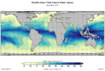
This catalogue entry provides the TCWV data product usually called Hamburg Ocean Atmosphere Parameters and Fluxes from Satellite Data (HOAPS).

calendar_today Interval/period: Wed, 05/01/2002 - Thu, 03/01/2012

ERA5–Drought is a global reconstruction of drought indices from 1940 to present.
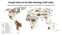
The dataset comprises two standardised drought indices:
- the Standardised Precipitation Index (SPI)
- the Standardised Precipitation-Evapotranspiration Index (SPEI).

calendar_today Interval/period: Mon, 01/01/1940 - Sun, 03/01/2026

This dataset provides meteorological and snow indicators for Europe, characterizing operating conditions of winter ski resorts under past and future climate scenarios. The dataset consists of 39 indicators of atmospheric and snow conditions computed in a similar manner for all mountain regions in Europe at the scale of NUTS-3 regions (Nomenclature of Territorial Units for Statistics) and by steps of 100 m elevation.

calendar_today Interval/period: Sun, 01/01/1950 - Fri, 01/01/2100

MUCAPE (Most Unstable Convective Available Potential Energy) is an indicator of atmospheric instability (the susceptibility of the troposphere to support free convection) and...

calendar_today Interval/period: N/A

open_in_newview in Open Charts
This dataset provides hydrological seasonal forecasts of monthly mean river discharge across Europe. Two hydrological model ensembles are provided. The first is an E-HYPE multi-model system comprising eight model realisations using a catchment-based resolution. The second comprises the E-HYPEgrid, VIC-WUR and EFAS (LISFLOOD) hydrological models at a 5km gridded resolution.

calendar_today Interval/period: Tue, 12/01/2020 - Wed, 04/01/2026

This dataset provides hydrological seasonal reforecasts of monthly mean river discharge across Europe for the period 1993 to 2016. The first is an E-HYPE multi-model system comprising eight model realisations using a catchment-based resolution. The second comprises the E-HYPEgrid, VIC-WUR and LISFLOOD-EFAS hydrological models at a 5km gridded resolution.

calendar_today Interval/period: Fri, 01/01/2021 - Mon, 05/11/2026

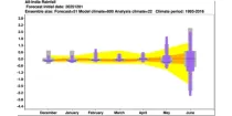
These charts aim to point towards areas where anomalous weather is likely to occur. ...

calendar_today Interval/period: N/A

open_in_newview in Open Charts

This chart shows 7-day mean anomalies for a range of parameters from the ECMWF Sub-seasonal ...

calendar_today Interval/period: N/A

open_in_newview in Open Charts
This dataset provides bias-corrected reconstruction of near-surface meteorological variables derived from the fifth generation of the European Centre for Medium-Range Weather Forecasts (ECMWF) atmospheric reanalyses (ERA5). It is intended to be used as a meteorological forcing dataset for land surface and hydrological models.

calendar_today Interval/period: Mon, 01/01/1979 - Mon, 12/31/2018

The nextGEMS data is aligned with the Climate Change Adaptation Digital Twin. The DestinE Digital Twin for Climate Change Adaptation (Climate DT) supports adaptation activities by providing innovative climate information on multi-decadal timescales, globally, at scales at which many impacts of climate change are observed.

calendar_today Interval/period: N/A

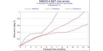
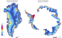
This chart provides a range of skill scores relating to forecasts of the evolution of the sea ...

calendar_today Interval/period: N/A

open_in_newview in Open Charts