Datasets

This dataset provides aerosol optical depths and aerosol-radiation radiative effects for four different aerosol origins: anthropogenic, mineral dust, marine, and land-based fine-mode natural aerosol. The latter mostly consists of biogenic aerosols.
Interval/period: N/A

carbon dioxide
methane
tropospheric ozone
stratospheric ozone
interactions between anthropogenic aerosols and radiation
interactions between anthropogenic aerosols and clouds
Interval/period: Wed, 01/01/2003 - Sun, 12/31/2017

This dataset provides geographical distributions of the radiative forcing (RF) by key atmospheric constituents. The radiative forcing estimates are based on the CAMS reanalysis and additional model simulations and are provided separately for...
- carbon dioxide
- methane
- tropospheric ozone
- stratospheric ozone
- interactions between anthropogenic aerosols and radiation
Interval/period: N/A
Interval/period: Wed, 01/01/2003 - Thu, 10/31/2024

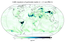
EAC4 (ECMWF Atmospheric Composition Reanalysis 4) is the fourth generation ECMWF global reanalysis of atmospheric composition. Reanalysis combines model data with observations from across the world into a globally complete and consistent dataset using a model of the atmosphere based on the laws of physics and chemistry.
Interval/period: N/A
Interval/period: Wed, 01/01/2003 - Sun, 12/31/2023

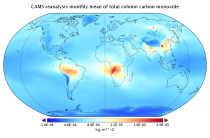
EAC4 (ECMWF Atmospheric Composition Reanalysis 4) is the fourth generation ECMWF global reanalysis of atmospheric composition. Reanalysis combines model data with observations from across the world into a globally complete and consistent dataset using a model of the atmosphere based on the laws of physics and chemistry.
Interval/period: N/A
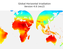
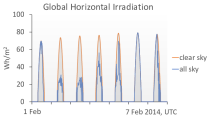
irradiation, as well as direct normal irradiation, on a latitude/longitude grid
covering land surfaces and coastal areas of Europe, Africa, Oceania, Eastern
South America, the Middle East and South-East Asia. It is created from 15 minute
resolved timeseries at each grid point. These timeseries were calculated by the
CAMS Solar Radiation Time Series Service and use information on aerosol, ozone
Interval/period: Sat, 01/01/2005 - Sun, 12/31/2023
Interval/period: Thu, 01/01/2004 - Thu, 05/07/2026

This dataset provides output from a 10-member ensemble global atmosphere simulation covering the period 1980 to 2023 produced with the European Centre for Medium-Range Weather Forecasts (ECMWF) Integrated Forecasting System (IFS), using a Tco399 L137 configuration of the IFS, which has an average horizontal grid spacings of ∼28 km. The simulation is constrained by time-evolving external climate forcings, including observed greenhouse gas and aerosol concentrations.
Interval/period: N/A
This dataset provides output from a single member global atmosphere simulation covering the period 1980 to 2023 produced with the European Centre for Medium-Range Weather Forecasts (ECMWF) Integrated Forecasting System (IFS), using a Tco399 L137 configuration of the IFS, which has an average horizontal grid spacings of ∼9 km. The simulation is constrained by time-evolving external climate forcings, including observed greenhouse gas and aerosol concentrations.
Interval/period: N/A
This dataset provides output from a 10-member ensemble global atmosphere reference simulation covering the period 1980 to 2023 produced with the European Centre for Medium-Range Weather Forecasts (ECMWF) Integrated Forecasting System (IFS), using a Tco399 L137 configuration of the IFS, which has an average horizontal grid spacings of ∼28 km.
Interval/period: N/A
This dataset provides output from a single member global atmosphere reference simulation covering the period 1980 to 2023 produced with the European Centre for Medium-Range Weather Forecasts (ECMWF) Integrated Forecasting System (IFS), using a Tco1279 L137 configuration of the IFS, which has an average horizontal grid spacings of ∼9 km.
Interval/period: N/A
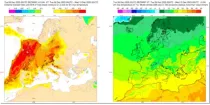
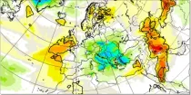
These charts show areas where anomalous 2 m maximum temperatures are likely to occur. These charts are based on the ECMWF ensem ...
Interval/period: N/A
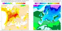
These charts show areas where anomalous 2 m minimum temperatures are likely to occur. These charts are based on the ECMWF ensem ...
Interval/period: N/A
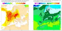
These charts show areas where anomalous 2 m temperatures are likely to occur. These charts are based on the ECMWF ensemble forecas ...
Interval/period: N/A

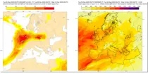
These charts show areas where anomalous CAPE are likely to occur.
Interval/period: N/A

These charts show areas where anomalous CAPE Shear are likely to occur.
Interval/period: N/A
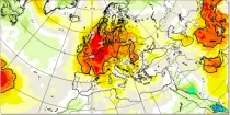
This chart aims to highlight areas where unusually anomalous 2 metre temperatures are ...
Interval/period: N/A

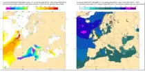
These charts aim to provide pointers to areas where anomalous precipitation amounts are likely to occur during the 24 hour, 2 day, 5 day or 10 day period previous to the selected validity time...
Interval/period: N/A
This chart aims to highlight areas where unusually anomalous precipitation is likely to ...
Interval/period: N/A
These charts show areas where anomalous significant wave heights are likely to occur. These charts are based on the ECMWF ense ...
Interval/period: N/A
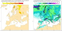
These charts show areas where anomalous snow fall is likely to occur. These charts are based on the ECMWF ensemble for ...
Interval/period: N/A
These charts aim to provide pointers to areas where anomalous values of water vapour flux are likely to occur based on the ECMWF en ...
Interval/period: N/A