Datasets

A subset of ECMWF real-time forecast data from the IFS and AIFS models is made available to the public free of charge. Their use is governed by the Creative Commons CC-BY-4.0 licence and the ECMWF Terms of Use.
Interval/period: N/A
15-member coupled IFS (cycle 43R1) extended-range reforecast experiment covering the period 1989-2015. The atmosphere is configured with 91 vertical levels and uses the Tco399 cubic octahedral reduced Gaussian grid. The IFS is coupled hourly to the 75 level version of the NEMO v3.4 ocean model and the LIM2 sea-ice model, both of which use the ORCA025 tripolar grid. Coupling follows the implementation used in ECMWF operational forecasts.
Interval/period: N/A
15-member coupled IFS (cycle 43R1) extended-range reforecast experiment covering the period 1989-2015 with bias-corrected sea-surface temperatures (SSTs) in the North Atlantic region. This experiment can be compared with gkzp, which is the relevant control without bias-correction. The atmosphere is configured with 91 vertical levels and uses the Tco399 cubic octahedral reduced Gaussian grid.
Interval/period: N/A
Interval/period: Wed, 01/03/1940 - Tue, 05/05/2026
The AI Weather Quest (AI WQ), organised by ECMWF, is an ambitious international competition designed to harness artificial intelligence (AI) and machine learning (ML) in advancing weather forecasting.
Interval/period: N/A
WMO Core, previously known as WMO Essential, is available to the public and governed by the Creative Commons CC-4.0-BY licence and also ECMWF Terms of Use.
Interval/period: N/A
WMO Recommended, previously known as WMO Additional, is available to the public and governed by the Creative Commons CC-4.0-BY licence and also ECMWF Terms Of Use.
Interval/period: N/A

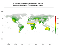
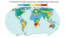
River discharge
Volumetric soil moisture
Snow water equivalent
Soil wetness index (root zone)
Runoff water equivalent (surface plus subsurface)
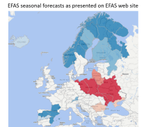
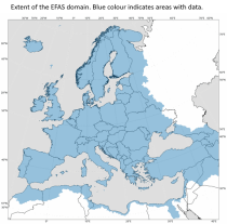
Interval/period: Thu, 10/11/2018 - Mon, 04/06/2026
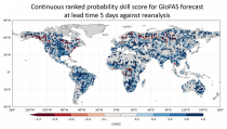
River discharge
Soil wetness index (root zone)
Snow water equivalent
Runoff water equivalent (surface plus subsurface)
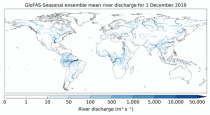
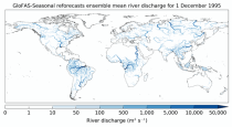
Interval/period: Tue, 11/05/2019 - Thu, 05/07/2026

River discharge
Volumetric soil moisture
Snow water equivalent
Soil wetness index (root zone)
Runoff water equivalent (surface plus subsurface)
Interval/period: Tue, 01/01/1991 - Tue, 05/05/2026
River discharge
Soil wetness index (root zone)
Snow water equivalent
Runoff water equivalent (surface plus subsurface)
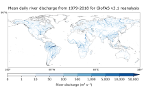
Interval/period: Mon, 01/01/1979 - Tue, 05/05/2026

River discharge
Volumetric soil moisture
Snow water equivalent
Soil wetness index (root zone)
Runoff water equivalent (surface plus subsurface)
Interval/period: Wed, 10/14/2020 - Fri, 05/08/2026

Interval/period: Sun, 01/03/1999 - Sat, 11/25/2023
The DestinE Digital Twin for Climate Change Adaptation (Climate DT) supports adaptation activities through the provision of innovative climate information on multi-decadal timescales, at scales at which the impacts of climate change are observed.
Interval/period: N/A
The DestinE Digital Twin for Weather-Induced Extremes (Extremes DT) supports rapid decision-making in response to meteorological, hydrological and air quality extremes.
Interval/period: N/A
An eddy-permitting ocean reanalysis spanning the period 1979–2012. Includes increased horizontal and vertical resolution, an prognostic sea-ice component, new versions of the ocean and data assimilation system, revised surface fluxes, new version and treatment of satellite sea surface height data, and assimilation of sea-ice concentration, among others.
Interval/period: N/A
Uses a sophisticated data assimilation methodology which includes a model bias correction. The ocean model used is forced by atmospheric daily surface fluxes, relaxed to SST and bias corrected.
Interval/period: N/A
The ECMWF OCEAN5 system is a new global eddy-permitting ocean-sea ice ensemble reanalysis analysis system. This Technical Memorandum gives a full description of the OCEAN5 system, with the focus on its Behind-Real-Time (BRT) component, the reanalysis product ORAS5. The OCEAN5 Real-Time (RT) component includes all upgrades developed for ORAS5 and runs daily using the latest observations and forcing fields from the operational Numerical Weather Prediction (NWP).
Interval/period: N/A
Interval/period: Sun, 02/01/1981 - Wed, 04/01/2026
River discharge
Volumetric soil moisture
Snow water equivalent
Soil wetness index (root zone)
Runoff water equivalent (surface plus subsurface)
Interval/period: Sun, 11/01/2020 - Wed, 04/01/2026
River discharge
Soil wetness index (root zone)
Snow water equivalent
Runoff water equivalent (surface plus subsurface)
Interval/period: Tue, 12/01/2020 - Wed, 04/01/2026
River discharge
Volumetric soil moisture
Snow water equivalent
Soil wetness index (root zone)
Runoff water equivalent (surface plus subsurface)
Interval/period: Fri, 01/01/1999 - Fri, 05/08/2026
Interval/period: Thu, 01/01/1981 - Sat, 07/01/2023