

El Niño conditions in the central Pacific remain very strong, and sea-surface temperatures are now close to their expected maximum value as the event moves towards its peak at the end of the year.
Substantial El Niño events can have strong repercussions on global weather patterns, although specific impacts may vary. For example, this year parts of Ethiopia are experiencing drought conditions, while other parts of the Horn of Africa region have been hit by tropical cyclones.
An El Niño event is a prolonged period of abnormally high sea-surface temperatures (SST) in the tropical Pacific Ocean that usually peaks at the end of the year.
Recent observations
Relative to the 1981–2010 average, the sea-surface temperature anomaly in the NINO3.4 region has increased further from the already very high September values, with the October anomaly exceeding 2.4 °C.
This is in line with forecasts, and it is the second warmest October value on record, just behind that of the 1997–1998 event.
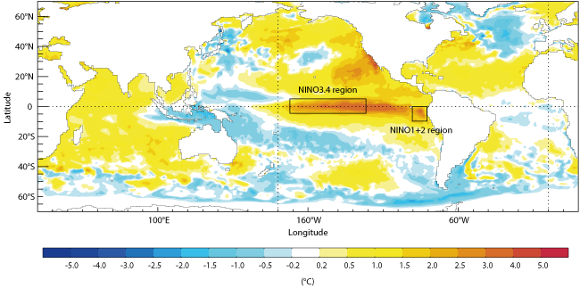
Average sea-surface temperature anomalies in October 2015. The chart shows SST anomalies compared to the 1981–2009 average.
Looking at the absolute SST in NINO3.4, temperatures have recently moved up to around 29.5 °C following a westerly wind burst.
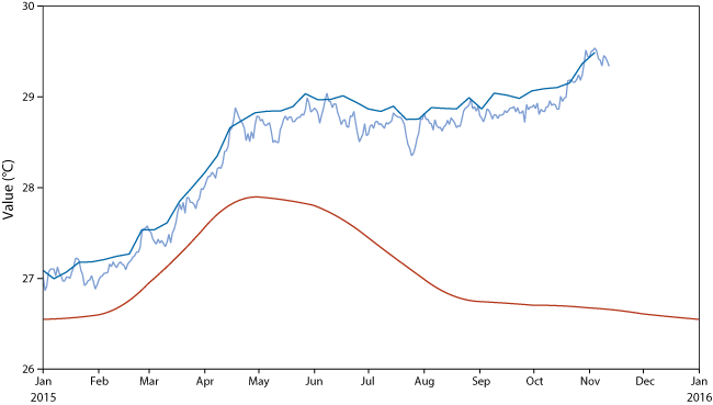
Average and observed sea-surface temperatures in NINO 3.4. The chart shows the average evolution of sea-surface temperatures in the NINO3.4 region based on the years 1981 to 2010 (red line) and the observed evolution since January 2015 according to two different analyses (dark and light blue lines).The difference between the red and blue lines is the sea-surface temperature anomaly.
In the far eastern Pacific (NINO1+2), anomalies continue to be quite large, but much smaller than in 1997.
Ethiopian drought
Substantial El Niño events contribute to many climate anomalies around the world, including changes in rainfall patterns in the Horn of Africa, but the specifics of the anomalies can differ from event to event.
This year parts of Ethiopia have been suffering from drought conditions since the summer. Seasonal forecasts from May 2015 anticipated the lack of rainfall, which is often seen during El Niño years, both in the real world and in model forecasts of past events.
At the same time, model forecasts for the last few months have suggested that more than average rainfall is likely in coastal regions of the Horn of Africa. They have also predicted an increased risk of tropical cyclones, which are generally rare in the area. Two such cyclones have hit the region recently.
Although broad patterns and risk factors can be seen in the forecasts, detailed predictions of rainfall anomalies and their impact on drought conditions remain a challenge.
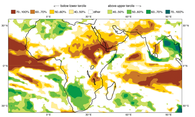
ECMWF forecast of rainfall over Africa in July–August–September 2015. The chart shows the predicted probability of July to September 2015 falling in the driest third of July-to-September periods generally (brown colours) and in the wettest third of such periods generally (green colours) as predicted by the ECMWF model from 1 May. July to September is the main rainy season for Ethiopia.
Latest forecasts
The latest forecasts suggest that SST anomalies in the central Pacific are now close to their peak, which is expected to occur around December.
The amplitude of the SST anomalies on the latest forecast plumes is now considered to be reliable. However, there remains considerable uncertainty over whether the eventual peak value of the anomaly will be just above or just below that seen in 1997.
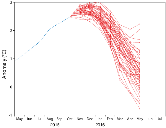
ECMWF plume of NINO3.4 sea-surface temperature anomalies. The chart shows an ensemble of predicted SST anomalies over the NINO3.4 region produced on 1 November from the ECMWF model. Ensemble forecasts account for the uncertainties inherent in the prediction of weather and ocean parameters by producing a set of possible outcomes.
In late October there was yet another very large westerly wind burst over the equatorial Pacific Ocean, which has helped drive the latest increase in NINO3.4 SST. This burst has now ended, and our medium-range and extended-range forecasts suggest the winds are likely to remain more easterly for the next few weeks, compared to typical peak El Niño conditions.
As usual, the exact evolution of SST will depend on the details of the wind variability, which is why our forecast ensemble covers a range of possible values. The seasonal forecasts do continue to suggest that the amplitude of El Niño may decline fairly rapidly in the early part of 2016.
Forecasts for the NINO1+2 region suggest that, although anomalies are likely to remain moderately large in the coming months, most likely in the range of 1–2 °C, they are expected to be well below the exceptionally high values (exceeding 4 °C) seen in 1997.
Consequently this El Niño event remains more central-Pacific-focussed than that of 1997. However, it can be seen that a few ensemble members suggest a small probability of renewed growth of NINO1+2 temperature anomalies in 2016.
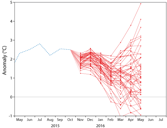
ECMWF plume of NINO1+2 sea-surface temperature anomalies. The chart shows the predicted sea-surface temperature anomalies over the NINO1+2 region produced on 1 November from the ECMWF model.