
The ocean surface is where weather meets the marine environment.
Sea-surface temperature and currents influence the atmosphere above, winds generate waves, and sea ice controls exchanges of heat and moisture. Forecasting these components together is important for weather prediction, marine operations and coastal safety.
Our work, described in a preprint available on arXiv, opens exciting opportunities for more integrated, data-driven Earth system modelling. We extend ECMWF’s Artificial Intelligence Forecasting System (AIFS) to jointly forecast the atmosphere, ocean waves, sea ice and key surface-ocean fields.
The resulting prototype, AIFS Marine, learns physically consistent relationships between atmospheric and marine components within a single forecasting model.
Figure 1 illustrates this capability for Hurricanes Idalia and Franklin, showing the atmospheric and marine responses forecast by AIFS Marine alongside those from ECMWF’s physics-based Integrated Forecasting System (IFS).
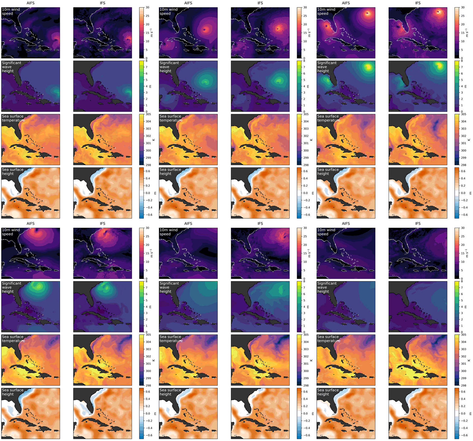
Figure 1: Comparison of AIFS Marine forecasts and forecasts from ECMWF’s physics-based Integrated Forecasting System (IFS) for Hurricanes Idalia and Franklin, initialised on 26 August 2023. Near-surface winds (top), wave height (second panel), sea-surface temperature (third panel) and sea-surface height (bottom) show aligned atmospheric and marine responses in both systems.
One model across the atmosphere–ocean interface
Traditional Earth system forecasting uses specialised models for the atmosphere, ocean, waves and sea ice, with selected information exchanged through explicit coupling mechanisms. AIFS Marine explores a complementary approach in which all atmospheric and marine fields are predicted within a single model. In this component-agnostic framework, cross-component correlations and representations are learned intrinsically from the data.
The model design and forecasting approach align closely with AIFS Single. Like AIFS Single, AIFS Marine is developed using Anemoi, the collaborative open-source framework co-developed by ECMWF and Member States to facilitate the development, training, and deployment of ML forecasting models.
The main change is the expanded Earth-system state used for training and prediction. This allows the model to learn, for example, that strong surface winds generate larger waves, that waves are attenuated at the the sea-ice edge, and that tropical cyclones can cool the sea surface through wind-driven mixing.
We trained several configurations to distinguish the effects of adding waves, the surface ocean and sea ice, or all marine components together. Waves and land are already represented alongside the atmosphere in operational AIFS v2. This work examines the marine system in greater detail, extending it to the ocean surface and sea ice.
Representing waves, sea ice and the surface ocean
AIFS Marine expands the model state with a compact set of variables representing the surface ocean and sea ice. These include sea-surface temperature, salinity and height, surface currents, and key properties of the sea-ice state, such as its concentration, volume and velocity. Wave variables – including significant wave height, mean period and direction – are represented alongside them.
Training combines ERA5 atmospheric data, a dedicated wave hindcast and the ORAS6 ocean reanalysis dataset. These datasets provide a broadly consistent description of conditions across the atmosphere–ocean interface.
Some model adaptations were needed to account for marine fields that are undefined over land, that are constrained to physical ranges or that evolve on slower timescales than atmospheric variables. Preprocessing and loss weighting were adjusted accordingly to balance learning across the different components.
Around one day of additional marine forecast skill
AIFS Marine produces skilful forecasts for almost all evaluated marine variables. At medium-range lead times, its accuracy typically corresponds to gaining roughly one forecast day compared with ECMWF’s physics-based systems under a deterministic forecast framing.
Significant wave-height errors are reduced by about 10% against satellite observations (Figure 2). Sea-ice-edge forecasts improve in both hemispheres, particularly in the Southern Ocean, while explicitly representing sea ice improves wave forecasts near the ice edge. Sea-surface temperature forecasts also show systematic improvements.
Sea-surface height is the main exception: the machine-learning (ML) model develops a negative bias with lead time, possibly because of the long-term sea-level-rise signal in the training data. This will be addressed in future development.
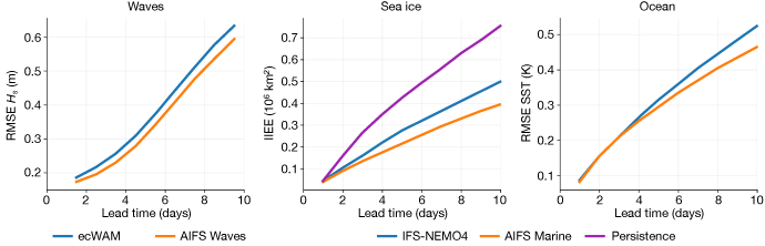
Figure 2: Forecast performance of the proposed joint model in comparison to the physics-based baselines. Left: significant wave height root mean square error (RMSE HS) against satellite altimeter observations for May–August 2024, comparing the physics-based wave model, ecWAM, with AIFS Waves. Middle: sea-ice edge position (Integrated Ice Edge Error (IIEE), verified against ocean and sea-ice reanalysis ORAS6 for 15 June–15 December 2023). Right: northern hemisphere sea-surface temperature (RMSE against reference analysis for 15 June–15 December 2023). Together, the results show a broad medium-range improvement across marine variables.
Learning physically consistent coupled behaviour
Aggregate scores tell only part of the story. A useful joint model must also respond coherently when several Earth-system components interact.
Case studies of Hurricanes Idalia and Franklin show that regions of strong wind coincide with enhanced wave activity. The storms leave cold wakes in sea-surface temperature as winds mix colder subsurface water upwards, while changes in sea-surface height and coastal wave conditions are consistent with the expected storm response.
We also tested the models far outside the conditions encountered during training. In one experiment, isolated long-period swells were inserted into an otherwise calm ocean. The model propagated the swell across ocean basins and generated new wind-driven wave systems in physically plausible ways.
In another experiment, all sea ice was removed from the initial state (Figure 3). Ice did not simply reappear from hidden memory: it returned gradually and in the seasonally appropriate hemisphere, with ice extent recovering faster than ice volume, as expected physically.
These stress tests do not prove that every forecast will be physically correct. They do, however, show that key relationships emerge from the learned dynamics rather than being copied from the initial conditions. This type of evaluation is important for building trust in ML forecasting systems, particularly as the climate moves beyond conditions well represented in historical training data.
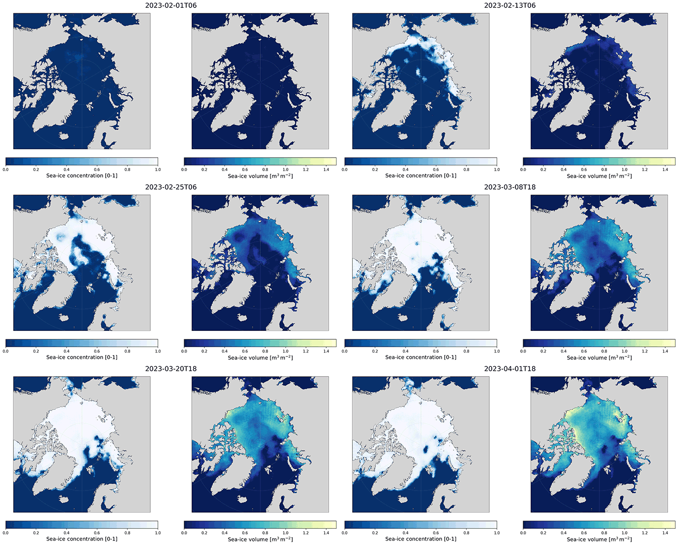
Figure 3: Arctic sea-ice recovery from 1 February 2023 after removing ice from the initial conditions. Regrowth follows the seasonal cycle, and ice volume (right) recovers more slowly than extent (left).
What changes for atmospheric forecasts?
Adding marine components leaves large-scale atmospheric forecast skill broadly unchanged. Explicit sea ice improves near-surface temperatures around the ice edge, and the evolving ocean benefits tropical temperature forecasts, while small degradations in near-surface wind scores underline the need for coherent datasets and balanced training across components.
Towards integrated Earth-system forecasting
This work shows that a single ML model can forecast the atmosphere, waves, sea ice and the surface ocean together, despite the different spatial and temporal scales on which these components evolve.
For nearly all evaluated marine variables, the joint model provides roughly one additional day of medium-range forecast skill compared with physics-based systems. It also learns physically meaningful correlations and representations across the atmosphere–ocean interface without requiring explicitly prescribed coupling mechanisms.
Ocean waves are already included in the operational AIFS v2 together with a representation of the land component. Building on this foundation, the surface ocean and sea ice are the next components we aim to bring into the AIFS.
Further development will focus on improving the consistency of atmosphere and ocean training datasets, addressing the sea-surface-height bias, and moving towards probabilistic forecasts that explicitly represent uncertainty. At longer forecast ranges, representing the deeper ocean will also become increasingly important because of its longer memory.
Joint modelling is one route towards data-driven Earth-system forecasting. In parallel, ECMWF is developing component-wise ML models within the European Commission’s Destination Earth (DestinE) initiative. These models can be trained separately and coupled modularly. Exploring both approaches will help us understand which is best suited to different forecasting needs and how they can complement each other in future operational systems.
You can read our arXiv paper in full (jointly led by Sara Hahner and Lorenzo Zampieri with equal contributions)
Top banner image: © Eisenlohr / iStock / Getty Images Plus