
Tropical cyclones (TCs) are among the most destructive weather systems. Improving forecasts of their track and intensity is critical for helping communities to prepare for severe winds, storm surge and flooding.
Forecasting TCs has been one of the more demanding tests for machine-learning weather models.
Artificial intelligence (AI) weather models have made remarkable progress in predicting the tracks of TCs. However, forecasting their intensity poses a much greater challenge, with models exhibiting a persistent tendency to underestimate storm strength. Much of this difficulty stems from the need to accurately represent the compact, often rapidly evolving inner core, where small-scale processes can strongly influence storm evolution and trigger rapid intensification.
A new collaboration with Anna Allen, Wessel Bruinsma and Richard Turner at the University of Cambridge explores a simple way to address this problem. Rather than building a new TC forecasting model from scratch, the approach starts with the existing Artificial Intelligence Forecasting System (AIFS) forecast and learns how to correct its intensity errors.
The result is a system that, when tested on TCs from the 2025 season that were not used in training, achieves performance comparable to both leading operational guidance and AI state-of-the-art systems in forecasting maximum wind speed and minimum central pressure.
Correcting the intensity weakness rather than rebuilding the model
The approach, called AIFS-TC, is based on a straightforward idea.
The AIFS forecast provides an initial estimate of a storm's future intensity. A second machine-learning system then learns the errors that AIFS tends to make and predicts a correction to that forecast.
The correction uses information already contained in the AIFS forecast. This includes the predicted track and intensity of the storm, as well as three-dimensional atmospheric fields such as wind, temperature, geopotential and humidity in a region around the cyclone. The correction is then applied to the original AIFS intensity forecast.
This is particularly useful because the underlying problem is clear. At around 0.25° resolution, the AIFS grid is too coarse to fully resolve the inner core of a TC, and the deterministic training methods further prevent AIFS from skilful TC intensity predictions. The resulting forecast tends to smooth the strongest winds and underestimate the most intense storms.
In the 2025 evaluation, the uncorrected AIFS forecast had a global wind-speed bias of almost –29 knots. After applying the correction, the global wind-speed bias was reduced to about –2 knots.
A small correction with a large effect
The correction itself combines two relatively simple machine-learning approaches.
One component uses gradient-boosted decision trees to work with a set of derived predictors from the AIFS forecast. The other uses a convolutional neural network to analyse storm-centred atmospheric fields. Their predictions can be combined to produce the final correction to the AIFS forecast.
The system is trained using TCs from 2016 to 2024, with 2025 held back as a completely unseen test year. Rapid intensification cases are given additional weight during training, reflecting the particular importance and difficulty of these events.
The approach is deliberately modest. It does not replace the global AI weather model, and it does not require a new model trained specifically from the beginning to forecast TCs. Instead, it uses the global forecast as an anchor and learns how to improve one of its known weaknesses. Having a bespoke correction mode also allows for independent and parallel developments.
Performance at the operational frontier
On the 2025 test data, the correction reduced the AIFS intensity error by roughly a factor of three.
For maximum wind speed, AIFS-TC achieved a global mean absolute error of around 11 knots, statistically indistinguishable from Google's FNV3 TC AI forecasting model. In the North Atlantic and East Pacific, where comparisons could also be made with official forecasts from the US National Hurricane Center, the three systems performed similarly.
The results are particularly interesting for rapid intensification.
Rapid intensification is conventionally defined as an increase of at least 30 knots in maximum wind speed within 24 hours. These events are among the most difficult to predict and can leave communities with relatively little time to prepare.
The raw AIFS forecast performed poorly for these cases, with an intensity error of around 70 knots. The correction reduced this to approximately 23 knots, comparable to leading AI forecasts and approaching the performance of official guidance produced by human forecasters in the regions where the comparison was made.
The correction does not eliminate the challenge. All systems continue to underestimate the peak intensity of some rapidly intensifying storms. Predicting precisely when the most extreme strengthening will occur remains difficult. But the results show that a relatively simple correction can substantially reduce a major systematic weakness in a global AI forecast.
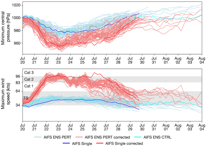
Example of the prototype tropical cyclone correction in action for Hurricane Fausto in the East Pacific, providing corrections to both AIFS Single and AIFS Ensemble (ENS) forecasts from 20 July 2026 00 UTC. The ensemble forecast includes a control forecast (CTRL) and perturbed ensemble members (PERT). Upper panel shows the predictions for minimum central pressure. Lower panel shows maximum wind speed and includes reference bands showing tropical storm (TS) and Category 1 –3 hurricane intensity thresholds.
What comes next?
The first version of AIFS-TC is based on a single deterministic AIFS-Single forecast. Training and applying the correction to the AIFS-ENS will provide a natural way to represent uncertainty in TC intensity forecasts.
The system also does not directly use observations such as satellite imagery, ocean heat content or satellite-based measurements of winds, known as scatterometer winds. These data sources are already known to contain information relevant to TC intensity, and incorporating them could help with the most difficult cases.
The next steps are to implement this work as a real-time system, stress test its performance, and evaluate it in collaboration with specialised forecasters in ECMWF Member States, for example Météo-France. Work is already underway to achieve these next steps and we look forward to sharing more with you soon.
Read more about this work here.
Top banner image: © Trifonov_Evgeniy / iStock / Getty Images Plus