Datasets

The DestinE Digital Twin for Climate Change Adaptation (Climate DT) supports adaptation activities by providing innovative climate information on multi-decadal timescales, globally, at scales at which many impacts of climate change are observed. It combines cutting-edge global Earth-system models, impact-sector applications and observations into a unified framework to provide global climate projections and impact-sector information on multi-decadal timescales (1990 to ~2050), at very high spatial resolutions (5 to 10 km).
Interval/period: N/A

Interval/period: Sat, 09/01/1984 - Thu, 07/31/2025

Interval/period: Sun, 01/01/1950 - Wed, 12/01/2100

Interval/period: Sat, 01/01/1949 - Sun, 07/05/2026
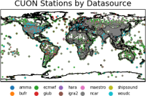
to contain all available observations from balloons ascents through the atmosphere.
The main geophysical variables are temperature, humidity, and wind speed and wind direction,
as functions of atmospheric pressure levels. The observation platforms include pilot balloons, radiosondes, and ozonesondes.
The main observation data sources are:
- the NOAA Integrated Global Radiosonde Archive (IGRA version 2),
- the NCAR Upper-Air Database (UADB), and
Interval/period: Tue, 01/01/1901 - Tue, 12/31/2024

Coupled subsesaonal reforecasts (ENS-C) consisting of 10 perturbed members, each integrated for 46-days, starting on the first of each month between 2006 and 2023 for a total of 216 start dates. The atmospheric model is configured to use the cubic octahedral reduced Gaussian grid with 137 vertical levels and a horizontal resolution of Tco319. The atmosphere is coupled hourly to an eddy-permitting NEMO4-SI3 configuration, which uses 75 vertical levels in the ocean and the eORCA025 grid.
Interval/period: N/A
Standalone ECMWF wave model CY46R1 forced by ERA5 hourly neutral 10m winds, surface air density, gustiness and sea ice fraction from 2010 to 2018. Native grid resolution is 14km, 36 directions, 36 frequencies. No wave data assimilation. Hourly output.
Examples
Interval/period: N/A
Standalone ECMWF wave model CY46R1 forced by ERA5 hourly neutral 10m winds, surface air density, gustiness and sea ice fraction from 2019 to 2020. Native grid resolution is 14km, 36 directions,36 frequencies. No wave data assimilation. Hourly output.
Examples
Interval/period: N/A
Standalone wave model CY47R1 forced by ERA5 hourly neutral 10m winds, air density, gustiness and sea ice fraction (1979-1989). Native grid is Tco639 (18km), 36 directions, 36 frequencies. No wave data assimilation. Hourly output, many parameters.
Examples
Interval/period: N/A
Standalone wave model CY47R1 forced by ERA5 hourly neutral 10m winds, air density, gustiness and sea ice fraction (1999-1999). Native grid is Tco639 (18km), 36 directions, 36 frequencies. No wave data assimilation. Hourly output, many parameters.
Examples
Interval/period: N/A
Standalone wave model CY47R1 forced by ERA5 hourly neutral 10m winds, air density, gustiness and sea ice fraction (2000-2009). Native grid is Tco639 (18km), 36 directions, 36 frequencies. No wave data assimilation. Hourly output, many parameters.
Examples
Interval/period: N/A
Standalone wave model CY47R1 forced by ERA5 hourly neutral 10m winds, air density, gustiness and sea ice fraction (2010-2020). Native grid is Tco639 (18km), 36 directions, 36 frequencies. No wave data assimilation. Hourly output, many parameters.
Examples
Interval/period: N/A
Standalone wave model CY47R3 forced by ERA5 hourly neutral 10m winds, air density, gustiness and sea ice fraction (2015-2021). Native grid is Tco639 (18km), 36 directions, 36 frequencies. No wave data assimilation. Hourly output, many parameters.
Examples
Interval/period: N/A
Standalone ecWAM wave model CY50R1 forced by corrected ERA5 hourly neutral 10m winds, air density, gustiness and sea ice fraction (1980-1989). Native grid is Tco799 (14km), 36 directions, 36 frequencies. See Bidlot et al. 2026: Wave Hindcast for ERA6 Preparation and Training Data Driven Models. ECMWF Tech Memo, in preparation, Hourly output, many parameters.
Interval/period: N/A
Standalone ecWAM wave model CY50R1 forced by corrected ERA5 hourly neutral 10m winds, air density, gustiness and sea ice fraction (1990-1999). Native grid is Tco799 (14km), 36 directions, 36 frequencies. Altimeter wave data assimilation,See Bidlot et al. 2026: Wave Hindcast for ERA6 Preparation and Training Data Driven Models. ECMWF Tech Memo, in preparation, Hourly output, many parameters.
Interval/period: N/A
Standalone ecWAM wave model CY50R1 forced by corrected ERA5 hourly neutral 10m winds, air density, gustiness and sea ice fraction (2000-2018). Native grid is Tco799 (14km), 36 directions, 36 frequencies. Altimeter wave data assimilation,See Bidlot et al. 2026: Wave Hindcast for ERA6 Preparation and Training Data Driven Models. ECMWF Tech Memo, in preparation, Hourly output, many parameters.
Interval/period: N/A
Standalone ecWAM wave model CY50R1 forced by corrected ERA5 hourly neutral 10m winds, air density, gustiness and sea ice fraction (2019-2023). Native grid is Tco799 (14km), 36 directions, 36 frequencies. Altimeter wave data assimilation,See Bidlot et al. 2026: Wave Hindcast for ERA6 Preparation and Training Data Driven Models. ECMWF Tech Memo, in preparation, Hourly output, many parameters.
Interval/period: N/A
Standalone ecWAM wave model CY50R1 forced by corrected ERA5 hourly neutral 10m winds, air density, gustiness and sea ice fraction (2024-2025). Native grid is Tco799 (14km), 36 directions, 36 frequencies. Altimeter wave data assimilation,See Bidlot et al. 2026: Wave Hindcast for ERA6 Preparation and Training Data Driven Models. ECMWF Tech Memo, in preparation, Hourly output, many parameters.
Interval/period: N/A
Note: This Generation 1 Collection has been superseded by Generation 2 Simulation-level Collections
Interval/period: N/A
The DestinE Digital Twin for Climate Change Adaptation (Climate DT) supports adaptation activities by providing innovative climate information on multi-decadal timescales, globally, at scales at which many impacts of climate change are observed. It combines cutting-edge global Earth-system models, impact-sector applications and observations into a unified framework to provide global climate projections and impact-sector information on multi-decadal timescales (1990 to ~2050), at very high spatial resolutions (5 to 10 km).
Interval/period: N/A