Datasets
Data is available from 1940 onwards.
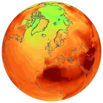
ERA5 replaces the ERA-Interim reanalysis.
Interval/period: Mon, 01/01/1940 - Sat, 05/02/2026
Data is available from 1940 onwards.
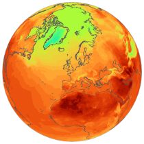
ERA5 replaces the ERA-Interim reanalysis.
Interval/period: Mon, 01/01/1940 - Sat, 05/02/2026
Interval/period: Mon, 01/01/1979 - Mon, 06/30/2025

Interval/period: Sun, 01/01/1860 - Mon, 12/31/2300

Interval/period: Wed, 01/01/1800 - Fri, 12/31/2100

Interval/period: Sun, 01/01/1860 - Mon, 12/31/2300

Interval/period: Sun, 01/01/1860 - Mon, 12/31/2300

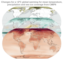
CMIP6 data underpins the Intergovernmental Panel on Climate Change 6th Assessment Report. The use of these data is mostly aimed at:
addressing outstanding scientific questions that arose as part of the IPCC reporting process;
improving the understanding of the climate system;
Interval/period: Sun, 01/01/1860 - Mon, 12/31/2300

Interval/period: Sun, 01/01/1860 - Mon, 12/31/2300

Interval/period: Sat, 01/01/1949 - Tue, 05/12/2026
Interval/period: Thu, 10/18/2018 - Wed, 07/31/2019
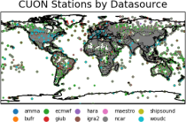
to contain all available observations from balloons ascents through the atmosphere.
The main geophysical variables are temperature, humidity, and wind speed and wind direction,
as functions of atmospheric pressure levels. The observation platforms include pilot balloons, radiosondes, and ozonesondes.
The main observation data sources are:
- the NOAA Integrated Global Radiosonde Archive (IGRA version 2),
- the NCAR Upper-Air Database (UADB), and
Interval/period: Tue, 01/01/1901 - Tue, 12/31/2024
The dataset is organised around two main variables:
the mean radiant temperature (MRT)
the universal thermal climate index (UTCI)
Interval/period: Fri, 12/01/1939 - Sat, 05/02/2026
Interval/period: Mon, 01/01/1940 - Fri, 05/09/2025
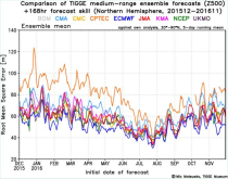
The dataset has been available since October 2006. TIGGE was established as a key component of THORPEX: a World Weather Research Programme to accelerate the improvements in the accuracy of 1-day to 2 week high-impact weather forecasts (THORPEX stands for THe Observing system Research and Predictability EXperiment)
Interval/period: Sun, 10/01/2006 - Wed, 05/06/2026

Interval/period: Sun, 01/01/1950 - Fri, 12/31/2100
Interval/period: Mon, 01/01/1979 - Sun, 02/01/2026
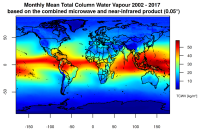
This catalogue entry presents two extensive, high-quality observational datasets of TCWV, specifically tailored for climate analysis and applications.
Interval/period: Tue, 01/01/2002 - Sun, 12/31/2017
Interval/period: Sun, 01/01/1860 - Mon, 12/31/2300
Interval/period: Sun, 01/01/1860 - Mon, 12/31/2300

Interval/period: Sun, 01/01/2017 - Fri, 05/01/2026

Interval/period: Sun, 01/01/2017 - Fri, 05/01/2026

Interval/period: Thu, 01/01/1981 - Fri, 05/01/2026

Interval/period: Thu, 01/01/1981 - Fri, 05/01/2026
Interval/period: Thu, 01/01/1981 - Fri, 05/01/2026