Datasets
Displaying 51 - 59 of 59
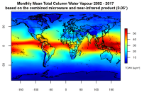
Atmospheric water vapor, quantified here as Total Column Water Vapor (TCWV), holds paramount importance in monitoring and understanding Earth's climate dynamics. Its role as an Essential Climate Variable is pivotal, serving as the foundation for cloud formation, cloud physics, and significantly impacting the Earth's heat budget through its proficient absorption of both long and short-wave radiation.
This catalogue entry presents two extensive, high-quality observational datasets of TCWV, specifically tailored for climate analysis and applications.
This catalogue entry presents two extensive, high-quality observational datasets of TCWV, specifically tailored for climate analysis and applications.
Interval/period: Tue, 01/01/2002 - Sun, 12/31/2017
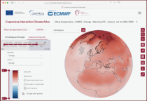
This catalogue entry provides the gridded climate data (monthly/annual timeseries) used for the Copernicus Climate Change Service Atlas (C3S Atlas). The gridded datasets consist of in-situ and satellite observation-based datasets, reanalyses (CERRA, ERA5, ERA5-Land, and ORAS5) and global (CMIP5 and CMIP6) and regional (CORDEX) climate projections for the variables and indices included in the C3S Atlas.
Interval/period: Sun, 01/01/1860 - Mon, 12/31/2300
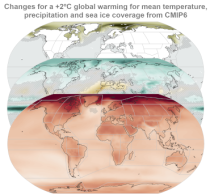
This catalogue entry provides gridded data from global (CMIP5 and CMIP6) and regional (CORDEX) projections for the set of 22 variables and indices included in the IPCC Interactive Atlas, a novel contribution from Working Group I (WGI) to the IPCC Sixth Assessment Report (AR6). These variables and indices are relevant for the climatic impact-drivers used in the regional assessments conducted in AR6 (Chapters 10, 11, 12 and Atlas), related to heat and cold, wet and dry, snow and ice, and wind.
Interval/period: Sun, 01/01/1860 - Mon, 12/31/2300

This entry covers pressure-level data post-processed for bias adjustment on a monthly time resolution.
Interval/period: Sun, 01/01/2017 - Fri, 05/01/2026

This entry covers single-level data post-processed for bias adjustment on a monthly time resolution.
Interval/period: Sun, 01/01/2017 - Fri, 05/01/2026

This entry covers single-level data and soil-level data at the original time resolution (once a day, or once every 6 hours, depending on the variable).
Interval/period: Thu, 01/01/1981 - Fri, 05/01/2026

This entry covers pressure-level data aggregated on a monthly time resolution.
Interval/period: Thu, 01/01/1981 - Fri, 05/01/2026
This entry covers single-level data aggregated on a monthly time resolution.
Interval/period: Thu, 01/01/1981 - Fri, 05/01/2026

This entry covers pressure-level data at the original time resolution (once every 12 hours).
Interval/period: Thu, 01/01/1981 - Fri, 05/01/2026